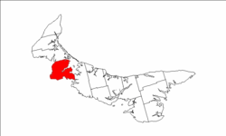
Richmond Parish, Prince Edward Island

Last updated
Map of Prince Edward Island highlighting Richmond Parish.png

Richmond Parish was created as a civil parish in Prince County, Prince Edward Island, Canada, during the 1764-1766 survey of Samuel Holland.

Civil parish territorial designation and lowest tier of local government in England, UK

In England, a civil parish is a type of administrative parish used for local government, they are a territorial designation which is the lowest tier of local government below districts and counties, or their combined form, the unitary authority. Civil parishes can trace their origin to the ancient system of ecclesiastical parishes which historically played a role in both civil and ecclesiastical administration; civil and religious parishes were formally split into two types in the 19th century and are now entirely separate. The unit was devised and rolled out across England in the 1860s.

Prince County, Prince Edward Island Place

Prince County is located in western Prince Edward Island, Canada. The county's defining geographic feature is Malpeque Bay, a sub-basin of the Gulf of St. Lawrence, which creates the narrowest portion of Prince Edward Island's landmass, an isthmus upon which the city of Summerside is located.

Prince Edward Island Province of Canada

Prince Edward Island is a province of Canada consisting of the Atlantic island of the same name along with several much smaller islands nearby. Prince Edward Island is one of the three Maritime Provinces and is the smallest province in both land area and population, but the most densely populated. It is part of the traditional lands of the Mi'kmaq, and became a British colony in the 1700s and was federated into Canada as a province in 1873. Its capital is Charlottetown. According to the 2016 census, the province of Prince Edward Island has 142,907 residents.

It contains the following townships:

Coordinates: 46°25′48.8″N64°2′50.5″W / 46.430222°N 64.047361°W / 46.430222; -64.047361

Geographic coordinate system Coordinate system

A geographic coordinate system is a coordinate system that enables every location on Earth to be specified by a set of numbers, letters or symbols. The coordinates are often chosen such that one of the numbers represents a vertical position and two or three of the numbers represent a horizontal position; alternatively, a geographic position may be expressed in a combined three-dimensional Cartesian vector. A common choice of coordinates is latitude, longitude and elevation. To specify a location on a plane requires a map projection.

Related Research Articles

Dundas Parish, New Brunswick Parish in New Brunswick, Canada

Dundas is a Canadian parish in Kent County, New Brunswick.

Lot 36, Prince Edward Island Township in Prince Edward Island, Canada

Lot 36 is a township in Queens County, Prince Edward Island, Canada. It is part of Bedford Parish. Lot 36 was awarded to merchants George Spence and John Mill in the 1767 land lottery. It was sold to Donald MacDonald in 1775.

North Parish, Prince Edward Island

North Parish was created as a civil parish in Prince County, Prince Edward Island, Canada, during the 1764-1766 survey of Samuel Holland.

Egmont Parish, Prince Edward Island

Egmont Parish was created as a civil parish in Prince County, Prince Edward Island, Canada, during the 1764-1766 survey of Samuel Holland.

Halifax Parish, Prince Edward Island

Halifax Parish was created as a civil parish in Prince County, Prince Edward Island, Canada, during the 1764-1766 survey of Samuel Holland.

St. Davids Parish, Prince Edward Island human settlement

St. David's Parish was created as a civil parish in Prince County, Prince Edward Island, Canada, during the 1764-1766 survey of Samuel Holland.

Hillsboro Parish, Prince Edward Island

Hillsboro Parish was created as a civil parish in Queens County, Prince Edward Island, Canada, during the 1764-1766 survey of Samuel Holland.

Charlotte Parish, Prince Edward Island

Charlotte Parish was created as a civil parish in Queens County, Prince Edward Island, Canada, during the 1764-1766 survey of Samuel Holland.

Bedford Parish, Prince Edward Island

Bedford Parish was created as a civil parish in Queens County, Prince Edward Island, Canada, during the 1764-1766 survey of Samuel Holland.

St. Johns Parish, Prince Edward Island

St. John's Parish was created as a civil parish in Queens County, Prince Edward Island, Canada, during the 1764-1766 survey of Samuel Holland.

St Patricks (civil parish, Prince Edward Island)

St. Patrick's Parish was created as a civil parish in Kings County, Prince Edward Island, Canada, during the 1764-1766 survey of Samuel Holland.

East Parish, Prince Edward Island

East Parish was created as a civil parish in Kings County, Prince Edward Island, Canada, during the 1764-1766 survey of Samuel Holland.

St. Georges Parish, Prince Edward Island

St. George's Parish was created as a civil parish in Kings County, Prince Edward Island, Canada, during the 1764-1766 survey of Samuel Holland.

St. Andrews Parish, Prince Edward Island

St. Andrew's Parish was created as a civil parish in Kings County, Prince Edward Island, Canada, during the 1764-1766 survey of Samuel Holland.

Wellington, Prince Edward Island rural municipality in Prince Edward Island

Wellington is a municipality that holds community status in Prince Edward Island, Canada. It is located in Prince County, and extends as Wellington Centre onto Route 2 from Richmond through to St. Nicholas.

Abram-Village is a Canadian rural municipality located in Prince County, Prince Edward Island.

Grenville Parish, Prince Edward Island

Grenville Parish was created as a civil parish in Queens County, Prince Edward Island, Canada, during the 1764-1766 survey of Samuel Holland.

Wakefield Parish, New Brunswick Parish in New Brunswick, Canada

Wakefield is a Canadian parish in Carleton County, New Brunswick.

Roxbury, Prince Edward Island human settlement in Canada

Roxbury, a community of Lot 6 is a settlement in Prince Edward Island.