This page is based on this
Wikipedia article Text is available under the
CC BY-SA 4.0 license; additional terms may apply.
Images, videos and audio are available under their respective licenses.

Dundas is a Canadian parish in Kent County, New Brunswick.

Tərtər is a city in and the capital of the Tartar Rayon of Azerbaijan.

Lot 36 is a township in Queens County, Prince Edward Island, Canada. It is part of Bedford Parish. Lot 36 was awarded to merchants George Spence and John Mill in the 1767 land lottery. It was sold to Donald MacDonald in 1775.

St. David's Parish was created as a civil parish in Prince County, Prince Edward Island, Canada, during the 1764-1766 survey of Samuel Holland.

Hillsboro Parish was created as a civil parish in Queens County, Prince Edward Island, Canada, during the 1764-1766 survey of Samuel Holland.

Charlotte Parish was created as a civil parish in Queens County, Prince Edward Island, Canada, during the 1764-1766 survey of Samuel Holland.

St. George's Parish was created as a civil parish in Kings County, Prince Edward Island, Canada, during the 1764-1766 survey of Samuel Holland.

St. Andrew's Parish was created as a civil parish in Kings County, Prince Edward Island, Canada, during the 1764-1766 survey of Samuel Holland.

Freeland is a Canadian rural community in Prince County, Prince Edward Island.

Grenville Parish was created as a civil parish in Queens County, Prince Edward Island, Canada, during the 1764-1766 survey of Samuel Holland.
West Chatfield Beach is a hamlet in the Canadian province of Saskatchewan. Listed as a designated place by Statistics Canada, the hamlet had a population of 25 in the Canada 2006 Census.

Woodstock is a Canadian parish in Carleton County, New Brunswick.
Rocky Point is a settlement in Prince Edward Island. It is part of Lot 65 in Hillsboro Parish. Rocky Point had been the location of an annual Mi'kmaq summer coastal community prior to European settlement.

Burgess is an unincorporated community in Northumberland County, in the U.S. state of Virginia.
Brokenhead Ojibway Nation is an Anishinaabe (Saulteaux/Ojibwa) First Nation located approximately 64 kilometres (40 mi) northeast of Winnipeg, Manitoba. As of May 2010, the First Nation had a registered population of 1,733 people, of which their own on-reserve population was 598. The main reserve of Brokenhead 4 is surrounded by the Rural Municipality of St. Clements, except for a small lakeshore on Lake Winnipeg.

Indian River is a 59.1-mile-long (95.1 km) tributary of the Manistique River on the Upper Peninsula of Michigan in the United States. It rises out of Hovey Lake at 46°17′36″N 86°42′20″W on Hiawatha National Forest land in Alger County and flows south and east through a lake district and on through Schoolcraft County. The river flows into the 8,659 acre (35 km²) Indian Lake at 46°17′36″N 86°42′20″W and flows out at 45°59′30″N 86°17′15″W. It then flows east and south about 2.5 miles where it merges with the Manistique River, which then flows through Manistique and into Lake Michigan at 45°56′56″N 86°14′45″W.
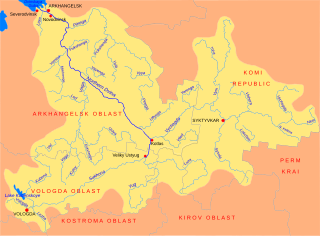
The Mekhrenga is a river in Plesetsky and Kholmogorsky Districts and in the town of Mirny of Arkhangelsk Oblast in Russia. It is a left tributary of the Yemtsa River. It is 231 kilometres (144 mi) long, and the area of its basin 5,080 square kilometres (1,960 sq mi). The principal tributaries of the Mekhrenga are the Shorda (left), the Myagdoma (right), and the Puksa (left).

Filchampstead is a hamlet within Cumnor Parish, Oxfordshire. Until the 1974 boundary changes it was in Berkshire. It lies on the Cumnor Road (B4017) between Farmoor and Cumnor village, at the foot of a hill known locally as 'Tumbledown Dick'.
