Prince Edward Island is an island province of Canada. While it is the smallest province in terms of land area and population, it is the most densely populated. The island has several nicknames: "Garden of the Gulf", "Birthplace of Confederation" and "Cradle of Confederation". Its capital and largest city is Charlottetown. It is one of the three Maritime provinces and one of the four Atlantic provinces.

The Prince Edward Island Railway (PEIR) was a historic Canadian railway in Prince Edward Island (PEI). The railway ran tip-to-tip on the island, from Tignish in the west to Elmira in the east, with major spurs serving Borden-Carleton's train ferry dock, the capital in Charlottetown, Montague and Georgetown and the original eastern terminus at Souris. A major spur from Charlottetown served Murray Harbour on the south coast.

Borden-Carleton is a town in Prince County in the Canadian province of Prince Edward Island. It is situated on the south shore fronting on the Northumberland Strait. The town was originally incorporated as a community on April 12, 1995, through the amalgamation of the town of Borden and the community of Carleton. The town of Borden opted to demote its status to a community in light of a declining tax base with the pending completion of the Confederation Bridge and the closure of the Marine Atlantic ferry service. Borden-Carleton became a town on July 31, 2012.

Lot 4 is a township in Prince County, Prince Edward Island, Canada created during the 1764–1766 survey of Samuel Holland. It is part of Egmont Parish.
Alberton is a Canadian town located in Prince County, Prince Edward Island. It is situated in the western part of the county in the township of Lot 5.

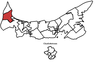
Prince County is located in western Prince Edward Island, Canada. The county's defining geographic feature is Malpeque Bay, a sub-basin of the Gulf of St. Lawrence, which creates the narrowest portion of Prince Edward Island's landmass, an isthmus upon which the city of Summerside is located.

Georgetown is a community located within the municipality of Three Rivers in Kings County, Prince Edward Island, Canada. It is the Capital of Kings County. Previously incorporated as a town, it amalgamated with the town of Montague, the rural municipalities of Brudenell, Cardigan, Lorne Valley, Lower Montague, and Valleyfield, and portions of three adjacent unincorporated areas in 2018.
Belmont is a Canadian rural farming community located in the larger community of Lot 16 in central Prince County, Prince Edward Island. Lot 16 is actually three communities: Belmont, Central, and Southwest Lot 16, and is one of the last communities on Prince Edward Island to continue using their lot designation from the original Island survey by Samuel Holland in the 18th century.
Belfast is a rural municipality in Prince Edward Island, Canada. It is located in southeastern Queens County in the townships of Lot 57 and Lot 58.

Wood Islands is a rural farming and fishing community located in southeastern Queens County, Prince Edward Island on the Northumberland Strait. It takes its name from several small forested islands, then located several hundred metres offshore in the Northumberland Strait. The community of Wood Islands falls within the larger PEI Township of Lot 62, which had a population in 2011 of 470 residents, a 13% decrease from the 2006 census count of 540. While the named islands are located on maps by Jacques-Nicolas Bellin: Karte Bellin, 1744: 'I a Bova' and Louis Franquet: Cartes Franquet, 1751: 'Isle a Bois', it was Samuel Johannes Holland who correctly surveyed and depicted the islands, about their basin. The 'European' settlement of Wood Islands began in 1803, but saw its most noted arrivals in 1807 with the arrival, after wintering in Pinette, of a large party of Scottish settlers from the Spencer.

Palmer Road, labelled Route 156, is a 2-lane collector highway in western Prince County, Prince Edward Island, Canada. It is between the communities of Tignish and Miminegash. Its maximum speed limit is 80 km/h (50 mph). The road is considered part of two larger communities, Tignish and Miminegash.
Greenmount Road, labelled Route 153, is a 2-lane collector highway in western Prince County, Prince Edward Island, Canada. It is between the communities of Tignish and Alberton. Its maximum speed limit is 90 km/h (56 mph). The road is considered part of two larger communities, Tignish and Alberton.
Alberton-Roseville was a provincial electoral district for the Legislative Assembly of Prince Edward Island, Canada. It was formerly known as Alberton-Miminegash from 1996 to 2007.
St. Louis is a municipality that holds community status in Prince Edward Island, Canada.
Holy Trinity Anglican Church is a large historic Carpenter Gothic style Anglican church building located at 40986 Western Road in the unincorporated village of Alma, 4 miles north of Alberton, Prince Edward Island Canada. It was built of wood between 1888 and 1890 by local craftsmen Its steep pitched roof, lancet windows and entrance tower are typical of Carpenter Gothic churches. Its rear chancel has a separate roof line and appears to be an add on. The adjacent cemetery predates the church by one year. Because of its "well preserved carpenter Gothic architecture", its "association with the history of the Anglican Church in western Prince Edward Island" and "its contribution" to the community of Alma", it was designated a provincial heritage site by the province of Prince Edward Island on December 21, 2007.
Health PEI is the single health authority for the Canadian province of Prince Edward Island. It delivers medical care on behalf of the Government of Prince Edward Island's Department of Health and Wellness and is governed by a board of directors appointed by the Minister of Health and Wellness.

Prince Edward Island Potatoes refers to the brand and geographic identifier for potatoes grown and packaged in Prince Edward Island, a Maritime Province on the Atlantic coast of Canada.
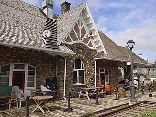
The Kensington Railway Station is a National Historic Site of Canada, located in the town of Kensington, Prince Edward Island. The train station was the third built at the site, and one of two "boulder stations" built by Charles Benjamin Chappell in 1904, so named for the fieldstone composing its exterior walls.
The COVID-19 pandemic in Prince Edward Island is part of an ongoing global pandemic of coronavirus disease 2019 (COVID-19), an infectious disease caused by severe acute respiratory syndrome coronavirus 2 (SARS-CoV-2). Up until January 14, 2022, Prince Edward Island was the only province/territory that did not have any deaths due to COVID-19.
Spring Bay is a rural community in Lot 18, Prince County, Prince Edward Island, Canada. Spring Bay is part of the incorporated municipality of Malpeque Bay.

