Victoria is the capital city of the Canadian province of British Columbia, on the southern tip of Vancouver Island off Canada's Pacific coast. The city has a population of 91,867, and the Greater Victoria area has a population of 397,237. The city of Victoria is the seventh most densely populated city in Canada with 4,406 inhabitants per square kilometre (11,410/sq mi).

Saanich is a district municipality on Vancouver Island in British Columbia, within the Greater Victoria area. The population was 117,735 at the 2021 census, making it the most populous municipality in the Capital Regional District and Vancouver Island, and the eighth-most populous in the province. The district adopted its name after the Saanich First Nation, meaning "emerging land" or "emerging people". The district acts as a bedroom community immediately to the north of Victoria, British Columbia.

Greater Victoria is located in British Columbia, Canada, on the southern tip of Vancouver Island. It is usually defined as the thirteen municipalities of the Capital Regional District (CRD) on Vancouver Island as well as some adjacent areas and nearby islands.

Fernwood is a neighbourhood near downtown Victoria, British Columbia, Canada, bounded by the neighbourhoods of North/South Jubilee, North Park, Fairfield, Rockland, Hillside-Quadra, Oaklands and Harris Green.

Oak Bay-Gordon Head is a provincial electoral district for the Legislative Assembly of British Columbia, Canada.

Uplands, Victoria is a 188.17-hectare (465.0-acre) neighbourhood located in the north east part of the District of Oak Bay, a suburb adjacent to Victoria, British Columbia, Canada, and situated between the neighbourhoods of Cadboro Bay and North Oak Bay. Uplands is a prominent example of a garden suburb designed in the early part of the 20th century.
The District of North Saanich is located on the Saanich Peninsula of British Columbia, approximately 25 km (16 mi) north of Victoria on southern Vancouver Island. It is one of the 13 Greater Victoria municipalities. The district is surrounded on three sides by 20 km (12 mi) of ocean shoreline, and consists of rural/residential areas and a large agricultural base. It is home to the Victoria International Airport and the Swartz Bay Ferry Terminal.

Mount Douglas, usually referred to as Mount Doug by locals, is a prominent, 225 m (738 ft) hill in Saanich, British Columbia. It is located in (PKOLS) Mount Douglas Park in the municipality of Saanich.
Saanich Peninsula is located north of Victoria, British Columbia, Canada. It is bounded by Saanich Inlet on the west, Satellite Channel on the north, the small Colburne Passage on the northeast, and Haro Strait on the east. The exact southern boundary of what is referred to as the "Saanich Peninsula" is somewhat fluid in local parlance.

Discovery Island is located off the eastern side of Vancouver Island and is viewable from Ten Mile Point, near Cadboro Bay, and Oak Bay. Discovery Island Marine Provincial Park occupies the southern portion of Discovery Island, 3 miles (4.8 km) east of Oak Bay. The northern portion of the island is part of Discovery Island Indian Reserve 3, under the control of the Songhees First Nation.
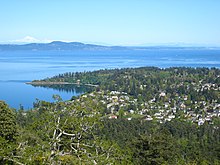
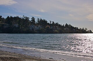
Cadboro Bay is a bay near the southern tip of Vancouver Island and its adjacent neighbourhood in the municipalities of Saanich and Oak Bay in Greater Victoria, British Columbia, Canada.

The Craigflower Manor and Craigflower Schoolhouse are National Historic Sites of Canada located in View Royal, British Columbia and Saanich near Victoria. The centerpiece of each historic site is a 19th-century building — a manor and schoolhouse commissioned by the Hudson's Bay Company to provide education and lodging for their employees. Built as part of the agricultural community Craigflower Farm, the buildings served as a focal point for the community into the modern era; they remain open to the public today as museums devoted to the colonial history of Victoria.

Victoria Harbour is a harbour, seaport, and seaplane airport in the Canadian city of Victoria, British Columbia. It serves as a cruise ship and ferry destination for tourists and visitors to the city and Vancouver Island. It is both a port of entry and an airport of entry for general aviation. Historically it was a shipbuilding and commercial fishing centre. While the Inner Harbour is fully within the City of Victoria, separating the city's downtown on its east side from the Victoria West neighbourhood, the Upper Harbour serves as the boundary between the City of Victoria and the district municipality of Esquimalt. The inner reaches are also bordered by the district of Saanich and the town of View Royal. Victoria is a federal "public harbour" as defined by Transport Canada. Several port facilities in the harbour are overseen and developed by the Greater Victoria Harbour Authority, however the harbour master's position is with Transport Canada.
Ten Mile Point is a neighbourhood in the District of Saanich in Victoria, British Columbia, and is the most easterly point on Vancouver Island. Ten Mile Point was so named because it was ten nautical miles from what was at the time the headquarters of the Pacific Station of the Royal Navy. Ten Mile Point is a wooded peninsula that forms one side of Cadboro Bay, the home of the Royal Victoria Yacht Club and the mythical Cadborosaurus sea monster. Cadboro Point is located on the east part of this peninsula. Prevost Hill was named after James Charles Prevost, British commissioner in the negotiations to settle the San Juan boundary dispute. Prevost Hill is the highest elevation on Ten Mile Point and is known informally in the neighbourhood as "Minnie Mountain". Prevost Hill is the location for a subdivision within Ten Mile Point called "Wedgewood Point" or "Wedgewood Estates". A small wooded island, "Flower Island", almost touches the southern shore of Ten Mile Point. Ten Mile Point has many secluded beaches and coves.
The Tseycum First Nation is a First Nations government located on Vancouver Island. In the 1850s they were signatories to the Douglas Treaties.
Haro Woods is one of the few urban forests remaining in the Municipality of Saanich, one of the 13 municipalities which make up the Capital Regional District (CRD) on the south portion of Vancouver Island. It is similar in beauty to Mystic Vale, the forested ravine located to the south east and outside of the University of Victoria (UVIC) campus. Mystic Vale is on the list of protected areas of British Columbia.

Victoria West, commonly called Vic West, is an historic neighbourhood of the city of Victoria, British Columbia, Canada, located just west of downtown across Victoria Harbour, bordering on the Township of Esquimalt.
Mount Tolmie, elevation 120 m (394 ft), is a hill and surrounding neighbourhood in Saanich, Greater Victoria, British Columbia. The majority of the mountain forms Mount Tolmie Park, a municipal park, while the south side has several private residences. The peak of the hill is known for its excellent views of Victoria, the Olympic Mountains, and the San Juan Islands.
The 1862 Pacific Northwest smallpox epidemic was a smallpox outbreak that started in Victoria on Vancouver Island and spread among the indigenous peoples of the Pacific Northwest Coast and into the indigenous peoples of the Northwest Plateau, killing a large portion of natives from the Puget Sound region to Southeast Alaska. Two-thirds of British Columbia natives died—around 20,000 people. The death rate was highest in southeast Alaska and Haida Gwaii—over 70% among the Haida and 60% among the Tlingit. Almost all native nations along the coast, and many in the interior, were devastated, with a death rate of over 50% for the entire coast from Puget Sound to Sitka, Alaska, part of Russian America at the time. In some areas the native population fell by as much as 90%. The disease was controlled among colonists in 1862 but it continued to spread among natives through 1863.
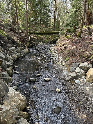
Douglas Creek is a small, 0.8 kilometres (0.50 mi) salmon-bearing urban stream that is located in the municipality of Saanich on Vancouver Island. It is located entirely within PKOLS and its mouth empties into Haro Strait.