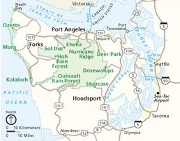
The Olympic Peninsula is the large arm of land in western Washington that lies across Puget Sound from Seattle, and contains Olympic National Park. It is bounded on the west by the Pacific Ocean, the north by the Strait of Juan de Fuca, and the east by Hood Canal. Cape Alava, the westernmost point in the contiguous United States, and Cape Flattery, the northwesternmost point, are on the peninsula. Comprising about 3600 square miles, the Olympic Peninsula contained many of the last unexplored places in the Contiguous United States. It remained largely unmapped until Arthur Dodwell and Theodore Rixon mapped most of its topography and timber resources between 1898 and 1900.

Sooke is a district municipality on the southern tip of Vancouver Island, Canada, 38 kilometres by road from Victoria, the capital of British Columbia. Sooke, the westernmost of Greater Victoria's Western Communities, is to the north and west of the Sooke Basin.

Spadina Avenue is one of the most prominent streets in Toronto, Ontario, Canada. Running through the western section of downtown, the road has a very different character in different neighbourhoods.

The Porcupine Mountains, or Porkies, are a group of small mountains spanning the northwestern Upper Peninsula of Michigan in Ontonagon and Gogebic counties, near the shore of Lake Superior. The Porcupine Mountains were named by the native Ojibwa people, supposedly because their silhouette had the shape of a crouching porcupine. They are home to the most extensive stand of old growth northern hardwood forest in North America west of the Adirondack Mountains, spanning at least 31,000 acres (13,000 ha). In these virgin forests, sugar maple, American basswood, eastern hemlock, and yellow birch are the most abundant tree species. The area is part of the Porcupine Mountains Wilderness State Park.
The Chugach National Forest is a 6,908,540-acre (27,958 km2) United States National Forest in south central Alaska. Covering portions of Prince William Sound, the Kenai Peninsula and the Copper River Delta, it was formed in 1907 from part of a larger forest reserve. The Chugach includes extensive shorelines, glaciers, forests and rivers, much of which is untouched by roads or trails. It hosts numerous bird, mammal and marine species, including extensive shorebird habitat and a bald eagle population larger than the contiguous 48 states combined. Human industry in the forest includes extensive tourism and some mining and oil and gas operations.

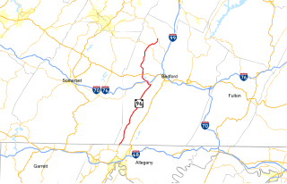
M-123 is a state trunkline highway in the eastern Upper Peninsula of the U.S. state of Michigan. It is one of only a few highways in Michigan that curve around and form a U-shape. In fact, M-123 has three intersections with only two state trunklines; it meets M-28 twice as a result of its U-shaped routing. M-123 also has a rare signed concurrency with a County-Designated Highway in Michigan; in Trout Lake, there is a concurrency with H-40. All of M-123 north of M-28 is a Scenic Heritage Route within the Michigan Heritage Route system.

Arnos Grove is an area of North London, England, within the London Borough of Enfield. It is centred 7.5 miles (12 km) north of Charing Cross and was a medieval demesne and estate of the Arnolds, a Norman-heritage family, in Middlesex. It is within New Southgate. The natural grove, larger than today, was for many centuries the largest woodland in the chapelry of Southgate in the parish of Edmonton. It became inter-related with Arnos Park when its owner was permitted to enclose much of its area through the widespread legal practice of inclosure of the common land to create the former park, the heart of which is now public parkland.

The North Coast of California is the region in Northern California that lies on the Pacific coast between San Francisco Bay and the Oregon border. It commonly includes Mendocino, Humboldt, and Del Norte counties and sometimes includes two counties from the San Francisco Bay area, Marin and Sonoma.
Pennsylvania Route 96 is a 41 2⁄3-mile-long (67.1 km) state highway located in southwestern Pennsylvania. The southern terminus of the route is at the Mason–Dixon line in Londonderry Township, where PA 96 continues to the south as Maryland Route 35. The northern terminus is at Pennsylvania Route 869 in Lincoln Township.

The Ha-De-Ron-Dah Wilderness Area, an Adirondack Park unit of New York's Forest Preserve, is located in the town of Webb, Herkimer County, and the Town of Greig, Lewis County. It is bounded on the north by private lands in the vicinity of North Pond, Hitchcock Pond, Moose Pond and the headwaters of the Independence River; on the east by private lands along the Remsen to Lake Placid railroad right-of-way; on the south by private lands along NY 28 and by the wood road leading to the Copper Lake property; and on the west by Pine Creek and a DEC maintained foot trail from Pine Creek to Pine Lake, East Pine Pond, and Big Otter Lake.

Highland Creek is a river in the Scarborough district of Toronto, Ontario, emptying into Lake Ontario at the eastern end of the Scarborough Bluffs. It is home to several species of fish including trout, carp, bass and salmon. It is a meandering river which, like most rivers in Toronto, travels through a glacial ravine formed after the last Ice Age. The Highland Creek watershed, including tributaries, is almost entirely contained within Scarborough.

{{}}
The Sharon Valley Historic District is located around the junction of Kings Hill, Sharon Valley and Sharon Station roads in Sharon, Connecticut, United States. It is a small community that grew up around an iron mining and refining operation during the late 19th century, the first industry in Sharon.
Barnes Point is an ancient landslide delta that juts out into Lake Crescent in Clallam County, Washington. As one of the few areas of relatively flat ground near Lake Crescent, it hosts Lake Crescent Lodge, the Storm King Ranger Station of Olympic National Park, as well as several private homes. It also contains the trails which access Mount Storm King, Marymere Falls, and Barnes Creek. Barnes Creek flows through an old-growth forest, providing spawning habitat for the endemic Crescenti cutthroat trout.

The Sooke Flowline is an abandoned 44-kilometre (27 mi) concrete aqueduct that snakes through the Sooke Hills from Sooke Lake to the Humpback Reservoir near Mt. Wells Regional Park. From this reservoir, a buried, riveted steel pressure main transported water to Victoria. In between 1994 and 2007, this main was replaced since it was long past its useful life. The flowline was vital to the continued growth of the City of Victoria as it provided a reliable water supply.

Park Crescent is a mid-19th-century residential development in the Round Hill area of Brighton, part of the English city of Brighton and Hove. The horseshoe-shaped, three-part terrace of 48 houses was designed and built by one of Brighton's most important architects, Amon Henry Wilds; by the time work started in 1849 he had 35 years' experience in the town. Wilds used the Italianate style rather than his more common Regency motifs. Three houses were replaced after the Second World War because of bomb damage, and another was the scene of one of Brighton's notorious "trunk murders" of the 1930s. The three parts of the terrace, which encircle a private garden formerly a pleasure ground and cricket pitch, have been listed at Grade II* by English Heritage for their architectural and historical importance.

Monken Hadley Common lies within the Monken Hadley Conservation Area, and is listed as a “Site of Borough Importance for Nature Conservation, Grade I,” by the London Borough of Barnet. It is registered common land, and it is owned by the Trustees of Monken Hadley Common.

Gull Point State Park is a state park of Iowa, United States, located on West Okoboji Lake in the city of Wahpeton. It is the primary state park unit in the Iowa Great Lakes region. Two areas of the park were listed as nationally recognized historic districts on the National Register of Historic Places in 1990.

Shady Lake Recreation Area is a campground and public recreation area in southwestern Ouachita National Forest, southwest of Mena, Arkansas and west of Glenwood, Arkansas. The area is oriented around Shady Lake, a body of water on the South Fork Saline River impounded by a dam built c. 1940 by the Civilian Conservation Corps (CCC). The area is administered by the United States Forest Service (USFS).

New Discovery State Park is a state park near Marshfield, Vermont in the United States. It is one of seven state parks located in Groton State Forest. The park is on Vermont Route 232, offering camping, picnicking, and access to forest trails. The park was developed in the 1930s by the Civilian Conservation Corps; its major CCC-built facilities, located mainly in western Peacham, were listed on the National Register of Historic Places in 2002.