
Victoria is the capital city of the Canadian province of British Columbia, on the southern tip of Vancouver Island off Canada's Pacific coast. The city has a population of 91,867, and the Greater Victoria area has a population of 397,237. The city of Victoria is the seventh most densely populated city in Canada with 4,406 inhabitants per square kilometre (11,410/sq mi).
Upland or Uplands may refer to:

Saanich is a district municipality on Vancouver Island in British Columbia, within the Greater Victoria area. The population was 117,735 at the 2021 census, making it the most populous municipality in the Capital Regional District and Vancouver Island, and the eighth-most populous in the province. The district adopted its name after the Saanich First Nation, meaning "emerging land" or "emerging people". The District acts as a bedroom community immediately to the north of Victoria, British Columbia.

Greater Victoria is located in British Columbia, Canada, on the southern tip of Vancouver Island. It is usually defined as the thirteen municipalities of the Capital Regional District (CRD) on Vancouver Island as well as some adjacent areas and nearby islands.

Fernwood is a neighbourhood near downtown Victoria, British Columbia, Canada, bounded by the neighbourhoods of North/South Jubilee, North Park, Fairfield, Rockland, Hillside-Quadra, Oaklands and Harris Green.

Oak Bay is a municipality incorporated in 1906 that is located on the southern tip of Vancouver Island, in the Canadian province of British Columbia. It is one of thirteen member municipalities of the Capital Regional District, and is bordered to the west by the city of Victoria and to the north by the district of Saanich. It is an eastern residential suburb of Victoria

Oak Bay-Gordon Head is a provincial electoral district for the Legislative Assembly of British Columbia, Canada.

Mount Burke, 1,270 m (4,167 ft), is a mountain located in northeast Coquitlam, British Columbia, north of Port Coquitlam on the ridge system leading to Coquitlam Mountain. Most of the mountain is part of Pinecone Burke Provincial Park. Mount Burke is found in Coquitlam near Minnekhada Regional Park.
The District of North Saanich is located on the Saanich Peninsula of British Columbia, approximately 25 km (16 mi) north of Victoria on southern Vancouver Island. It is one of the 13 Greater Victoria municipalities. The district is surrounded on three sides by 20 km (12 mi) of ocean shoreline, and consists of rural/residential areas and a large agricultural base. It is home to the Victoria International Airport and the Swartz Bay Ferry Terminal.

Nopiming Provincial Park is a natural provincial park in Manitoba, Canada, located on the southeast side of the province, along the boundary with Ontario.

Patrick Arena (1911–1929) was the main sports arena located in the Greater Victoria, British Columbia area. The wood construction, brick-faced arena was located in the suburb municipality of Oak Bay, on the northeast corner of Cadboro Bay Road and Epworth Street. Built in 1911 at a cost of $110,000 with a capacity for 4,000 spectators, it officially opened with public skating on December 25, 1911. More than 600 skaters enjoyed the thrill of opening day. The owners, Frank and Lester Patrick, built the arena primarily to accommodate their hockey team in the newly formed Pacific Coast Hockey Association (PCHA). The Patrick Arena was destroyed by fire in 1929.

Discovery Island is located off the eastern side of Vancouver Island and is viewable from Ten Mile Point, near Cadboro Bay, and Oak Bay. Discovery Island Marine Provincial Park occupies the southern portion of Discovery Island, 3 miles (4.8 km) east of Oak Bay. The northern portion of the island is part of Discovery Island Indian Reserve 3, under the control of the Songhees First Nation.
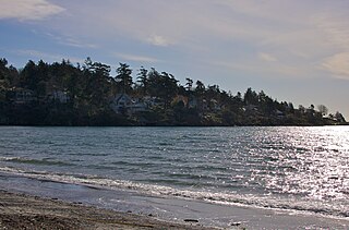
Cadboro Bay is a bay near the southern tip of Vancouver Island and its adjacent neighbourhood in the municipalities of Saanich and Oak Bay in Greater Victoria, British Columbia, Canada.

Gordon Head is a seaside neighbourhood in the municipality of Saanich in Greater Victoria, British Columbia, Canada. Gordon Head lies north of McKenzie Avenue and east of the Blenkinsop Valley. The University of Victoria is located partly within Gordon Head along the southeast boundary. Finnerty Road separates Gordon Head from the adjacent neighbourhood of Cadboro Bay. The local area is dominated physically by Mount Douglas, a coastline along Haro Strait, and the central plateau.


Victoria Harbour is a harbour, seaport, and seaplane airport in the Canadian city of Victoria, British Columbia. It serves as a cruise ship and ferry destination for tourists and visitors to the city and Vancouver Island. It is both a port of entry and an airport of entry for general aviation. Historically it was a shipbuilding and commercial fishing centre. While the Inner Harbour is fully within the City of Victoria, separating the city's downtown on its east side from the Victoria West neighbourhood, the Upper Harbour serves as the boundary between the City of Victoria and the district municipality of Esquimalt. The inner reaches are also bordered by the district of Saanich and the town of View Royal. Victoria is a federal "public harbour" as defined by Transport Canada. Several port facilities in the harbour are overseen and developed by the Greater Victoria Harbour Authority, however the harbour master's position is with Transport Canada.
Ten Mile Point is a neighbourhood in the District of Saanich in Victoria, British Columbia, and is the most easterly point on Vancouver Island. Ten Mile Point was so named because it was ten nautical miles from what was at the time the headquarters of the Pacific Station of the Royal Navy. Ten Mile Point is a wooded peninsula that forms one side of Cadboro Bay, the home of the Royal Victoria Yacht Club and the mythical Cadborosaurus sea monster. Cadboro Point is located on the east part of this peninsula. Prevost Hill was named after James Charles Prevost, British commissioner in the negotiations to settle the San Juan boundary dispute. Prevost Hill is the highest elevation on Ten Mile Point and is known informally in the neighbourhood as "Minnie Mountain". Prevost Hill is the location for a subdivision within Ten Mile Point called "Wedgewood Point" or "Wedgewood Estates". A small wooded island, "Flower Island", almost touches the southern shore of Ten Mile Point. Ten Mile Point has many secluded beaches and coves.

Tasiujaq is a northern village in Nunavik, in northern Quebec, Canada. Its population in the Canada 2021 Census was 420.
South Oak Bay is a neighbourhood located in the Municipality of Oak Bay, British Columbia, to the south of Oak Bay Avenue and lying east of the boundary between Oak Bay and Victoria, British Columbia.

The Royal Victoria Yacht Club is located along the shores of Cadboro Bay in The Uplands a neighborhood of Oak Bay, adjacent to the city of Victoria, British Columbia, Canada, and has facilities at Tseheum Harbour in Sidney.
