
Shaniko is a city located in Wasco County, Oregon, United States, on U.S. Route 97 and about 8 miles (13 km) north of Antelope. The population was 30 at the 2020 census.

Ordnance is a ghost town in Umatilla County, Oregon, United States, southwest of Hermiston on Interstate 84/U.S. Route 30, near the intersection with Interstate 82. In 1941, the United States Department of War commissioned the establishment of Umatilla Ordnance Depot in northern Umatilla County; it was later renamed Umatilla Army Depot and then Umatilla Chemical Depot. The town was named after the depot, and Ordnance post office was established in 1943. Due to gradual reductions in military funding for the area after World War II, by the 1960s, Ordnance was no longer a community.

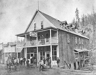
Whitney is an unincorporated community, also considered a ghost town, in Baker County, Oregon, United States, on Oregon Route 7 southwest of Sumpter. It is on the North Fork Burnt River, near the Blue Mountains and Wallowa-Whitman National Forest.
Friend is an unincorporated community in Wasco County in the U.S. state of Oregon. Considered a ghost town, little remains of the community except the Friend Store, a one-room schoolhouse, and a cemetery.
Auburn was an unincorporated community in rural Baker County, Oregon, United States, now considered a ghost town. Auburn lies off Oregon Route 7 southwest of Baker City and east of McEwen on the edge of the Blue Mountains.

Hardman is a historic community located in southern Morrow County, in the U.S. state of Oregon. It is on Oregon Route 207 about 20 miles (32 km) southwest of Heppner and 32 miles (51 km) north of Spray. Hardman is at an elevation of about 3,600 feet (1,100 m) in an agricultural area slightly west of the Blue Mountains of northeastern Oregon. Rock Creek, a tributary of the Columbia River, flows northwest by Hardman and to its south to meet the river at Lake Umatilla. A former social and commercial center for surrounding farm communities, Hardman became a ghost town following the completion of a railroad to Heppner in the 1920s. The main surviving commercial building, the Hardman IOOF Lodge Hall, was added to the National Register of Historic Places (NRHP) in 2012.
Bourne is a ghost town in Baker County, Oregon, United States about 7 miles (11 km) north of Sumpter in the Blue Mountains. It lies on Cracker Creek and is within the Wallowa–Whitman National Forest. Platted in 1902, the former gold mining boomtown is considered a ghost town today.
Eureka is a ghost town in Baker County, Oregon, United States, located along Cracker Creek, approximately 5 miles (8.0 km) north of Sumpter, and .6 miles (0.97 km) from Bourne. It was originally founded as a mining camp c. 1892, though by 1945 operations had ceased.
Monkland is an unincorporated community in Sherman County, Oregon, United States, on Monkland Lane between Sherman Highway 97 and Wasco-Heppner Highway 206. There are only two farms and farm homes located at Monkland.

Divide is a ghost town in Lane County, Oregon, United States, located southwest of Cottage Grove, near Interstate 5. A post office in Douglas County near a train station on the Southern Pacific Railroad was established on May 31, 1900, and it was closed on January 15, 1921. In 1909, the post office was relisted as a Lane County post office. It may have been moved across county borders, or its county may have changed during a shift in the border between Lane and Douglas counties.
Dryden is an unincorporated community in Josephine County, Oregon, United States. It is located in the Deer Creek Valley about five miles east of Selma. As of 1990 only one house remained; the 1920 structure formerly served as the Dryden Store and post office.
Blalock was an unincorporated community located in the Columbia River Gorge in Gilliam County, Oregon, United States. The town displaced a Native American settlement originally named Táwash. Blalock was located about 7 miles (11 km) west of Arlington on Interstate 84/U.S. Route 30 at the mouth of Blalock Canyon. Blalock is still the name of a station on the Union Pacific Railroad.

Blitzen is a ghost town in the Catlow Valley of southern Harney County, Oregon.
Early is a former community in Sherman County, Oregon, United States. It was located on the western bank of the John Day River about 5 miles up river to what is now La Page Park along Interstate 84. It was founded in 1902, with a post office established at this time. The post office was discontinued in 1919. In the 20th century, a flour mill operated in the town. It is contemporarily considered a ghost town.
Fargher is a former community in Sherman County, Oregon, United States. It was founded by Arthur W. Fargher, a native of the Isle of Man, who arrived in Oregon in 1878. The community's rail station was located near the Sherars Bridge. It is contemporarily considered a ghost town.
Gordon is a former community in Sherman County, Oregon, United States. It was first settled in 1875 by Tom Gordon, an Irish immigrant, and formally established with a post office in 1896, which only operated from July to December that year before closing. Gordon is contemporarily considered a ghost town.
Miller is a former community in Sherman County, Oregon, United States, established circa 1860. It was named for Thomas Jefferson Miller, a settler of the area, also for which Miller Island on the Columbia River takes its name. Miller is contemporarily considered a ghost town.
Thornberry is a former community in Sherman County, Oregon, United States, founded in 1916. Formerly known as Grebe, Thornberry was named for Harvey B. Thornberry, who became the second postmaster in January 1919. The town post office was officially closed in November 1923. Thornberry is contemporarily considered a ghost town.


