
The Neretva, also known as Narenta, is one of the largest rivers of the eastern part of the Adriatic basin. Four hydroelectric power plants with large dams provide flood protection, electicity and water storage. The Neretva is recognized for its natural environment and diverse landscapes.

Živinice is a city located in Tuzla Canton in the Federation of Bosnia and Herzegovina, an entity of Bosnia and Herzegovina. It is located in northeastern Bosnia and Herzegovina, south of Tuzla. As of 2013, it has a population of 57,765 inhabitants.

Žepče is a town and municipality located in Zenica-Doboj Canton of the Federation of Bosnia and Herzegovina, an entity of Bosnia and Herzegovina. It is situated in central Bosnia and Herzegovina, between Doboj and Zenica. As of 2013, it has a population of 30,219 inhabitants.

Čvrsnica is a mountain in the Dinarides of Bosnia and Herzegovina, located in northern Herzegovina. Most of the mountain is located in the Herzegovina-Neretva Canton municipalities of Mostar and Jablanica, while a small part of it, around 10%, is located in the municipality of Posušje. Pločno is the highest peak at 2,228 metres above sea level.
Nevesinje is a town and municipality in Republika Srpska, Bosnia and Herzegovina. As of 2013, the town has a population of 5,162 inhabitants, while the municipality has 12,961 inhabitants.

Olovo is a town and municipality located in the Zenica-Doboj Canton of the Federation of Bosnia and Herzegovina, an entity of Bosnia and Herzegovina. It is situated about 50 kilometers northeast of the capital city of Sarajevo and is located on the road between Sarajevo and Tuzla.

Trnovo is a town and municipality located in Sarajevo Canton of the Federation of Bosnia and Herzegovina, an entity of Bosnia and Herzegovina. As of 2013, the municipality had a population of 1,502 inhabitants. The town itself had a total population of 1,023, with 956 of them living in the Republika Srpska part and 67 in the Federation part.
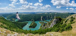
The Uvac is an international trans-boundary river, rising under Golija mountain and Pešter plateau, then flowing through southwestern Serbia and cross into eastern Bosnia and Herzegovina where, after 115 km, it finally meets the Lim river from the right, however, before it empties into the Lim, for a 10 kilometers Uvac forms the border between two countries. Also, while meandering through Serbia, Uvac loosely makes the northern border of the Raška region, too.

Blidinje plateau is a karst plateau in Bosnia and Herzegovina, situated at the heart of Dinaric Alps, between major mountains of the range, Čvrsnica, Čabulja and Vran, with characteristic karstic features such as Dugo Polje field, Blidinje Lake, Grabovica and Drežanka valleys, and others. It represents important natural, hydrogeological reservation in karst of Bosnia and Herzegovina, with significant cultural and historical heritage, and Dinarides in general.

Rakitnica is the main tributary of the first section of the Neretva river, also called Upper Neretva (Bosnian: Gornja Neretva). It meets Neretva from the right, flowing from north to south, between Bjelašnica and Visočica mountains.
The Grabovica massacre refers to the murders of at least 13 ethnic Croat inhabitants of the village of Grabovica near Jablanica by members of the Army of the Republic of Bosnia and Herzegovina (ARBiH) 9th Brigade and other unidentified members of ARBiH on 8 or 9 September 1993. The International Court Tribunal for former Yugoslavia concluded that the number of victims totaled to be 13, lower than the alleged amount of 33.

Upper Neretva, is the upper course of the Neretva river, including vast mountainous area surrounding the Neretva, with numerous human settlements, peaks and forests, numerous streams and well-springs, three major glacial lakes near the river and even more scattered across the mountains of Treskavica and Zelengora, in a wider area of the Upper Neretva with its flora and fauna.

The Rama is a river in Bosnia and Herzegovina, and a major tributary of the Neretva. It joins it from the right by discharging into Neretva's artificial reservoir, Jablaničko lake, at place called Marina Pećina, near village of Gračac, between location of underground powerhouse of Rama Hydroelectric Power Station and Jablanica Dam, depending on water level in Jablaničko lake, some 15 kilometers upstream from Jablanica.
The Grabovička River is one of the left tributaries of the Vrbanja River. It rises near Miljevići village, below the road to Golo Brdo, on the south slopes of Ježica and Zastijenje.

Doljani is populated place in Jablanica Municipality, Bosnia and Hercegovina, between Jablanica and Mostar. This village lies along the Doljanka river Doljani are located in the northern Herzegovina, in the northeastern part of the Nature Park "Blidinje". Elevation ranges from 600 to 750 meters in the place. The highest peaks that surround the village are Baćin, Borovinka, and Vitlenica Throughout the Doljani valley flowing the river Doljanka.
Gornja Jošanica massacre was the mass murder in the village of Gornja Jošanica, near Foča in eastern Bosnia, where 56 Bosnian Serb civilians were killed during an attack by the Army of the Republic of Bosnia and Herzegovina (ARBiH) from 19 December 1992, on St. Nicolas Day.
Grabovica Gornja is a village in the municipality of Tuzla, Tuzla Canton, Bosnia and Herzegovina.
Gornja Grabovica is a village in Valjevo, Serbia.
