Doljani, Jablanica

Last updated
Doljani
Дољани
Village
Doljani.jpg
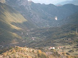
The view from the Obruč (Rim)
Bosnia and Herzegovina location map.svg
Red pog.svg
Doljani
Coordinates: 43°41′N17°40′E / 43.69°N 17.66°E / 43.69; 17.66
Country Flag of Bosnia and Herzegovina.svg  Bosnia and Herzegovina
Entity Federation of Bosnia and Herzegovina
Canton Flag of Herzegovina-Neretva.svg Herzegovina-Neretva
Municipality JablanicaGrb.gif Jablanica
Area
  Total18.56 sq mi (48.07 km2)
Population
 (2013)
  Total483
  Density26/sq mi (10/km2)
Time zone UTC+1 (CET)
  Summer (DST) UTC+2 (CEST)

Doljani is populated place in Jablanica Municipality, Bosnia and Hercegovina, between Jablanica and Mostar. This village lies along the Doljanka river (which was named after it) Doljani are located in the northern Herzegovina, in the northeastern part of the Nature Park "Blidinje". Elevation ranges from 600 to 750 meters in the place. The highest peaks that surround the village are Baćin (1,282 m), Borovinka (1430 m), and Vitlenica (1655 m) Throughout the Doljani valley flowing the river Doljanka. [1] [2]

Contents

History

Demography

Doljani
Total population in 2013: 568 [3]
Census Year1991.1981.1971.
Croats 708 (67,49%)731 (69,68%)754 (71,80%)
Bosniaks 326 (31,07%)316 (30,12%)294 (28,00%)
Serbs 01 (0,09%)1 (0,09%)
Yugoslavians 10 (0,95%)00
Others and unknown5 (0,47%)1 (0,09%)1 (0,09%)
Total1,0491,0491.050

According to the 2013 census, its population was 483. [4]

Ethnicity in 2013
EthnicityNumberPercentage
Croats 29360.7%
Bosniaks 18638.5%
other/undeclared40.8%
Total483100%

See also

Related Research Articles

Doljani is a village in Bosnia and Herzegovina. According to the 1991 census, the village is located in the municipality of Čapljina.

Herzegovina Historical region in the Balkans

Herzegovina is the southern and smaller of two main geographical regions of Bosnia and Herzegovina, the other being Bosnia. It has never had strictly defined geographical or cultural-historical borders, nor has it ever been defined as an administrative whole in the geopolitical and economic subdivision of Bosnia and Herzegovina.

Doljani is a village in the municipality of Hadžići, Bosnia and Herzegovina.

Doljani is a village in the municipality of Bihać, Bosnia and Herzegovina.

Doljani is a village in the municipality of Konjic, Bosnia and Herzegovina.

The Ćorkovac is an eastern confluent of the Vrbanja river in Bosnia. It begins on the north-eastern slopes of the Vlašić mountain's plateau, and the mouth opens at Šiprage, where the town's sawmill was. The spring of Ćorkovac is 1,150 metres above sea level, and its length is around 6 kilometres. It flows between the Jasen and Stražbenica mountains to its estuary. The watermills were in operation until the 1960s.

Vitovlje is a village in central Bosnia, in the Travnik Municipality, Federation of Bosnia and Herzegovina. It is located on the slopes of Vlašić Mountain, under Gavrića Brdo, at an altitude of about 900 m. In medieval Bosnia, Vitovlje was in the Parish of Mel.

Maslovare is a village in the central Bosnia, Bosnia and Herzegovina, Republika Srpska, Kotor Varoš Municipality.

Doljanka

Doljanka is a right tributary of Neretva river in North Herzegovina, Bosnia and Herzegovina.

Orahova is populated place in Bosnia and Herzegovina, Republika Srpska, Kotor-Varoš Municipality. Orahova includes two hamlets: Gornja and Lower (350 m) Orahova.

Turbe, Travnik Village in Federation of Bosnia and Herzegovina, Bosnia and Herzegovina

Turbe is a settlement in the Travnik municipality, Federation of Bosnia and Herzegovina, Bosnia and Herzegovina. The name is derived from Turkish türbe.

Ćorkovići (Ћорковићи) is populated place in Bosnia and Herzegovina, Kotor Varoš Municipality in Republika Srpska. In 1991, in this village lived 175 inhabitants, and 2013. : 101.

Donja Jablanica is a village in the municipality of Jablanica, Bosnia and Herzegovina.

Dragan Selo is a village in the municipality of Jablanica, Bosnia and Herzegovina.

Glodnica is a village in the municipality of Jablanica, Bosnia and Herzegovina.

Glogošnica is a village in the municipality of Jablanica, Bosnia and Herzegovina.

Gornje Paprasko is a village in the municipality of Jablanica, Bosnia and Herzegovina.

Krstac is a village in the municipality of Jablanica, Bosnia and Herzegovina.

Lug, Jablanica Village in Federation of Bosnia and Herzegovina, Bosnia and Herzegovina

Lug is a village in the municipality of Jablanica, Bosnia and Herzegovina. It is located along the Neretva river.

Mrakovo is a village in the municipality of Jablanica, Bosnia and Herzegovina.

References

  1. Spahić M. et al. (2000): Bosna i Hercegovina (1:250.000). Izdavačko preduzeće "Sejtarija", Sarajevo.
  2. Mučibabić B., ed. (1998). Geografski atlas Bosne i Hercegovine. Geodetski zavod BiH. Sarajevo. ISBN   9958-766-00-0.
  3. "Nezavisna Agencija za Statistiku Bosne i Hercegovine, naselje Doljani". nasbih.com. Retrieved 11 January 2017.
  4. "Naseljena Mjesta 1991/2013" (in Bosnian). Statistical Office of Bosnia and Herzegovina . Retrieved September 28, 2021.