Upper Bavaria is one of the seven administrative regions of Bavaria, Germany.
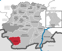
Garmisch-Partenkirchen is a Landkreis (district) in Bavaria, Germany. It is bounded by the districts of Ostallgäu, Weilheim-Schongau and Bad Tölz-Wolfratshausen, and by the Austrian state of Tyrol.

The Zugspitze, at 2,962 m (9,718 ft) above sea level, is the highest peak of the Wetterstein Mountains and the highest mountain in Germany. It lies south of the town of Garmisch-Partenkirchen in Bavaria, and the Austria–Germany border is on its western summit. South of the mountain is the Zugspitzplatt, a high karst plateau with numerous caves. On the flanks of the Zugspitze are two glaciers, the largest in Germany: the Northern Schneeferner with an area of 30.7 hectares and Höllentalferner with an area of 24.7 hectares. Shrinking of the Southern Schneeferner led to the loss of glacier status in 2022.

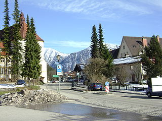
Garmisch-Partenkirchen is an Alpine ski town in Bavaria, southern Germany. It is the seat of government of the district of Garmisch-Partenkirchen, in the Oberbayern region, which borders Austria. Nearby is Germany's highest mountain, Zugspitze, at 2,962 metres (9,718 ft) above sea level.

Benediktbeuern is a municipality in the district of Bad Tölz-Wolfratshausen in Bavaria, Germany, 2 kilometers, or 1.25 miles from Bichl. The village has 3,602 residents as of 31 December 2019.

The Seilbahn Zugspitze is an aerial tramway running from the Eibsee Lake to the top of Zugspitze in Bavaria, Germany. It currently holds the world record for the longest freespan in a cable car at 3,213 metres (10,541 ft) as well as the tallest lattice steel aerial tramway support tower in the world at 127 metres (417 ft). Construction of the system began in 2015 and it opened on 22 December 2017.
Ettal is a German municipality and a village in the district of Garmisch-Partenkirchen in Bavaria.

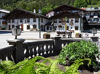
Mittenwald is a German municipality in the district of Garmisch-Partenkirchen, in Bavaria.

Eschenlohe is a German municipality in the district of Garmisch-Partenkirchen, in Bavaria, on the Loisach River.
Farchant is a municipality in the district of Garmisch-Partenkirchen, in Bavaria, Germany.
Krün is a municipality in the Upper Bavarian district of Garmisch-Partenkirchen. It belongs with Garmisch-Partenkirchen as district capital and cultural center as well as other municipalities to the region Werdenfelser Land. A few kilometers south runs the German-Austrian border.

Oberau is a municipality in the district of Garmisch-Partenkirchen, in Bavaria, Germany.

Ohlstadt is a municipality in the district of Garmisch-Partenkirchen, in Bavaria, Germany.
Wallgau is a municipality in the district of Garmisch-Partenkirchen, in Bavaria, Germany.

Maitenbeth is a municipality in the district of Mühldorf in Bavaria in Germany.

Vachendorf is a municipality in the district of Traunstein in Bavaria, Germany.

The Wetterstein mountains, colloquially called Wetterstein, is a mountain group in the Northern Limestone Alps within the Eastern Alps, crossing the Austria–Germany border. It is a comparatively compact range located between Garmisch-Partenkirchen, Mittenwald, Seefeld in Tirol and Ehrwald along the border between Germany (Bavaria) and Austria (Tyrol). Zugspitze, the highest peak is at the same time the highest mountain in Germany.
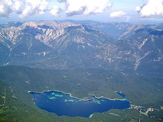
Eibsee is a lake in Bavaria, Germany, 9 km southwest of Garmisch-Partenkirchen and roughly 100 km southwest of Munich. It is 973.28 metres (3,193.2 ft) above sea-level and its surface area is 177.4 hectares. It is at the northerly base of the Zugspitze, Germany's highest mountain. The lake lies within the municipality of Grainau and is privately owned.

The Bavarian Zugspitze Railway is one of four rack railways still working in Germany, along with the Wendelstein Railway, the Drachenfels Railway and the Stuttgart Rack Railway. The metre gauge line runs from Garmisch in the centre of Garmisch-Partenkirchen to the Zugspitzplatt, approximately 300 metres below Zugspitze, the highest mountain in Germany. The line culminates at 2,650 metres above sea level, which makes it the highest railway in Germany and the third highest in Europe. It is also the railway in Europe with the biggest height difference: 1,945 metres, the lower half being open-air and the upper half being underground.

The Werdenfelser Land is a region of Upper Bavaria that extends from Mittenwald in the south to Farchant. It includes parts of the Bavarian Alps. From the Middle Ages until the Thirty Years' War, the Werdenfelser Land was subject to the Prince-Bishop of Freising, not the Duke of Bavaria.