Grant, Idaho

Last updated

Grant, Idaho
Grant, Idaho.jpg
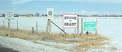
E 100 N or "Farm to Market Road" in Grant, Idaho
USA Idaho location map.svg
Red pog.svg
Grant
Usa edcp location map.svg
Red pog.svg
Grant
Coordinates: 43°38′28″N112°0′47″W / 43.64111°N 112.01306°W / 43.64111; -112.01306
Country United States
State Idaho
County Jefferson
Elevation
4,790 ft (1,460 m)
Time zone UTC-7 (Mountain (MST))
  Summer (DST) UTC-6 (MDT)
ZIP code
83442
Area code(s) 208, 986
GNIS feature ID372901 [1]
Entering Grant, Idaho on Lewisville Highway, northbound Entering Grant, Idaho.jpg
Entering Grant, Idaho on Lewisville Highway, northbound

Grant is an unincorporated community in Jefferson County, Idaho, United States.

Contents

Location

Grant is a rural community close to the Snake River. It is 5.3 miles (8.5 km) west-southwest of Rigby. [2] and 12.1 miles (19.5 km) north of Idaho Falls.

History

Grant was known historically as Poverty Flat. [3] The land was predominantly sagebrush, with wildlife trails bringing the first pioneers to the area in the late 1870s and early 1880s. [4] The first settlers were members of the Church of Jesus Christ of Latter-day Saints (LDS Church), second generation to those who had arrived in the Salt Lake valley in the mid-1800s. Alfred Kossuth DaBell and James Ottowell Webster established the first homesteads in Poverty Flat in 1888. They spent that initial winter with family members in the nearby town of Lewisville, then began to build their farms in the spring of 1889. [4] The first permanent settler in Poverty Flat was Jeppe Peter Hansen, originally from Denmark, who arrived just before the DaBells and the Websters returned from Lewisville. [4]

Between 1891 and 1892, the community constructed a small building to be used as both church and school and the Grant School District was organized. The Grant Ward of the LDS Church was also established that year, named after Heber J. Grant, the 7th President of the LDS Church. The first postmaster, Frederick C. Hanson, was appointed on March 3, 1893. [4] The post office was connected to the "Grant Store," which remained in continuous operation for over 100 years until the late 1990s. In 1900, the Grant Ward was composed of 77 families and 389 individuals. [4]

Grant's population was estimated at 200 in 1909. [5]

The community grew significantly through the early twentieth century, resulting in the construction of several new buildings and a baseball diamond. The "Grant Hall," built in 1900, became a social center for the area, with people coming from all over the Snake River valley to attend weekly dances. [4] On July 4, 1920, a group of local cowboys and farmers held a rodeo on the baseball diamond. This became an annual event that eventually moved to Rigby, Idaho, where it is still held every year on Flag Day and is known as the Jefferson County Stampede. [4]

Related Research Articles

<span class="mw-page-title-main">Boise, Idaho</span> Capital city of Idaho, United States

Boise is the capital and most populous city of the U.S. state of Idaho and is the county seat of Ada County. As of the 2020 census, there were 235,684 people residing in the city. On the Boise River in southwestern Idaho, it is 41 miles (66 km) east of the Oregon border and 110 miles (177 km) north of the Nevada border. The downtown area's elevation is 2,704 feet (824 m) above sea level.

<span class="mw-page-title-main">Jefferson County, Idaho</span> County in Idaho, United States

Jefferson County is a county located in the U.S. state of Idaho. As of the 2020 Census, the county's population was 30,891. The county seat and largest city is Rigby. The county was established in 1913 and named after Thomas Jefferson, the third U.S. President. Jefferson County is part of the Idaho Falls, ID Metropolitan Statistical Area.

<span class="mw-page-title-main">Blackfoot, Idaho</span> City in Idaho, United States

Blackfoot is a city in Bingham County, Idaho. The population was 12,355 at the time of the 2020 census. The city is the county seat of Bingham County. Blackfoot boasts the largest potato industry in any one area, and is known as the "Potato Capital of the World." It is the site of the Idaho Potato Museum, and the home of the world's largest baked potato and potato chip. Blackfoot is also the location of the Eastern Idaho State Fair, which operates between Labor Day weekend and the following weekend.

<span class="mw-page-title-main">Rigby, Idaho</span> City in Idaho, United States

Rigby is a city in and the county seat of Jefferson County, Idaho, United States. The population was 5,038 at the 2020 census, up from 3,945 in 2010.

Bern is an unincorporated community in Bear Lake County, Idaho. It is located in the southeast corner of the state, about four miles from Montpelier.

Bruneau is an unincorporated community in Owyhee County in the southwestern part of the U.S. state of Idaho. The mouth of the Bruneau River is to the northwest and Bruneau Sand Dunes State Park is to the east. As of 2014, Bruneau has a population of 552.

<span class="mw-page-title-main">Clarkia, Idaho</span> Unincorporated community in the state of Idaho, United States

Clarkia is a small unincorporated community in the southwestern corner of Shoshone County, Idaho. It is surrounded by publicly and privately managed forest lands of Douglas-fir, Ponderosa Pine, and Western Larch. Located just to the east of State Highway 3, the town is in the drainage area of the West Fork of the St. Maries River.

<span class="mw-page-title-main">Washakie, Utah</span> Ghost town in Utah, United States

Washakie is a ghost town in far northern Box Elder County, Utah, United States. Lying some 3 miles (4.8 km) southeast of Portage, it was established in 1880 by the Church of Jesus Christ of Latter-day Saints for the settlement of the Northwestern Shoshone. The Washakie Indian Farm was home to the main body of this Native American band through most of the 20th century. By the mid-1970s, Washakie's residents were gone and the property sold to a private ranching operation. Today the tribal reservation consists of a small tract containing the Washakie cemetery, and the tribe is seeking to acquire more of the surrounding land. The old LDS chapel in Washakie is now on the National Register of Historic Places.

Liberty is an unincorporated community in Bear Lake County, Idaho.

Chesterfield is a ghost town in Caribou County, Idaho, United States. It is located in Gem Valley at an elevation of 5,446 feet (1,660 m). The community includes a cemetery and former buildings of the Church of Jesus Christ of Latter-day Saints such as a former meeting house, amusement hall and tithing house.

Dixie is an unincorporated community in Idaho County, Idaho, United States, located 43 miles (69 km) east-northeast of Riggins. Dixie was an important gateway to the Thunder Mountain Mines of Idaho during the early 1900s when Dixie was on the northern terminus of the Three Blaze Trail, a shortcut route to the mines via Campbell's Ferry, and what is now the Frank Church-River of No Return Wilderness, Chamberlain Basin, and southward to the mining community of Roosevelt, located on Monumental Creek.

Arbon is an unincorporated community in Power County, Idaho, United States. Arbon is 25 miles (40 km) northwest of Malad City. Arbon has a post office with ZIP code 83212.

The following is a timeline of the history of the city of Boise, Idaho, United States.

Jackson is an unincorporated community in Minidoka County and Cassia County in the U.S. state of Idaho. The community is located 4 mi (6.4 km) east of Rupert and 13 mi (21 km) northeast of Burley. The Snake River flows immediately northwest of Jackson.

Mormonism has had a long history in the Pacific Northwest of the United States. Mormons have had a large influence on the region's development, as they settled throughout the states of Idaho, Oregon, and Washington, and took part in the construction of the region's early infrastructure, as well as worked in the lumber mills and mines across these states. Today, despite a period of discrimination based on their religious affiliation, the region boasts a relatively large population of members of the Church of Jesus Christ of Latter-day Saints compared to other parts of the United States outside of Utah.

Heise is an unincorporated community on the north side of the Snake River in Jefferson County in the U.S. state of Idaho.

Bench is an unincorporated community in Caribou County, in the U.S. state of Idaho.

Hatch is an unincorporated community in Caribou County, in the U.S. state of Idaho.

References

  1. U.S. Geological Survey Geographic Names Information System: Grant, Idaho
  2. "Populated Place Profile, ID Home Town Locator" . Retrieved January 2, 2014.
  3. "GNIS Detail Page for Grant, ID" . Retrieved January 2, 2014.
  4. 1 2 3 4 5 6 7 Picture History of Jefferson County, Jefferson County Historical Museum, Rigby, ID. Visited May 8, 2015
  5. Davis, Ellis A. (1909). Davis' New Commercial Encyclopedia: Washington, Oregon, and Idaho, the Pacific Northwest. Ellis A. Davis. p. 189.

Commons-logo.svg Media related to Grant, Idaho at Wikimedia Commons