Gravesend Town Hall

Last updated

Gravesend Town Hall
Gravesend Town Hall-geograph.org-3552497.jpg
Gravesend Town Hall
LocationHigh Street, Gravesend
Coordinates 51°26′37″N0°22′11″E / 51.4435°N 0.3696°E / 51.4435; 0.3696 Coordinates: 51°26′37″N0°22′11″E / 51.4435°N 0.3696°E / 51.4435; 0.3696
Built1764
ArchitectCharles Sloane and Amon Henry Wilds
Architectural style(s) Neoclassical style
Listed Building – Grade II*
Official nameThe Town Hall
Designated23 January 1952
Reference no.1054761
Kent UK location map.svg
Red pog.svg
Shown in Kent

Gravesend Town Hall is a municipal building in the High Street in Gravesend, Kent, England. The town hall, which was the headquarters of Gravesend Municipal Borough Council, is a Grade II* listed building. [1]

Contents

History

The first town hall in Gravesend, which was designed with arcading on the ground floor to allow markets to be held and with an assembly room on the first floor, was erected on the east side of the High Street in 1573. [2] It had a lock-up for prisoners. [2] The hall was financed from the revenues received from the Gravesend–Tilbury Ferry and from the granting of freedoms of the borough as well as the revenues from the markets themselves. [3] It remained under the ownership of the lord of the manor of Parrock in Milton-next-Gravesend until Gravesend Corporation purchased the manor, the ferry and the hall from George Etkins, who was the lord at that time, in 1694. [2] [4]

The current town hall was designed by Charles Sloane and completed in 1764. [3] It was remodelled by Amon Henry Wilds in the neoclassical style with ashlar stone in 1836. [1] The design involved a symmetrical main frontage with five bays facing onto the High Street; the central section of three bays featured a tetrastyle portico which was modelled on the Parthenon in Athens. [1] Doric order columns supported a frieze with the borough shield repeated in the metopes between each of the triglyphs. [1] There was a large pediment above on which statues of Minerva, Justice and Truth were erected. [1] Internally, the principal room in the building was the grand hall. [5]

The building was altered and extended to the rear in 1882 and again in 1898 to create extra office space to accommodate additional council staff in the context of the increasing responsibilities of local authorities. [3] After making her last record-breaking flight, from Gravesend Airport and regaining her Britain to South Africa record, on 4 May 1936, [6] the pilot, Amy Johnson, attended a dinner in the town hall in her honour. [7]

The statues on the pediment became unstable and were removed in 1949. [1] However, the town hall remained the local seat of government of Gravesend Corporation until Gravesend Civic Centre opened in Windmill Street in 1968. [8] The last public function to be held in the town hall was in 1969 and the building was subsequently adapted to serve as a magistrates' court. [9] It continued in that role until 2000 when, despite local opposition and an appeal to the Lord Chancellor's Department, the court closed. [10] [11] The building fell into a state of disrepair in the early 21st century: an extensive programme of restoration works to the building was completed in 2010 and it subsequently became available as a venue for marriages and civil partnership ceremonies. [12] [13]

See also

Related Research Articles

Gravesend Town in Kent, England

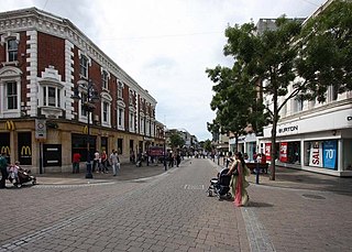
Gravesend is a town in northwest Kent, England, situated 21 miles (35 km) east-southeast of Charing Cross on the south bank of the River Thames and opposite Tilbury in Essex. Located in the diocese of Rochester, it is the administrative centre of the Borough of Gravesham.

Borough of Dartford Borough & Non-metropolitan district in England

The Borough of Dartford is a local government district in the north-west of the county of Kent, England. Its council is based in the town of Dartford. It is part of the contiguous London urban area. It borders the borough of Gravesham to the east, Sevenoaks District to the south, the London Borough of Bexley to the west, and the Thurrock unitary authority in Essex to the north, across the River Thames. The borough was formed on 1 April 1974 by the merger of the Municipal Borough of Dartford, the Swanscombe Urban District, and part of the Dartford Rural District. According to the 2011 Census, its population was 97,365.

Gravesham Borough & Non-metropolitan district in England

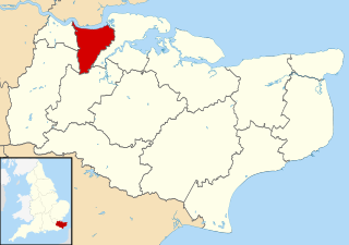
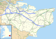
Gravesham is a local government district with borough status in north-west Kent, England. Its administrative centre and largest town is Gravesend, which was known as Gravesham in ancient times.

Cobham, Kent Human settlement in England

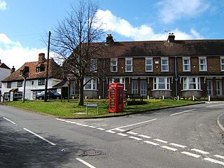
Cobham is a village and civil parish in the borough of Gravesham in Kent, England. The village is located 6 miles (10 km) south-east of Gravesend, and just south of Watling Street, the Roman road from Dover to London. The parish, which includes the hamlet of Sole Street, covers an area of 1,240 hectares and had a population of 1,469 at the 2011 Census, increasing from 1,328 at the 2001 Census.

Shorne Human settlement in England

Shorne is a village and civil parish in the borough of Gravesham in Kent, England. The parish lies 3 miles (4.8 km) east of Gravesend. Most of the land is well-drained but its marshes, the Shorne Marshes reach down to the Thames Estuary and are an SSSI amid the North Kent Marshes on the Hoo Peninsula proper.

Meopham Human settlement in England

Meopham is a large linear village and civil parish in the Borough of Gravesham in Kent, England, lying to the south of Gravesend. The parish covers 6.5 square miles (17 km2), and comprises two villages and two smaller settlements; it has a population of 6,427 increasing slightly to 6,722 at the 2011 census. Meopham village is sometimes described as the longest settlement in England although others such as Brinkworth, Wiltshire make the same claim. Meopham is one of the longest linear settlements in Europe, being 7 miles (11 km) in length.

Milton-next-Gravesend Ecclesiastical parish in Kent, England

Milton-next-Gravesend is an ecclesiastical parish in the north-west of Kent, England, which is now part of the Gravesend built-up area.

Chalk, Kent Human settlement in England

Chalk is a village and since 1935 a former civil parish which adjoins the east of Gravesend, Kent, England. As is intuitive, its name comes from the Saxon word cealc meaning a chalkstone. In 1931 the parish had a population of 563.

Gravesend–Tilbury Ferry

The Gravesend–Tilbury Ferry is a passenger ferry across the River Thames east of London. It is the last public crossing point before the Thames reaches the sea.

Singlewell or Ifield Human settlement in England

Singlewell or Ifield is the name given to the area south of Gravesend in Kent, England.

St Georges Church, Gravesend Anglican church in Kent, United Kingdom

St George's Church, Gravesend, is a Grade II*-listed Anglican church dedicated to Saint George the patriarch of England, which is situated near the foot of Gravesend High Street in the Borough of Gravesham. It serves as Gravesend's parish church and is located in the diocese of Rochester in Kent, England.

The Bat and Ball Ground Cricket and sports ground in Gravesend, Kent

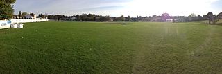
The Bat & Ball Ground is a cricket and sports ground in Gravesend in Kent. The ground was used as a first-class cricket venue by Kent County Cricket Club between 1849 and 1971. It remains in use by Gravesend Cricket Club who have used the ground as their home since their formation in 1881. The site also has lawn bowls and tennis facilities and is the home of Gravesend Bowls Club.

Town Pier, Gravesend

The Gravesend Town Pier is located in Gravesend, Kent. It was designed by William Tierney Clark and built in 1834 on the site of the earlier Town Quay. Over 3 million passengers were served between 1835 and 1842, but around 1900, this pier fell into disuse due to the arrival of the railways.

Shorne Wood Country Park

Shorne Wood Country Park is located between Strood and Gravesend, in the English county of Kent. It was once part of a large estate, later passed to the county council to be used as a country park.

Toltingtrough was a hundred in the Lathe of Aylesford in the county of Kent, England. This hundred is called, in some ancient writings, Toltetern and Tollentr, and in Domesday, Tollentru. In the return made of the several knights fees throughout England, by inquisition into the exchequer, in the 7th year of king Edward I, the archbishop of Canterbury appears to have been then lord of this Hundred.

Newark Town Hall Municipal building in Newark, Nottinghamshire, England

Newark Town Hall is a municipal building consisting of a town hall, assembly rooms and a market hall in Newark on Trent, Nottinghamshire, England. It is a Grade I listed building.

Maidstone Town Hall Municipal building in Maidstone, Kent, England

Maidstone Town Hall is a municipal building in Middle Row, Maidstone, Kent, England. The town hall, which is a meeting place of Maidstone Borough Council, is a Grade II* listed building.

Altrincham Town Hall Municipal building in Altrincham, Greater Manchester, England

Altrincham Town Hall is a municipal building in Market Street, Altrincham, Greater Manchester, England. The town hall was the headquarters of Altrincham Borough Council.

Deal Town Hall Municipal building in Deal, Kent, England

Deal Town Hall is a municipal building in the High Street in Deal, Kent, England. The town hall, which was the headquarters of Deal Borough Council, is a Grade II listed building.

Morpeth Town Hall Municipal building in Morpeth, Northumberland, England

Morpeth Town Hall is a municipal building in the Market Place, Morpeth, Northumberland, England. The structure, which was the meeting place of Morpeth Borough Council, is a Grade II listed building.

References

  1. 1 2 3 4 5 6 Historic England. "The Town Hall (1054761)". National Heritage List for England . Retrieved 6 March 2021.
  2. 1 2 3 "The Old Town Hall". Discover Gravesham. Retrieved 6 March 2021.
  3. 1 2 3 "History". Old Town Hall, Gravesend. Retrieved 6 March 2021.
  4. Hasted, Edward (1797). "'Parishes: Milton', in The History and Topographical Survey of the County of Kent". Canterbury: British History Online. pp. 335–346. Retrieved 6 March 2021.
  5. "The Grand Hall". Old Town Hall, Gravesend. Retrieved 6 March 2021.
  6. De Vries, G. Wingfield. A Pictorial History 1991 p.99 with photo ISBN   0620159391
  7. "Gravesend Chronology 1932-1937". Discover Gravesham. Retrieved 6 March 2021.
  8. "Site of the Civic Centre". Discover Gravesham. Retrieved 6 March 2021.
  9. "Gravesend Chronology 1967-1973". Discover Gravesham. Retrieved 6 March 2021.
  10. "Gravesend Chronology 1999-2000". Discover Gravesham. Retrieved 6 March 2021.
  11. "Row erupts at court scheme: Gravesend County Court may close in new plan". News Shopper. 27 March 2001. Retrieved 6 March 2021.
  12. "Gravesend Old Town Hall". Kent Venues. Retrieved 6 March 2021.
  13. "Gravesend". Gravesend Historical Society. Retrieved 6 March 2021.