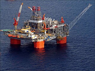
Petronius is a deepwater compliant tower oil platform built from 1997 to 2000 and operated by Chevron in the Gulf of Mexico, 210 km southeast of New Orleans, United States.
The Atlantis oil field is the third largest oil field in the Gulf of Mexico. The field was discovered in 1998 and is located at the Green Canyon blocks 699, 700, 742, 743, and 744 in United States federal waters in the Gulf of Mexico about 130 miles (210 km) from the coast of Louisiana. The oil field lies in water depths ranging from 4,400 to 7,100 feet. The subsea structure of Atlantis has long been the target of safety critics.
Thunder Horse oil field is a large offshore deepwater oil field in the Gulf of Mexico, around 150 miles (240 km) southeast of New Orleans, Louisiana. Large new oil discoveries within it were announced in early 2019.

Bullwinkle was a 1,736 feet (529 m) tall, pile-supported fixed steel oil platform in the Gulf of Mexico. Installed in 1988, the total weight of the platform was 77,000 tons, of which the steel jacket comprises 49,375 tones. At the time of its construction it was the third tallest freestanding structure ever built – shorter than only the CN Tower and the Ostankino Tower – and the tallest in the United States, being 6 ft (1.8 m) taller than the pinnacle of the Sears Tower. Of the total height, 1,352 feet (412 m) are below the waterline. It was located in Green Canyon Block 65, approximately 160 miles (260 km) southwest of New Orleans. Bullwinkle belongs to Fieldwood Energy LLC. The total field development construction cost was US$500,000,000 according to some sources.

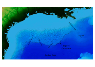
Mad Dog Oil Field is an offshore oil field located along the Sigsbee Escarpment at Green Canyon blocks 825, 826 and 782, Western Atwater Foldbelt, Gulf of Mexico. The field is located about 190 miles (310 km) south of New Orleans and 150 miles (240 km) southwest of Venice, Louisiana, United States. It is in the depth of 5,000 to 7,000 feet of water.

Deepwater Horizon was an ultra-deepwater, dynamically positioned, semi-submersible offshore drilling rig owned by Transocean and operated by BP. On 20 April 2010, while drilling at the Macondo Prospect, a blowout caused an explosion on the rig that killed 11 crewmen and ignited a fireball visible from 40 miles (64 km) away. The fire was inextinguishable and, two days later, on 22 April, the Horizon sank, leaving the well gushing at the seabed and causing the largest marine oil spill in history.
Noble Energy, Inc. was a company engaged in hydrocarbon exploration headquartered in Houston, Texas. In October 2020, the company was acquired by Chevron Corporation.

The U.S. offshore drilling debate is an ongoing debate in the United States on whether or not, the extent to which, in which areas, and under what conditions, further offshore drilling should be allowed in U.S.-administered waters.
The Mississippi Canyon is an undersea canyon, part of the Mississippi Submarine Valley in the North-central Gulf of Mexico, south of Louisiana. According to the U.S. Geological Survey GLORIA Mapping Program, it is the dominant feature of the north-central Gulf of Mexico. According to GCAGS Transactions, it has an average width of 8 kilometres (5.0 mi), and a length of 120 kilometres (75 mi). The US Minerals Management Service (MMS) applies the name Mississippi Canyon to numbered federal oil and gas lease blocks over a large offshore area centered on, but mostly outside, the submarine canyon.
The Tiber Oil Field is a deepwater offshore oil field located in the Keathley Canyon block 102 of the United States sector of the Gulf of Mexico. The deepwater field was discovered in September 2009 and it is operated by BP. Described as a "giant" find, it is estimated to contain 4 to 6 billion barrels of oil in place. Although BP states it is too early to be sure of the size – a "huge" field is usually considered to contain 250 million barrels. It required the drilling of a 10,685 m (35,056 ft) deep well under 1,260 m (4,130 ft) of water, making it one of the deepest wells ever drilled at the time of discovery.

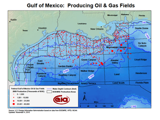
Offshore oil and gas in the Gulf of Mexico is a major source of oil and natural gas in the United States. The western and central Gulf of Mexico, which includes offshore Texas, Louisiana, Mississippi, and Alabama, is one of the major petroleum-producing areas of the United States. Oil production from US federal waters in the Gulf of Mexico reached an all-time annual high of 1.65 million barrels per day in 2017. Oil production is expected to continue the upward trend in 2018 and 2019, based on ten new oil fields which are planned to start production in those years. According to the Energy Information Administration, "Gulf of Mexico federal offshore oil production accounts for 15% of total U.S. crude oil production and federal offshore natural gas production in the Gulf accounts for 5% of total U.S. dry production."
The Macondo Prospect is an oil and gas prospect in the United States Exclusive Economic Zone of the Gulf of Mexico, off the coast of Louisiana. The prospect was the site of the Deepwater Horizon drilling rig explosion in April 2010 that led to a major oil spill in the region from the first exploration well, named itself MC252-1, which had been designed to investigate the existence of the prospect.
Atlantis PQ is a BP and BHP joint venture semi-submersible oil platform on permanent location over the Green Canyon Atlantis Oil Field in deepwater Gulf of Mexico, 190 mi (310 km) south of New Orleans. The "PQ" identifies the platform as being a production facility with crew quarters.
Thunder Horse PDQ is a BP plc and ExxonMobil joint venture semi-submersible oil platform on location over the Mississippi Canyon Thunder Horse oil field, in deepwater Gulf of Mexico, 150 miles (240 km) southeast of New Orleans, moored in waters of 1,840 metres (6,040 ft). The "PDQ" identifies the platform as being a Production and oil Drilling facility with crew Quarters.

Deepwater Nautilus is an ultra-deepwater, semi-submersible offshore drilling rig.
The Kaskida Oil Field is an offshore oil field located in the Keathley Canyon block 292 of the United States sector of the Gulf of Mexico, 250 miles (400 km) south-west of New Orleans, Louisiana. The field is operated by BP, and owned by BP (70%) and Devon Energy (30%).
Keathley Canyon is an undersea canyon in the United States Exclusive Economic Zone in the Gulf of Mexico. The canyon is named for the hydrographic survey ship USNS Sergeant George D. Keathley (T-AGS-35).
Olympus is a tension leg platform oil rig, planned as a further development of the Mars field.
Talos Energy Inc. is an oil and gas company that engages in the exploration, development, and production of oil and natural gas properties in the Gulf Coast and Gulf of Mexico.
Cindy A. Yeilding is an American geologist from Houston, Texas. Yeilding is Senior Vice President of British Petroleum, America. She was formerly Vice President of exploration technology and assurance, and has held various other positions at BP in oil and gas, exploration of the Gulf of Mexico and geoscience.
