
Cortez Municipal Airport is three miles southwest of Cortez, in Montezuma County, Colorado. It sees one airline, subsidized by the Essential Air Service program.

Pueblo Memorial Airport is a public airport located six miles east of Pueblo, in Pueblo County, Colorado, United States. It is primarily used for general aviation.
Taunton Municipal Airport, also known as King Field, is a public use airport located three nautical miles (6 km) east of the central business district of Taunton, a city in Bristol County, Massachusetts, United States. It is located in the East Taunton neighborhood of the city. The city-owned airport is maintained and operated by the Taunton Airport Commission. According to the FAA's National Plan of Integrated Airport Systems for 2009–2013, it is categorized as a general aviation airport.

Cleveland Burke Lakefront Airport is a public airport on the shore of Lake Erie, in the northeast part of downtown Cleveland, Ohio, United States. It classified as a general aviation airport and is an FAA designated reliever to Cleveland Hopkins International Airport (CLE), which is Greater Cleveland's primary airport. In 2008, based on FAA data, Burke Lakefront was the fourth busiest airport in the state of Ohio after Cleveland Hopkins, John Glenn Columbus International and Akron-Canton, up from 7th in 2007. It is named after former Cleveland mayor and U.S. senator Thomas A. Burke.
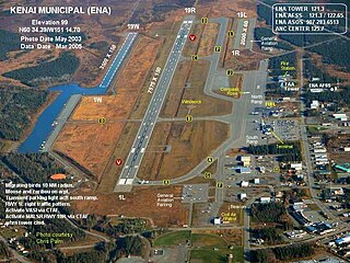
Kenai Municipal Airport is a city-owned, public-use airport located in Kenai, a city in the Kenai Peninsula Borough of the U.S. state of Alaska.

Iowa City Municipal Airport, is two miles southwest of Iowa City, in Johnson County, Iowa. It is the oldest civil airport west of the Mississippi River still in its original location.

Michigan City Municipal Airport is a public use airport located three nautical miles east of the central business district of Michigan City, in LaPorte County, Indiana, United States. The airport is publicly owned by the Michigan City Board of Aviation Commissioners.

Denton Enterprise Airport, also known as Denton Airport and previously Denton Municipal Airport, is a city-owned, public-use airport located three nautical miles (6 km) west of the central business district of Denton, a city in Denton County, Texas, United States.
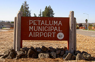
Petaluma Municipal Airport is a public airport one mile (1.6 km) northeast of Petaluma, in Sonoma County, California. The airport covers 220 acres (89 ha) and has one runway 3601 x 75 feet. It is used for general aviation. FedEx feeder flies Cessna Caravan 208Bs into Petaluma.

Orlando Apopka Airport is a privately owned, uncontrolled, public-use airport located four nautical miles (7 km) northwest of the central business district of Apopka, in Orange County, Florida, United States. It was previously known as Orlando Country Airport and McDonald Airport prior to that, the latter due its proximity to the unincorporated community of McDonald, Florida.
Atlantic Municipal Airport, is a city-owned public-use airport located two miles (3 km) west of the central business district of Atlantic, a city in Cass County, Iowa, United States. The airport has a runway opened in 2006 capable of handling light business jets.

Nampa Municipal Airport is a city-owned public airport in Nampa, in Canyon County, Idaho. The FAA's National Plan of Integrated Airport Systems for 2009–2013 called it a general aviation airport.

Marshfield Municipal Airport is a city owned public use airport located one nautical mile (2 km) south of the central business district of Marshfield, a city in Wood County, Wisconsin, United States. It is included in the Federal Aviation Administration (FAA) National Plan of Integrated Airport Systems for 2019–2023, in which it is categorized as a local general aviation facility.

Greenwood–Leflore Airport is a public airport seven miles east of Greenwood, the county seat of Leflore County, Mississippi. It is owned by the City of Greenwood and Leflore County, but is actually in Carroll County.

Olive Branch Airport is a privately owned, public use airport in De Soto County, Mississippi, United States. It is located three nautical miles (6 km) northeast of the central business district of Olive Branch, Mississippi. This airport included in the National Plan of Integrated Airport Systems for 2011–2015, which categorized it as a general aviation reliever airport.

DeKalb Taylor Municipal Airport which opened in April 1944, is a general aviation airport and is situated on 920 acres (3.7 km2) at an elevation of 914 ft and located two miles (3.2 km) east of DeKalb, Illinois, United States. DeKalb Taylor Municipal Airport is located approximately 60 mi (97 km) west of Chicago. The airport is open 24 hours a day and is owned by the city of DeKalb.
Miami Municipal Airport is a city-owned airport two miles northwest of Miami, in Ottawa County, Oklahoma. The National Plan of Integrated Airport Systems for 2011–2015 called it a general aviation facility.
Kokomo Municipal Airport is five miles northeast of Kokomo, in Howard County, Indiana. It is owned by the Kokomo Board of Aviation Commissioners. The FAA's National Plan of Integrated Airport Systems for 2009–2013 categorized it as a general aviation facility.
Crawfordsville Regional Airport is a public use airport located 4 miles (6.4 km) south of the central business district of Crawfordsville, a city in Montgomery County, Indiana, United States. The airport was founded in June 1945 and is owned by the city. It is included in the Federal Aviation Administration (FAA) National Plan of Integrated Airport Systems for 2019–2023, in which it is categorized as a local general aviation facility.
Frankfort Municipal Airport is a public airport located 3 miles (4.8 km) west of Frankfort, in Clinton County, Indiana, United States. The airport was founded in December 1960.


