
Posey County is a county located in the southwestern corner of the U.S. state of Indiana. Its southern border is formed by the Ohio River, and the western border by the Wabash River, a tributary. As of 2010, the population was 25,910. The county seat is Mount Vernon.

Jennings County is a county located in the U.S. state of Indiana. As of 2010, the population was 28,525. The county seat is Vernon.
Air Wisconsin Airlines is a regional airline based at Appleton International Airport in the town of Greenville, Wisconsin, United States, near Appleton. Air Wisconsin previously operated US Airways Express service on behalf of US Airways prior to becoming an American Eagle regional air carrier. As of March 2018, Air Wisconsin operates exclusively as a United Express regional air carrier with primary hubs to located at Chicago O'Hare International Airport (ORD) and Washington Dulles International Airport (IAD).

Indianapolis–Carmel–Anderson or Indianapolis metropolitan area is an 11-county metropolitan area in the U.S. state of Indiana, as defined by the Office of Management and Budget. The metropolitan area is situated in Central Indiana, within the American Midwest.
Indiana County–Jimmy Stewart Airport is a county-owned public airport two miles (3 km) east of the borough of Indiana, in Indiana County, Pennsylvania. The airport is about 65 miles (105 km) northeast of Pittsburgh and is in the Pittsburgh Combined Statistical Area. It is classified as a business service airport by the Pennsylvania Bureau of Aviation.

Northern Indiana is a region of the U.S. State of Indiana, including 26 counties which border the states of Illinois, Michigan, and Ohio. Northern Indiana is also considered part of the Great Lakes Megalopolis. The area is generally classified into other sub-regions; Northwest Indiana is closely tied with Chicago economically, culturally, and politically and is part of the Chicago metropolitan area. The north central region centers on South Bend metropolitan area, with economic connections to southwest Michigan. Northeast Indiana is centered on the Fort Wayne metropolitan area.
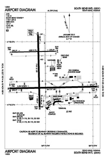
South Bend International Airport is three miles northwest of South Bend, in St. Joseph County, Indiana, United States. It is the state's third busiest airport in terms of passenger traffic after Indianapolis International Airport and Fort Wayne International Airport.

Indiana's 8th congressional district is a congressional district in the U.S. state of Indiana. Based in southwest and west central Indiana, the district is anchored in Evansville and also includes Jasper, Princeton, Terre Haute, Vincennes and Washington.
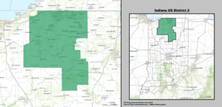
Indiana's 2nd congressional district is a legislative electoral area in north central Indiana. With a heavy white population, it includes South Bend and Elkhart.

Lincoln Dixon was a U.S. Representative from Indiana.
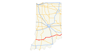
U.S. Route 50 (US 50) is a part of the United States Numbered Highway System that runs from West Sacramento, California, to Ocean City, Maryland. In the U.S. state of Indiana, it is part of the state road system. US 50 enters the state in Vincennes. The 171.38 miles (275.81 km) of US 50 that lie within Indiana serve as a major conduit. All of the highway is listed on the National Highway System. Various sections are rural two-lane highway, urbanized four-lane undivided highway and one-way streets. The easternmost community along the highway is Lawrenceburg at the Ohio state line. US 50 passes through urban areas, farmland and woodland.
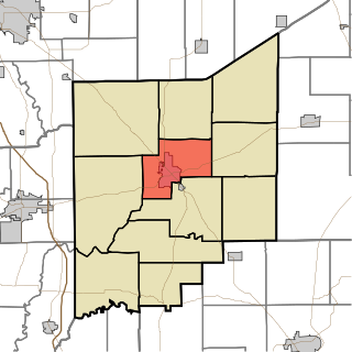
Center Township is one of eleven townships in Jennings County, Indiana, United States. As of the 2010 census, its population was 8,894 and it contained 3,795 housing units.
Vernon G. Smith is a Democratic member of the Indiana House of Representatives, representing the 14th District since 1990. He was the chair of the Indiana Black Legislative Caucus from 2006–2008.

The Southern Indiana Career & Technical Center is a high school-level institution that provides advanced education to meet the demand in the areas of agriculture, business and marketing, family and consumer sciences, health careers, and trade and industry arts to the students in Indiana's Area Career & Technical District #46 (ACTD-46) consisting of nine school district and corporations in Gibson, Posey, Spencer, Vanderburgh and Warrick Counties in Southwestern Indiana. 90.7 FM WPSR, which used to broadcast from Central High School, now broadcasts from the center.
Kovo or KOVO may refer to:

The Squaw Creek Southern Railroad is a Class III railroad subsidiary of Respondek Railroad operating in the southern portion of the State of Indiana. Originally, the Squaw Creek Southern started operating 21 miles of former Yankeetown Dock Corporation/Peabody Coal trackage owned by Norfolk Southern, but has since started servicing Foresight Energy's Sitran Coal Terminal near Evansville, Indiana and SABIC's Innovative Plastics plant in Mount Vernon, Indiana.

Indy South Greenwood Airport is a city-owned public-use airport in Greenwood, a city in Johnson County, Indiana, United States. It is 10 miles (16 km) southeast of Indianapolis. The airport was founded in September 1947 and is primarily used for general aviation. The airport has several on-field businesses. Jeff Air Pilot Services provides aircraft rental and pilot training under FAR Part 141, Groh Aviation provides aircraft maintenance and Trammel Air provides aircraft rental and flight instruction.
Peru Municipal Airport (I76) is a public airport 4 miles (6.4 km) northwest of Peru, in Miami County, Indiana. The airport was founded in March 1971.
Randolph County Airport (I22) is a public airport 3 miles (4.8 km) east of Winchester, in Randolph County, Indiana. The airport was founded in June 1948.
Wabash Municipal Airport is a public airport 3 nautical miles southeast of Wabash, in Wabash County, Indiana. The airport was founded in May 1958.


