
Columbus Municipal Airport is three miles north of Columbus, in Bartholomew County, Indiana, United States.
Fulton County Airport is two miles east of Rochester, in Fulton County, Indiana. It is owned by the Fulton County Airport Authority.
Porter County Regional Airport is a public use airport one mile (1.6 km) southeast of the central business district of Valparaiso, a city in Porter County, Indiana, United States. The Porter County Municipal Airport Authority owns the airport.
Michigan City Municipal Airport is a public use airport located three nautical miles east of the central business district of Michigan City, in LaPorte County, Indiana, United States. The airport is publicly owned by the Michigan City Board of Aviation Commissioners.
Elkhart Municipal Airport is a city-owned public-use airport located three nautical miles (6 km) northwest of the central business district of Elkhart, a city in Elkhart County, Indiana, United States.
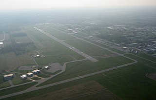
Delaware County Regional Airport is in Delaware County, Indiana three miles northwest of Muncie. Owned by the Delaware County Airport Authority, it was formerly Delaware County Airport and Johnson Field. The National Plan of Integrated Airport Systems for 2011–2015 categorized it as a general aviation facility.
Eagle Creek Airpark is a public use airport located seven nautical miles (13 km) west of the central business district of Indianapolis, a city in Marion County, Indiana, United States. It is owned by the Indianapolis Airport Authority and serves as a reliever airport for Indianapolis International Airport.
Daviess County Airport is a county-owned public-use airport located three nautical miles northeast of the central business district of Washington, a city in Daviess County, Indiana, United States.

Sullivan County Airport is a county-owned public-use airport located three nautical miles northwest of the central business district of Sullivan, a city in Sullivan County, Indiana, United States. It is included in the FAA's National Plan of Integrated Airport Systems for 2011–2015, which categorized it as a general aviation facility.
Shelbyville Municipal Airport is a public use airport located four nautical miles (7 km) northwest of the central business district of Shelbyville, in Shelby County, Indiana, United States. The airport is owned by the city of Shelbyville and is controlled by the mayor and an appointed Board of Commissioners. According to the FAA's National Plan of Integrated Airport Systems for 2009–2013, it was classified as a general aviation airport.
Huntington Municipal Airport is a city-owned, public-use airport located three nautical miles southeast of the central business district of Huntington, a city in Huntington County, Indiana, United States. According to the FAA's National Plan of Integrated Airport Systems for 2009–2013, it was classified as a general aviation airport.
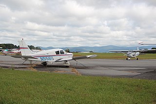
Pickens County Airport is a county-owned, public-use airport in Pickens County, Georgia, United States. It is located two nautical miles southwest of the central business district of Jasper, Georgia. As per the FAA's National Plan of Integrated Airport Systems for 2009-2013, it is classified as a general aviation airport.
Tri-State Steuben County Airport is a public use airport in Steuben County, Indiana, United States. Owned by the Steuben County Board of Aviation Commissioners, it is located three nautical miles (6 km) west of the central business district of Angola, Indiana. The airport is included in the National Plan of Integrated Airport Systems for 2011–15, which categorized it as a general aviation facility.
Marion County Airport, also known as Brown Field, is a county-owned, public-use airport located four nautical miles southeast of the central business district of Jasper, a town in Marion County, Tennessee, United States.

Kokomo Municipal Airport is five miles northeast of Kokomo, in Howard County, Indiana. It is owned by the Kokomo Board of Aviation Commissioners. The FAA's National Plan of Integrated Airport Systems for 2009–2013 categorized it as a general aviation facility.
Mettel Field is a public airport three miles north of Connersville, in Fayette County, Indiana. It is owned by the Connersville Board of Aviation Commissioners. The National Plan of Integrated Airport Systems for 2011–2015 categorized it as a general aviation facility.
Portland Municipal Airport is a city-owned, public-use airport located one nautical mile (2 km) northwest of the central business district of Portland, a city in Jay County, Indiana, United States. It is included in the National Plan of Integrated Airport Systems for 2011–2015, which categorized it as a general aviation facility.
New Castle-Henry County Municipal Airport is a public use airport located four nautical miles southeast of the central business district of New Castle, a city in Henry County, Indiana, United States. It is included in the National Plan of Integrated Airport Systems for 2011–2015, which categorized it as a general aviation facility.
White County Airport is a public use airport in White County, Indiana, United States. It is owned by the White County Board of Aviation Commissioners and located three nautical miles (6 km) south of the central business district of Monticello, Indiana. This airport is included in the National Plan of Integrated Airport Systems for 2011–2015, which categorized it as a general aviation facility.
Kentland Municipal Airport is a public use airport located one nautical mile (2 km) southeast of the central business district of Kentland, in Newton County, Indiana, United States. It is owned by the Kentland Board of Aviation Commissioners. This airport was included in the National Plan of Integrated Airport Systems for 2011–2015, which categorized it as a general aviation facility.


