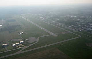
Porter County Regional Airport is a public use airport one mile (1.6 km) southeast of the central business district of Valparaiso, a city in Porter County, Indiana, United States. The Porter County Municipal Airport Authority owns the airport.
Michigan City Municipal Airport is a public use airport located three nautical miles east of the central business district of Michigan City, in LaPorte County, Indiana, United States. The airport is publicly owned by the Michigan City Board of Aviation Commissioners.

Perry–Houston County Airport is a public airport located four miles (6 km) northwest of the central business district of Perry, a city in Houston County, Georgia, United States and 10 miles (16 km) south of Warner Robins, Georgia. It is owned by the Perry–Houston County Airport Authority. It is used for general aviation, mainly flight training.
Elkhart Municipal Airport is a city-owned public-use airport located three nautical miles (6 km) northwest of the central business district of Elkhart, a city in Elkhart County, Indiana, United States.
Warsaw Municipal Airport is a public use airport located two miles (3 km) north of the central business district of Warsaw, a city in Kosciusko County, Indiana, United States. It is owned by the Warsaw Board of Aviation Commissioners.
Anderson Municipal Airport is a public use airport three miles east of Anderson in Madison County, Indiana. The National Plan of Integrated Airport Systems for 2011–2015 categorized it as a general aviation facility. The airport currently has no scheduled air service however, is one of the busiest general aviation airports in the State of Indiana given its high volume of flight training and charter traffic.
Mount Pleasant Municipal Airport is a city-owned public-use airport located two miles (3 km) northeast of the central business district of Mount Pleasant, a city in Isabella County, Michigan, United States. The airport became active in 1940. It serves general aviation for Mount Pleasant and the surrounding area. It is included in the Federal Aviation Administration (FAA) National Plan of Integrated Airport Systems for 2017–2021, in which it is categorized as a local general aviation facility.
Freeman Municipal Airport is a public use airport located two nautical miles (4 km) southwest of the central business district of Seymour, a city in Jackson County, Indiana, United States. It is owned by the Seymour Airport Authority. This airport is included in the National Plan of Integrated Airport Systems for 2021–2025, which categorized it as a general aviation facility.
Virgil I. Grissom Municipal Airport is a public use airport located three nautical miles southeast of the central business district of Bedford, a city in Lawrence County, Indiana, United States.
Shelbyville Municipal Airport is a public use airport located four nautical miles (7 km) northwest of the central business district of Shelbyville, in Shelby County, Indiana, United States. The airport is owned by the city of Shelbyville and is controlled by the mayor and an appointed Board of Commissioners. According to the FAA's National Plan of Integrated Airport Systems for 2009–2013, it was classified as a general aviation airport.
Huntington Municipal Airport is a city-owned, public-use airport located three nautical miles southeast of the central business district of Huntington, a city in Huntington County, Indiana, United States. According to the FAA's National Plan of Integrated Airport Systems for 2009–2013, it was classified as a general aviation airport.
Perry Municipal Airport is a city-owned public-use airport located three nautical miles west of the central business district of Perry, a city in Dallas County, Iowa, United States. This airport is included in the FAA's National Plan of Integrated Airport Systems for 2015–2019, which categorized it as a general aviation facility.

Kokomo Municipal Airport is five miles northeast of Kokomo, in Howard County, Indiana. It is owned by the Kokomo Board of Aviation Commissioners. The FAA's National Plan of Integrated Airport Systems for 2009–2013 categorized it as a general aviation facility.

Goshen Municipal Airport is a public-use civil airport three miles southeast of Goshen, in Elkhart County, Indiana. It is owned by the Goshen Board of Aviation Commissioners. The National Plan of Integrated Airport Systems for 2011–2015 categorized it as a general aviation facility.
Portland Municipal Airport is a city-owned, public-use airport located one nautical mile (2 km) northwest of the central business district of Portland, a city in Jay County, Indiana, United States. It is included in the National Plan of Integrated Airport Systems for 2011–2015, which categorized it as a general aviation facility.
Plymouth Municipal Airport is a public use airport located two nautical miles (4 km) north of the central business district of Plymouth, a city in Marshall County, Indiana, United States. It is owned by the Plymouth Board of Aviation of Commissioners. This airport is included in the National Plan of Integrated Airport Systems for 2011–2015, which categorized it as a general aviation facility.
New Castle-Henry County Municipal Airport is a public use airport located four nautical miles southeast of the central business district of New Castle, a city in Henry County, Indiana, United States. It is included in the National Plan of Integrated Airport Systems for 2011–2015, which categorized it as a general aviation facility.
Kentland Municipal Airport is a public use airport located one nautical mile (2 km) southeast of the central business district of Kentland, in Newton County, Indiana, United States. It is owned by the Kentland Board of Aviation Commissioners. This airport was included in the National Plan of Integrated Airport Systems for 2011–2015, which categorized it as a general aviation facility.
Appleton Municipal Airport, is a public use airport located 2 miles (3 km) northeast of the central business district of Appleton, a city in Swift County, Minnesota, United States. The closest airport with commercial airline service is Watertown Regional Airport about 60 miles (97 km) to the southwest.

