The Northern Territory is an Australian internal territory in the central and central-northern regions of Australia. The Northern Territory shares its borders with Western Australia to the west, South Australia to the south, and Queensland to the east. To the north, the Northern Territory looks out to the Timor Sea, the Arafura Sea and the Gulf of Carpentaria, including Western New Guinea and various other islands of the Indonesian archipelago.

The protected areas of the Northern Territory consists of protected areas managed by the governments of the Northern Territory and Australia and private organisations with a reported total area of 335,527 square kilometres (129,548 sq mi) being 24.8% of the total area of the Northern Territory of Australia.

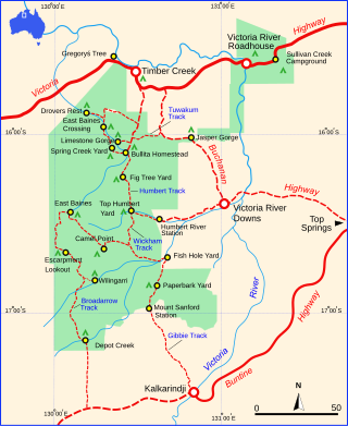
Judbarra National Park, formerly Gregory National Park and Judbarra / Gregory National Park, is a national park in the Northern Territory of Australia, 359 km (223 mi) south of Darwin.
Litchfield National Park, covering approximately 1500 km2, is near the township of Batchelor, 100 km south-west of Darwin, in the Northern Territory of Australia. Each year the park attracts over 260,000 visitors.

Karlu Karlu / Devils Marbles Conservation Reserve is a protected area in the Northern Territory of Australia located in the locality of Warumungu about 105 km (65 mi) south of Tennant Creek, and 393 km (244 mi) north of Alice Springs. The nearest settlement is the small town of Wauchope located 9 km (5.6 mi) to the south. The hamlet of Wycliffe Well is located 25 km (16 mi) to the south.

Adansonia gregorii, commonly known as the boab and also known by a number of other names, is a tree in the family Malvaceae, endemic to the northern regions of Western Australia and the Northern Territory of Australia.

Sir Augustus Charles Gregory was an English-born Australian explorer and surveyor. Between 1846 and 1858 he undertook four major expeditions. He was the first Surveyor-General of Queensland. He was appointed a lifetime Member of the Queensland Legislative Council.

Kings Canyon, also known as Watarrka, is a canyon in the Northern Territory of Australia located at the western end of the George Gill Range about 321 kilometres (199 mi) southwest of Alice Springs and about 1,316 kilometres (818 mi) south of Darwin, within the Watarrka National Park.

Renner Springs is a location in the Northern Territory of Australia. It is in the heart of the Barkly Tablelands cattle country. In fact, the town promotes itself as "The Heart of the Beef Country."

The Victoria River is a river in the bioregion of Victoria Bonaparte in the Northern Territory of Australia. It flows for 560 kilometres (350 mi) from its source south of the Judbarra / Gregory National Park to the Joseph Bonaparte Gulf in the Timor Sea.

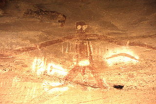
An Australian Aboriginal sacred site is a place deemed significant and meaningful by Aboriginal Australians based on their beliefs. It may include any feature in the landscape, and in coastal areas, these may lie underwater. The site's status is derived from an association with some aspect of social and cultural tradition, which is related to ancestral beings, collectively known as Dreamtime, who created both physical and social aspects of the world. The site may have its access restricted based on gender, clan or other Aboriginal grouping, or other factors.

The Bradshaw Field Training Area (BFTA) is a large army training area located 600 km (370 mi) south of Darwin in the Northern Territory of Australia. It is used for training by the Australian Army, and as an Australia-U.S. combined training centre with the U.S. Marines stationed at Darwin.

The buff-sided robin is a small, diurnal, insectivorous, perching (passerine) bird in the family Petroicidae, a group commonly known as the Australo-Papuan or Australasian robins. It is also known as the buff-sided fly-robin, buff-sided shrike-robin and Isabellflankenschnäpper (German). The buff-sided robin is endemic to northern Australia, where it primarily occurs in riparian forests and monsoon vine thickets from the Kimberly region of Western Australia to the north-west Queensland Gulf of Carpentaria. The plumage of the adult birds is characterised by a dark hood and back with a prominent white stripe on the supercilium; a white throat, white wing and tail bars, and a striking buff to orange patch on the flank below the wings. Adult birds are not sexually dimorphic; however, males are generally larger and can be separated from females based on morphological measurements. Buff-sided robins predominantly take insects from the ground by sallying from an observational perch. Insect prey are also occasionally taken by hawking on the wing or by gleaning from the trunk or foliage of riparian vegetation.
Timber Creek, traditionally known as Makalamayi, is an isolated small town on the banks of the Victoria River in the Northern Territory of Australia. The Victoria Highway passes through the town, which is the only significant settlement between the Western Australia border and the town of Katherine to the east. Timber Creek is approximately 600 kilometres (370 mi) south of Darwin, in an area known for its scenic escarpments and boab trees.

Arltunga Historical Reserve, known also as Arnerre-ntyenge is a deserted gold rush town located in the Northern Territory of Australia in the locality of Hart about 110 kilometres (68 mi) east of Alice Springs. It is on the lands of the Eastern Arrernte people who are the traditional owners.

The Tennant Creek Telegraph Station is an historical site about 16 kilometres north of Tennant Creek in the Northern Territory of Australia.

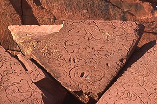
N'Dhala Gorge Nature Park is a protected area in the Northern Territory of Australia consisting of an area of low sand dunes, rocky outcrops, about 90 kilometres (56 mi) east of Alice Springs. It is significant principally because of thousands of Indigenous rock carvings.

John Flynn's Grave Historical Reserve, more commonly referred to as Flynn's Grave is the grave site of John Flynn who was an Australian Presbyterian minister who founded the Australian Inland Mission (AIM) and founding the Royal Flying Doctor Service. The grave, which is now a historical reserve, is located at the base of Mount Gillen on Larapinta Drive in the Alice Springs suburb of Flynn.
Baines is a locality in the Northern Territory of Australia located in the territory's west adjoining the border with the state of Western Australia about 421 kilometres (262 mi) south of the territory capital of Darwin and about 359 kilometres (223 mi) south-west of the municipal seat in Katherine.

Attack Creek Historical Reserve is a protected area in the Northern Territory and it is situated 74 kilometres (46 mi) north of Tennant Creek on the Stuart Highway. It is a small reserve, consisting of 0.22 hectares (2,200 m2) which contains the Attack Creek Historical Reserve Memorial, this is also known as the Stuart Memorial.


