Ruby Gap Nature Park

Last updated

Cliff lines in Ruby Gap Nature Park, 2009 Cliff lines in Ruby Gap Nature Park.jpg
Cliff lines in Ruby Gap Nature Park, 2009

Ruby Gap Nature Park or Tyweltherreme is a protected area in the Northern Territory consisting of 9,257 hectares and access to it is through Arltunga Historical Reserve. [1] [2] [3]

Contents

The park is 150 kilometres from Alice Springs and is the site of Central Australia's first mining rush from 1886. [1] [4] This discovery was shortly before David Lindsay's discovery of gold at Arltunga, 45 kilometers to the west. By May 1888 there were over 260 people in the area prospecting for rubies at the site. [4] [5] [6]

At the beginning of this ruby rush flooded the market for rubies and soon questions arose as to their quality. By June 1888 it was found that the stones being mined were high quality garnets and not rubies. These were of considerably less value then rubies and the market crashed. [4]

The Traditional Owners of this Country are the Eastern Arrernte people (Ulpmerre arenye) and it is a part of the Ulpmerre estate. [3]

History

In March 1886 explorer David Lindsay found what he thought were rubies at what became known as Ruby Gap in the bed of the Hale River (Lhere Altera/Arletherre) [7] [3] and he wrote in his diary on 8 March 1886 that he had discovered a granite bar "completely studded with garnets or rubies". [8]

Later, in a report to the Royal Geographical Society of Australasia he wrote in more detail saying: [9]

Still travelling eastward we found water in the sand in a few places, and tin in a granite hill, also a bar of granite completely studded with garnets crossing the creek. Just above this point, when scratching for water under a rocky cliff, I found some quantity of beautiful gem sand, containing many garnets and some red stones of great brilliancy, which, after careful examination, I believe to be rubies.

David Lindsay, Explorations in the Northern Territory of South Australia (1888), The Royal Geographical Society of Australiasia, South Australian Branch

As a part of this discovery he also named a nearby gorge Glen Annie gorge after his wife. [9] [7]

Alternatively, one of the other members of the party, Arthur Warman, claimed that it was he that made the initial discovery of the gems. It was then Warman who took them to a jeweler who said that they were rubies. Warman quickly made mining claims at Ruby Gap (applications dated 4 April 1887) and formed a mining syndicate which later formed into a company known as the MacDonnell Ranges Ruby Mining Company Ltd. [10] [8] In April 1887 the eight members of the syndicate travelled together to Ruby Gap and reached there on 23 May 1887 and, within two weeks, they collected between 30,000 and 40,000 gems. Richard Pearson, who would become the public face of the syndicate, claimed in a newspaper article, that one single gem found was worth £8,000 and that the total value of all gems found was £60,000. [11] The party arrived back in Adelaide on 15 July 1887 and the day following their return they made applications for further mining leases and to more clearly define their claim boundaries. [8]

Shortly after their return Pearson sailed to London on 11 August 1887 with a large number of stones to obtain expert opinion on their value, on this trip he also accepted an offer of £200,000 from British speculators for the leases which fell through when it was discovered that they were not, in fact, rubies. [10] News that the gems were not rubies, and were in fact high quality garnets, was spread by Edward Rennie, the president of the Royal Society of South Australia, in his report "On some so-called South Australian rubies" which he read to a gathering of the Society; these were then published in 1889. [10] [12] [13] This followed extended debates between a number of experts and was seen as the final word on the matter and news broke around the ruby field on 24 May 1888. [8]

Anecdotal accounts talk of a sudden exodus from the field and, by June 1888, applications for claims had come to an abrupt end and many of the miners went on to the nearby Arltunga gold fields. [8] Ernestine Hill wrote about the ruby rush in The Territory (1951) and she was not convinced that they were not rubies and called them "Alice Springs rubies" (a distinct variety) and said that, following the collapse of the market, the first prospectors would keep sugar bags full of rubies in their chicken houses for years and give them away by the handful to friends and relations. [14]

Frederick Fox grave

Within the Ruby Gap Nature Park is the grave of FH Fox, a miner and manager of the MacDonnell Ranges Ruby Mining Company, who died on 25 May 1888; this was the day following the announcement that the rubies had been redefined as garnets. [8] The death was reported to Alice Springs police on 5 June 1888 who listed the cause of death as being from illness; Walter Smith later claimed that, after finding himself destitute Fox had shot himself and that the police were being kind in not saying so. [15] [16] [17]

The grave is colloquially known as "Fox's Grave" and it is the destination of a popular walking track within the park. [7] [18] It is one of the only overt relics of the ruby rush in the region, however, it is likely that the current headstone is not the location of the original gravesite. [15]

The grave reads: "sacred to the memory of FH Fox, died May 25th 1888, aged 55 years". [16]

Others also died in the area during the ruby rush including Achta Mahomed (an Afghan cameleer) on 11 May 1888 and Alexander Murdoch. [19] [20]

Related Research Articles

<span class="mw-page-title-main">Northern Territory</span> Territory of Australia

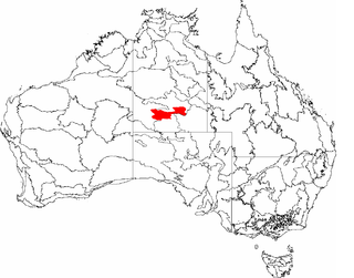
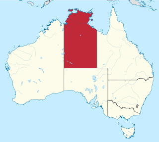
The Northern Territory is an Australian territory in the central and central northern regions of Australia. The Northern Territory shares its borders with Western Australia to the west, South Australia to the south, and Queensland to the east. To the north, the territory looks out to the Timor Sea, the Arafura Sea and the Gulf of Carpentaria, including Western New Guinea and other islands of the Indonesian archipelago.

<span class="mw-page-title-main">Ruby</span> Variety of corundum, mineral, gemstone

Ruby is a pinkish red to blood-red colored gemstone, a variety of the mineral corundum. Ruby is one of the most popular traditional jewelry gems and is very durable. Other varieties of gem-quality corundum are called sapphires. Ruby is one of the traditional cardinal gems, alongside amethyst, sapphire, emerald, and diamond. The word ruby comes from ruber, Latin for red. The color of a ruby is due to the element chromium.

<span class="mw-page-title-main">Protected areas of the Northern Territory</span>

The protected areas of the Northern Territory consists of protected areas managed by the governments of the Northern Territory and Australia and private organisations with a reported total area of 335,527 square kilometres (129,548 sq mi) being 24.8% of the total area of the Northern Territory of Australia.

<span class="mw-page-title-main">Alice Springs</span> Town in the Northern Territory, Australia

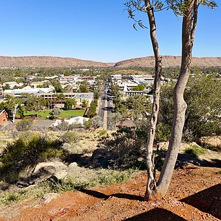
Alice Springs is a town in the Northern Territory, Australia; the third largest settlement after Darwin and Palmerston. The name Alice Springs was given by surveyor William Whitfield Mills after Alice, Lady Todd, wife of the telegraph pioneer Sir Charles Todd. Known colloquially as The Alice or simply Alice, the town is situated roughly in Australia's geographic centre. It is nearly equidistant from Adelaide and Darwin.

<span class="mw-page-title-main">Pine Creek, Northern Territory</span> Town in the Northern Territory, Australia

Pine Creek is a small town in the Katherine region of the Northern Territory, Australia and is situated just off the Stuart Highway; it is 90kms north of Katherine. As at the 2021 Census there were 318 residents of Pine Creek, which is the fourth largest town between Darwin and Alice Springs.

<span class="mw-page-title-main">MacDonnell Ranges</span> Mountain range in the Northern Territory, Australia

The MacDonnell Ranges, or Tjoritja in Arrernte, is a mountain range located in southern Northern Territory. MacDonnell Ranges is also the name given to an interim Australian bioregion broadly encompassing the mountain range, with an area of 3,929,444 hectares. The range is a 644 km (400 mi) long series of mountains in central Australia, consisting of parallel ridges running to the east and west of Alice Springs. The mountain range contains many spectacular gaps and gorges as well as areas of Aboriginal significance.

Mining is an important industry in Pakistan. Pakistan has deposits of several minerals including coal, copper, gold, chromite, mineral salt, bauxite and several other minerals. There are also a variety of precious and semi-precious minerals that are also mined. These include peridot, aquamarine, topaz, ruby, emerald, rare-earth minerals bastnaesite and xenotime, sphene, tourmaline, and many varieties and types of quartz.

<span class="mw-page-title-main">Australian gold rushes</span> Mass movement of Australians seeking gold (1851–1910s)

During the Australian gold rushes, starting in 1851, significant numbers of workers moved from elsewhere in Australia and overseas to where gold had been discovered. Gold had been found several times before, but the colonial government of New South Wales had suppressed the news out of the fear that it would reduce the workforce and destabilise the economy.

<span class="mw-page-title-main">Western Australian gold rushes</span> Gold prospecting in Western Australia

In the latter part of the nineteenth century, discoveries of gold at a number of locations in Western Australia caused large influxes of prospectors from overseas and interstate, and classic gold rushes. Significant finds included:

<span class="mw-page-title-main">Arltunga Historical Reserve</span> Protected area in the Northern Territory, Australia

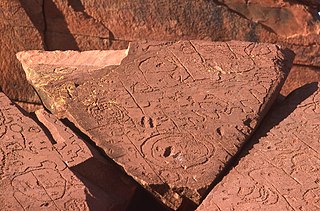
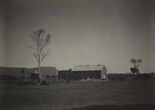
Arltunga Historical Reserve, known also as Arnerre-ntyenge is a deserted gold rush town located in the Northern Territory of Australia in the locality of Hart about 110 kilometres (68 mi) east of Alice Springs. It is on the lands of the Eastern Arrernte people who are the Traditional Owners.

<span class="mw-page-title-main">Mining in the Northern Territory</span>

Mining in the Northern Territory accounts for 16.4% of the gross domestic product, inclusive of both the minerals and petroleum industries. In 2015, it was valued at A$3,436 million. It accounts for 4.3% of the Northern Territory workforce. 63 businesses are currently engaged in the sector.

Walter Smith also known as Walter Purula (Perrurle) or Wati Yuritja was a legendary Australian bushman from the Arltunga region in the Northern Territory of Australia. Wati Yuritja translates as man of the Water Dreaming).

<span class="mw-page-title-main">Dick Kimber</span> Australian historian

Richard "Dick" Glyn Kimber is an Australian historian and author who has written extensively on the history, art, culture and wildlife of Central Australia. He has published several books, the best known of which is Man From Arltunga: Walter Smith, Australian Bushman as well as more than 100 articles and essays. Kimber is also a Member of the Order of Australia.

<span class="mw-page-title-main">Stuart Town Gaol</span> Prison in Alice Springs, Australia

Stuart Town Gaol in Alice Springs, Northern Territory, Australia, located on 9 Parson Street, was constructed in 1907, when Alice Springs had a European population of approximately 30 people, and held its first prisoner in 1909. It is one of the earliest permanent buildings constructed in the town and the first government building. The gaol follows a simple design and was built, using local materials, by stonemason Jack Williams.

<span class="mw-page-title-main">Gerhardt Johannsen</span>

Gerhardt Andreas Johannsen was a stonemason, builder and pastoralist in the Northern Territory.

William Garnet South was a police officer in Alice Springs and Chief Protector of Aborigines. He was also, for a short period, proprietor of the Stuart Arms Hotel in Alice Springs.

Ross Highway is a road in the Northern Territory, Australia located to the south of Alice Springs.

<span class="mw-page-title-main">Hale River</span> River in Northern Territory, Australia

The Hale River is a river in the southeast of Australia's Northern Territory. Most of the year, however, it has no water.

Anilios fossor, also known as the miner blind snake, is a species of blind snake that is endemic to Australia. The specific epithet fossor (“digger”) refers to the snake's fossorial habits as well as to the type locality.

<span class="mw-page-title-main">Winnecke Goldfield</span> Goldfield in Northern Territory, Australia

The Winnecke Goldfield, sometimes known as Winnecke Depot Goldfield, is a now abandoned goldfield about 70 kilometres north east of Alice Springs and 50 kilometres north west of Arltunga. It is located within the Central Desert Shire Council region. It is on the lands of the Eastern Arrernte people who are the Traditional Owners and it is within the within the estate known as Inerentye.

References

  1. 1 2 "Ruby Gap Nature Park". Northern Territory. Retrieved 27 May 2024.
  2. Government, Northern Territory (23 May 2024). "Ruby Gap Nature Park". nt.gov.au. Retrieved 27 May 2024.
  3. 1 2 3 "Ruby Gap Nature Park Joint Management Plan March 2021". Darwin: Legislative Assembly of the Northern Territory. hdl:10070/818047 . Retrieved 27 May 2024.
  4. 1 2 3 Parks and Wildlife Commission of the Northern Territory (1 January 2023). "Ruby Gap factsheet" (PDF). Northern Territory Parks. Retrieved 27 May 2024.
  5. "Miscellaneous". South Australian Register . Vol. LII, no. 12, 721. South Australia. 22 August 1887. p. 2 (Supplement to the South Australian Register.). Retrieved 27 May 2024 via National Library of Australia.
  6. "The Macdonnell Range ruby field". South Australian Weekly Chronicle . Vol. XXX, no. 1, 554. South Australia. 2 June 1888. p. 22. Retrieved 27 May 2024 via National Library of Australia.
  7. 1 2 3 "Ruby Gap & Glen Annie Gorge | Tourism Central Australia". www.discovercentralaustralia.com. Retrieved 27 May 2024.
  8. 1 2 3 4 5 6 Enever, Jim (1 October 2015). "'The rush that ended': the quest for rubies in Central Australia" (PDF). Australasian Mining History. Retrieved 27 May 2024.
  9. 1 2 Lindsay, David (1 January 1888). "Explorations in the Northern Territory of South Australia". Trove. Retrieved 27 May 2024.
  10. 1 2 3 Traynor, Stuart (2016), Alice Springs : from singing wire to iconic outback town, Wakefield Press, ISBN   978-1-74305-449-9
  11. "The discovery of a ruby mine". The South Australian Advertiser . Vol. XXX, no. 8975. South Australia. 25 July 1887. p. 6. Retrieved 27 May 2024 via National Library of Australia.
  12. Centre for Transformative Innovation, Swinburne University of Technology. "Journal Article - On some So-Called South Australian Rubies - Encyclopedia of Australian Science and Innovation". www.eoas.info. Retrieved 27 May 2024.
  13. "South Australian rubies". The Daily Telegraph . No. 3071. New South Wales, Australia. 25 May 1889. p. 5. Retrieved 27 May 2024 via National Library of Australia.
  14. Hill, Ernestine (1951), The Territory, Angus and Robertson, p. 203, ISBN   978-0-7254-0019-4
  15. 1 2 Forrest, Peter; Conservation Commission of the Northern Territory (1989), A report on a review of historic sites in Central Australia, Alice Springs and Barkly regions under the control of the Conservation Commission, Peter Forrest, retrieved 27 May 2024
  16. 1 2 Kimber, Richard (Richard G.) (1986), Man from Arltunga : Walter Smith, Australian bushman, Hesperian Press, p. 21, ISBN   978-0-85905-084-5
  17. "Death on the ruby field". The Port Augusta Dispatch, Newcastle And Flinders Chronicle . Vol. X, no. 900. South Australia. 5 June 1888. p. 2. Retrieved 27 May 2024 via National Library of Australia.
  18. "Plan of Management Ruby Gap Nature Park October 1993". hdl:10070/339018 . Retrieved 27 May 2024.
  19. Allwright, Barry (2005), Rivers of rubies : the history of the ruby rush in Central Australia, Barry M. Allwright, retrieved 27 May 2024
  20. "Latest telegrams (death of Alexander Murcdoch)". Northern Territory Times and Gazette . Vol. XIV, no. 781. Northern Territory, Australia. 20 October 1888. p. 3. Retrieved 27 May 2024 via National Library of Australia.

23°29′17″S135°01′12″E / 23.488°S 135.020°E / -23.488; 135.020