Gremmendorf

Last updated • 3 min readFrom Wikipedia, The Free Encyclopedia
Gremmendorf
Stadtteil of Münster
Location of Gremmendorf
Gremmendorf
Germany adm location map.svg
Red pog.svg
Gremmendorf
North Rhine-Westphalia location map 01.svg
Red pog.svg
Gremmendorf
Coordinates: 51°56′N07°40′E / 51.933°N 7.667°E / 51.933; 7.667 Coordinates: 51°56′N07°40′E / 51.933°N 7.667°E / 51.933; 7.667
Country Germany
State North Rhine-Westphalia
Admin. region Münster
District Urban district
City Münster
Elevation
60 m (200 ft)
Population
  Total11,000
Time zone UTC+01:00 (CET)
  Summer (DST) UTC+02:00 (CEST)
Vehicle registration MS
Website www.muenster.de

Gremmendorf is a locale in the city of Münster, North Rhine-Westphalia. [1] [2] The area lies south-eastern of the city-center, has a population of 11,000 (according to a December 31, 2009 census), and belongs to the south-eastern municipal district. Additionally, the locale is divided into two subvisions of Gremmendorf-West and Gremmendorf-East, of which the Gremmendorf-West subdivision is more central, and clearly larger by area. The locale of Gremmendorf encompasses the area of the Dortmund-Ems Canal to the large capelin and high bank.

Contents

History

Gremmendorf is probably less than 200 years old and is therefore one of the youngest locales in Münster. On a contemporary map of Münster from the year 1763, Gremmendorf is nowhere to be found. The locale is the result of a small settlement around the farmyard of Gremme in the Delstrup peasantry. The Delstrup, along with the Geist and Mecklenbeck peasantries belonged to the rural community of Lamberti, and the authority of Mauritz. Delstrup became incorporated into the urban area of Münster in 1903, due to the city's expansion. Due to this expansion on October 1, 1903, the Münster-Neubeckum route of the Westphalian state railway opened, with a stop at the Erbdrosten Way, which was later to be called Gremmendorf. In the years to come, the name Delstrup eventually faded out in favour of what it is known as today. The restaurant Waldesruh, known today as Haus Heuckmann, was first built in 1905 at Gremmendorfer Way, and in the same year was added to the then new train station as part of the same facility. In following years, barracks for Prussian military personnel were built around Gremmendorfer Way due to armed mobilization in preparation for the First World War. This effort was also supported by the transformation of the Loddenheide from an industrial area to a military base, as well as the building of Luftnachrichtenkaserne 1936 ( radio transmission outpost 1936), at Albersloher Way. Ever since 1920, one differentiates Old-Gremmendorf (farmyards around Erbdrosten Way) and New-Gremmendorf in lieu of new settlement around Gremmendorfer Way. After the Second World War, the barracks originally intended for German soldiers were taken over and utilized by British occupational forces as part of Osnabrück Garrison. (Following the defeat of Nazi Germany, the country was divided into 4 separate sectors: American, French, British, and Soviet; the Soviet area would eventually be known as East Germany). Due to this, the residential density of Old-Gremmendorf sharply rose, especially around Albersloher Way. In 1975, Gremmendorf was officially assigned as part of the south-eastern municipal district.

Culture

Culturally, Gremmendorf offers a community association, known as K.-G. Pängelanton. Connected to the association are the Niederdeutsche Heimat-Bühne (a theatrical group performing plays in the Low German dialect), and a sports club, SC Gremmendorf since 1946. Current notable figures include Heinrich Löwe, as founder, and Hermann Treff, as longtime chairman of the locale’s prestigious gun club, Otto Hersing, a U-Boot captain of the First World War, as well as Franz and Josef Horstmann as co-founders of SC Gremmendorf since 1946. Gremmendorf’s largest church community is the Roman Catholic St. Ida Gemeinde, who’s church is situated at Anton-Knubel Way.

Particularities

There isn’t a single independent street in Gremmendorf. Almost all roads end in Way, as likely observed in above paragraphs.

Sights

Locomotive Pangelanton, belonging to the railway history museum of the same name Munster, Gremmendorf, Pangelanton -- 2020 -- 9562.jpg
Locomotive Pängelanton, belonging to the railway history museum of the same name

Next to the long shopping street in the locale-center, is Gremmendorf’s main landmark. It is a classic steam locomotive, called Pängelanton, which is at the crossing of Albersloher and Erbdrosten Way. Gremmendorf is also known for the British York barracks, on Albersloher Way. The memorial at Gremmendorfer Way is a monument to the fallen soldiers of the Second World War. Every year, members of Gremmendorf’s community clubs, as well as members of the St. Ida Gemeinde gather for Volkstrauertag.

Related Research Articles

Münster Place in North Rhine-Westphalia, Germany

Münster is an independent city in North Rhine-Westphalia, Germany. It is in the northern part of the state and is considered to be the cultural centre of the Westphalia region. It is also a state district capital. Münster was the location of the Anabaptist rebellion during the Protestant Reformation and the site of the signing of the Treaty of Westphalia ending the Thirty Years' War in 1648. Today it is known as the bicycle capital of Germany.

Rheine Place in North Rhine-Westphalia, Germany

Rheine is a city in the district of Steinfurt in Westphalia, Germany. It is the largest city in the district and the location of Rheine Air Base.

Ballincollig Town in Munster, Ireland

Ballincollig is a suburban town within the administrative area of Cork city in Ireland. It is located on the western side of Cork city, beside the River Lee on the R608 regional road. In 2016 it was the largest town in County Cork, at which time the Ballincollig Electoral Division had a population of 18,621 people. The nearest towns include Ballinora, Carrigrohane, Kilnaglory, Ovens, Killumney, Inniscarra, Blarney, and Tower. It is located beyond the green belt from the suburbs of Bishopstown and Wilton. Ballincollig is within the Cork North-West Dáil constituency.

Castlemartyr Village in Munster, Ireland

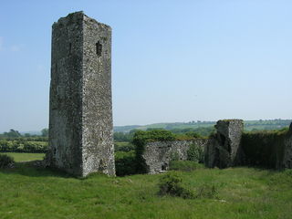
Castlemartyr is a village in East Cork, County Cork, Ireland. It is located 25 minutes east of Cork city, 10 km (6 mi) east of Midleton, 16 km (10 mi) west of Youghal and 6 km (4 mi) from the coast. Approximately 1,600 people live in the village and its hinterland. It is situated on the N25 national primary road.

Gütersloh Place in North Rhine-Westphalia, Germany

Gütersloh is a city in North Rhine-Westphalia, Germany, in the area of Westphalia and the administrative region of Detmold. Gütersloh is the administrative centre for a district of the same name and has a population of 100,194 people.

Bundesautobahn 1 Federal motorway in Germany

Bundesautobahn 1 is an autobahn in Germany. It runs from Heiligenhafen in Schleswig-Holstein to Saarbrücken, a distance of 749 km (465 mi), but is incomplete between Cologne and Trier. B 207 continues north from Heiligenhafen to Puttgarden, at the end of the island of Fehmarn, with a ferry to Rødby, Denmark.

Münster Osnabrück International Airport

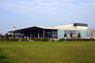
Münster Osnabrück International Airport, Flughafen Münster/Osnabrück in German, is a minor international airport in the German state of North Rhine-Westphalia. It is located near Greven, 25 km (16 mi) north of Münster and 35 km (22 mi) south of Osnabrück. The airport serves the area of the northern Ruhrgebiet, western and southwestern Lower Saxony, Emsland, Westphalia and parts of the Netherlands and features flights to some European city and leisure destinations.

Foreign concessions in Tianjin Former concession territories of Qing China

The foreign concessions in Tianjin were concession territories ceded by Qing China to a number of European countries, the United States and Japan within the city of Tianjin. There were altogether nine foreign concessions in old Tianjin on the eve of World War II. These concessions also contributed to the rapid development of Tianjin from the early to mid-20th century. The first foreign concessions in Tianjin were granted in 1860. By 1943, all the foreign concessions, save the Japanese concession, had ceased to exist de facto.

Dreisamstadion

Dreisamstadion is a football stadium in Freiburg, Baden-Württemberg, Germany. It is currently the home of Bundesliga team SC Freiburg. The stadium holds 24,000 spectators and was built in 1953. It is situated near the river Dreisam that it was named after.

Olching Place in Bavaria, Germany

Olching is a town in the district of Fürstenfeldbruck, in Bavaria, Germany. It is situated approximately 20 km (12 mi) northwest of Munich.

Vierkirchen Place in Bavaria, Germany

Vierkirchen is a municipality in the district of Dachau in Bavaria in Germany.

Winterlingen German municipality

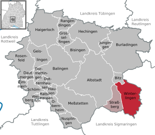
Winterlingen is a municipality in the Zollernalbkreis district of Baden-Württemberg, Germany.

Hörnum Place in Schleswig-Holstein, Germany

Hörnum  is a municipality in the district of Nordfriesland, in Schleswig-Holstein, Germany. It is located on the southern headland of the island of Sylt. The municipality is part of the Amt Landschaft Sylt. The economy is dominated by tourism.

Rattersdorf Village in Burgenland, Austria

Rattersdorf is an Austrian hamlet about 90 km south of Vienna, with a population of under 500. It is in the municipality of Mannersdorf an der Rabnitz, Oberpullendorf district, Burgenland state. Until 1899 the village was officially known by the more abbreviated name of Rőt.

Schneller Orphanage German Protestant orphanage that operated in Jerusalem from 1860 to 1940

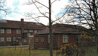
Schneller Orphanage, also called the Syrian Orphanage, was a German Protestant orphanage that operated in Jerusalem from 1860 to 1940.

Hoetmar Ortsteil of Warendorf in North Rhine-Westphalia, Germany

Hoetmar is a village that is located in North Rhine-Westphalia, Germany. More specifically, Hoetmar is nestled in between the towns of Sendenhorst, Everswinkel and Ennigerloh in agriculturally oriented Münsterland. Since 1974 it is under the administration of the town of Warendorf.

Bordon and Longmoor Military Camps

Bordon and Longmoor Military Camps are British Army training camps close to the A3 and A325 roads in and around the settlements of Bordon, Longmoor, Liss and Liphook in Hampshire, England. The main street of the Longmoor part of the camp is built on an ancient Roman road, the Chichester to Silchester Way, while the village of Greatham lies to the west. The combined camp and training area coveres 1,783 hectares of wooded areas, heath, wetlands and hard standings. Longmoor camp and the training areas are still active, and maintained by the Defence Infrastructure Organisation.

Harthof

Harthof is a district in the north of the Bavarian capital Munich. It is located in districts 11 Milbertshofen-Am Hart and 24 Feldmoching-Hasenbergl. Harthof consists of medium-sized housing estates and an estate of older council flats. The Harthofanger green area is located within.

References

  1. "Archived copy" (PDF). Archived from the original (PDF) on 2012-06-04. Retrieved 2012-08-13.CS1 maint: archived copy as title (link)
  2. "Münster in Westfalen: Wolbeck, Gremmendorf, Angelmodde". muenster.de. Archived from the original on 2012-07-02. Retrieved 2012-08-13.