
The Tyne Bridge is a through arch bridge over the River Tyne in North East England, linking Newcastle upon Tyne and Gateshead. The bridge was designed by the engineering firm Mott, Hay and Anderson, who later designed the Forth Road Bridge, and was built by Dorman Long and Co. of Middlesbrough. The bridge was officially opened on 10 October 1928 by King George V and has since become a defining symbol of Tyneside. It is ranked as the tenth tallest structure in Newcastle.
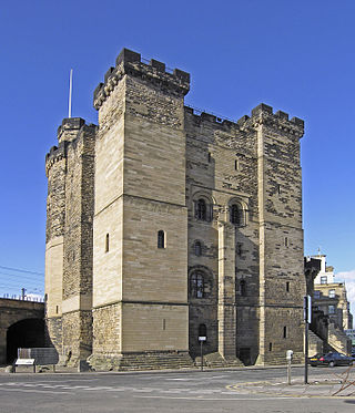
The Castle, Newcastle, or Newcastle Castle is a medieval fortification in Newcastle upon Tyne, England, built on the site of the fortress that gave the City of Newcastle its name. The most prominent remaining structures on the site are the Castle Keep, and the Black Gate, its fortified gatehouse.
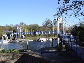
Richmond Lock and Footbridge is a lock, rising and falling low-tide barrage integrating controlled sluices and pair of pedestrian bridges on the River Thames in southwest London, England, and is a Grade II* listed structure. It is the furthest downstream of the forty-five Thames locks and the only one owned and operated by the Port of London Authority. It was opened in 1894 and is north-west of the centre of Richmond in a semi-urban part of southwest London. Downstream are Syon Park and Kew Gardens on opposite banks. It connects the promenade at Richmond with the neighbouring district of St. Margarets on the west bank during the day and is closed at night to pedestrians – after 19:30 GMT or after 21:30 when BST is in use. At high tide the sluice gates are raised and partly hidden behind metal arches forming twin footbridges.

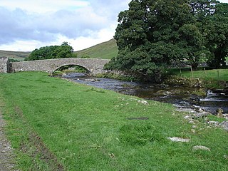
A packhorse bridge is a bridge intended to carry packhorses across a river or stream. Typically a packhorse bridge consists of one or more narrow masonry arches, and has low parapets so as not to interfere with the panniers borne by the horses. Multi-arched examples sometimes have triangular cutwaters that are extended upward to form pedestrian refuges.

Bellingham is a village and civil parish in Northumberland, to the north-west of Newcastle upon Tyne and is situated on the Hareshaw Burn at its confluence with the River North Tyne. In 2011 the parish had a population of 1334.
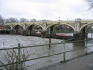
The Teddington Lock Footbridges are two footbridges over the River Thames in England, situated just upstream of Teddington Lock at Teddington. There is a small island between the bridges.

Wylam is a railway station on the Tyne Valley Line, which runs between Newcastle and Carlisle via Hexham. The station, situated 9 miles 71 chains west of Newcastle, serves the village of Wylam in Northumberland, England. It is owned by Network Rail and managed by Northern Trains.

Prudhoe is a railway station on the Tyne Valley Line, which runs between Newcastle and Carlisle via Hexham. The station, situated 12 miles 1 chain west of Newcastle, serves the town of Prudhoe and villages of Mickley and Ovingham in Northumberland, England. It is owned by Network Rail and managed by Northern Trains.

Hexham is a railway station on the Tyne Valley Line, which runs between Newcastle and Carlisle via Hexham. The station, situated 22 miles 22 chains west of Newcastle, serves the market town of Hexham in Northumberland, England. It is owned by Network Rail and managed by Northern Trains.
River Skirfare is a small river in North Yorkshire, England, that flows through Littondale and ends where it joins the larger River Wharfe. The source is the confluence of Foxup Beck and Cosh Beck at the hamlet of Foxup.

Wylam Railway Bridge is a footbridge and former railway bridge crossing the River Tyne at Hagg Bank, approximately 1⁄2 mile (0.8 km) west of Wylam in Northumberland, England.

Linton is a village and civil parish in the Craven district of North Yorkshire, England. The population as of the 2011 census was 176. It lies not far from Grassington, just south of the River Wharfe, and is 7 miles (11 km) north of Skipton. Linton Beck runs through the village and then joins the Wharfe at Linton Falls. The beck is crossed by two Grade II listed bridges on the village green, and is overlooked by Fountaine's Hospital, a Grade II* listed chapel and almshouse built in the style of Sir John Vanburgh. There is also a public house, the Fountaine Inn.

Tynemouth is a Tyne and Wear Metro station, serving the coastal town of Tynemouth, North Tyneside in Tyne and Wear, England. It joined the network as a terminus station on 11 August 1980, following the opening of the first phase of the network, between Haymarket and Tynemouth via Four Lane Ends.

The Tyne Valley Line is a 58-mile (93 km) route, linking Newcastle upon Tyne with Hexham and Carlisle, England. The line follows the course of the River Tyne through Tyne and Wear and Northumberland. Five stations and two viaducts on the route are listed structures.

Teesquay Millennium Footbridge is a footbridge crossing east-west over the River Tees between Stockton high street and Thornaby in Northern England. It is just east of Stockton town centre and in the town's namesake borough.

Corby Bridge is a railway viaduct adjacent to and immediately east of Wetheral railway station at Wetheral, near Carlisle, in north-western England, begun in 1830 and completed in 1834. It is 920 feet (280 m) long and 100 feet (30 m) high, and has been a Grade I listed building since 1 April 1957.

Old Haydon Bridge is a footbridge across the River South Tyne providing access between the Northern and Southern sides of the village of Haydon Bridge, Northumberland, England.

Tadcaster Bridge or Wharfe Bridge spans the River Wharfe in Tadcaster, North Yorkshire, England. The road bridge is believed to date from around 1700. It is the main route connecting the two sides of the town and one of two road crossings in the town, the other being the bridge for the A64 bypass. Tadcaster Bridge partially collapsed on 29 December 2015 after flooding that followed Storm Eva, and reopened on 3 February 2017.

Falstone Bridge is a stone bridge across the River North Tyne at Falstone in Northumberland.
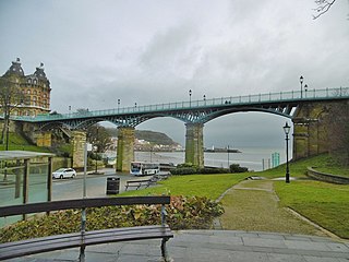
The Cliff Bridge, previously known as the Spa Bridge, is a footbridge in Scarborough, North Yorkshire, England. Spanning the valley from St Nicholas Cliff to The Spa, it was completed in 1827 and is a Grade II listed building.

