
George Westinghouse Memorial Bridge in East Pittsburgh, Pennsylvania, carries U.S. Route 30, the Lincoln Highway, over the Turtle Creek Valley near to where it joins the Monongahela River Valley east of Pittsburgh. The reinforced concrete open-spandrel deck arch bridge has a total length of 1,598 feet (487 m) comprising five spans. The longest, central span is 460 feet (140 m), with the deck height 240 feet (73 m) above the valley floor, for a time the world's longest concrete arch span structure. It cost $1.75 million. The design engineers were Vernon R. Covell and George S. Richardson, with architectural design by Stanley Roush. The pylons at the ends of the bridges feature Art Deco reliefs by Frank Vittor.

The Academia Pomeroy Covered Bridge at 278-foot-long (85 m) is the longest remaining covered bridge in Pennsylvania.

The Market Street Bridge is a stone arch bridge that spans the Susquehanna River between Harrisburg, Pennsylvania, and Wormleysburg, Pennsylvania. The current structure is the third bridge built at its current location and is the second oldest remaining bridge in Harrisburg. The bridge carries BicyclePA Route J across the river.

The Bridge in West Earl Township, as it is designated on the National Register of Historic Places, is also known by its historic name, Big Conestoga Creek Bridge No. 12. It carries Farmersville Road across the Conestoga River at Brownstown, West Earl Township, Pennsylvania, in the United States. The bridge is notable for its form, a three-span, continuous, arched concrete girder that does not touch the abutments. Designer Frank H. Shaw was a consulting engineer to Lancaster County when the bridge was constructed in 1917, but appointed county engineer that same year. The bridge was replaced with a new three-span structure in 2019. It is now known as the Sergeant Melvin R. Wink Memorial Bridge.

The Bridge between Monroe and Penn Townships, also known as the Penns Creek Bridge, Camelback Bridge, or Camelback, was a historic bridge located at Monroe Township and Penn Township near Selinsgrove in Snyder County, Pennsylvania. It was a 194-foot-long (59 m) barrel arch bridge built in 1919. It spanned Penns Creek. It was removed in 1994.

The Pithole Stone Arch Bridge is a 37-foot (11 m) masonry, deck arch bridge that spans Pithole Creek between Cornplanter and President Townships, Venango County in the U.S. state of Pennsylvania. The bridge was listed on the National Register of Historic Places in 1988 and was documented by the Historic American Engineering Record (HAER) in 1997.

The Dreibelbis Station Bridge is a 172-foot-long (52 m) Burr arch truss covered bridge spanning Maiden Creek between Windsor Township and Greenwich Township, south of Lenhartsville in Berks County, Pennsylvania. The bridge was built in 1869 and was added to the National Register of Historic Places on February 23, 1981.

The Bridge in Nicholson Township is a historic lenticular truss bridge located in Nicholson Township, Wyoming County, Pennsylvania. It was built in 1876, and measures 110 feet (34 m) long. It spans Tunkhannock Creek.

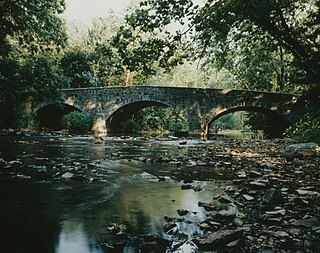
Bridge in Reed Township, originally known as Wiconisco Canal Aqueduct No. 3, is a historic multi-span stone arch bridge spanning Powell Creek on State Route 147 in Reed Township, Dauphin County, Pennsylvania. It was built in 1840, as an aqueduct. The property measures 72 feet (22 m) long by 50 feet (15 m) wide. It is built of red and white coursed ashlar and features a belt course and continuous parapet cap.

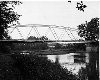
Bridge in Brown Township is a historic lattice truss bridge spanning Pine Creek at PA 414 in Brown Township, Lycoming County, Pennsylvania. It was built in 1890, by the Berlin Iron Bridge Co. of East Berlin, Connecticut. The bridge measures 227 feet (69 m) long and 19 feet (5.8 m) wide.

Bridge in Lewis Township was an historic Pratt through truss bridge spanning Lycoming Creek at Lewis Township, Lycoming County, Pennsylvania. It was built in 1890, and measures 171 feet long and 18 feet wide.
Bridge in Porter Township is a historic lenticular truss bridge spanning Pine Creek at Porter Township, Lycoming County, Pennsylvania. It was built in 1889, and is a single-span bridge that measures 287 feet (87 m) long and 20 feet (6.1 m) wide.

Bridge in Snake Spring Township, also known as the Narrows Bridge, is a historic concrete arch bridge located at The Narrows in Snake Spring Township in Bedford County, Pennsylvania. It was built in 1934, and is a 580-foot-long (180 m), open spandrel concrete arch bridge with five arches. The roadway is skewed and carries US 30, the Lincoln Highway, over the Raystown Branch Juniata River.

Bridge in Portage Township is a historic stone arch bridge located at Portage Township in Cambria County, Pennsylvania. It was built by the Allegheny Portage Railroad in 1832, and is an 18-foot-long (5.5 m) bridge, with a semi-circular arch. It is built of coursed ashlar and crosses Bens Creek.

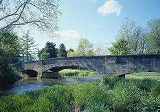
Maclay's Twin Bridge (East) is a historic multi-span stone arch bridge spanning a tributary of Conodoguinet Creek between Lurgan Township and Southampton Township in Franklin County, Pennsylvania. It is a 105-foot-long (32 m) bridge, with two spans each measuring 20 feet (6.1 m) long. It was constructed in 1827 and is a twin of McClay's Twin Bridge (West).
Maclay's Twin Bridge (West) is a historic multi-span stone arch bridge spanning a tributary of Conodoguinet Creek between Lurgan Township and Southampton Township in Franklin County, Pennsylvania. It is a 177-foot-long (54 m) bridge with three spans, the longest of which measures 31 feet (9.4 m) long. It was constructed in 1827 and is a twin of McClay's Twin Bridge (East).
Bridge in Metal Township, also known as Keggereis Ford Bridge, is a historic multi-span concrete arch bridge located at Metal Township in Franklin County, Pennsylvania. It is a 105-foot-long (32 m) bridge with three spans, the longest of which measures 45 feet (14 m) long. It was constructed in 1907. It carries Stone Bridge Road over the West Branch Conococheague Creek.
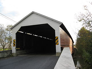
Pleasantville Bridge is a historic wooden covered bridge located at Oley Township in Berks County, Pennsylvania. It is a 126-foot-long (38 m), Burr Truss bridge, constructed between 1852 and 1856. It was built in two stages due to wood shortages after the Great Flood of 1850. It crosses the Manatawny Creek. It is one of five covered bridges remaining in Berks County.

The S Bridge was an historic, American stone arch bridge that was located in Marion Township in Berks County, Pennsylvania.

Campbell's Bridge formerly spanned Unami Creek on Allentown Road in Milford Square, Bucks County, Pennsylvania. The 72-foot-long (22 m), 20-foot-wide (6.1 m) bridge was built in 1906-1907. The bridge was designed by A. Oscar Martin and built by the Dailey Construction Company. It was one of the oldest examples of reinforced concrete arch bridges in the United States.

