Growth fault

Last updated
Fig. 1. Sketch showing a well-developed growth fault and accompanying structures. Fig 1 Emad final thin boundary1.jpg
Fig. 1. Sketch showing a well-developed growth fault and accompanying structures.

Growth faults are syndepositional or syn-sedimentary extensional faults that initiate and evolve at the margins of continental plates. [1] They extend parallel to passive margins that have high sediment supply. [2] Their fault plane dips mostly toward the basin and has long-term continuous displacement. Figure one shows a growth fault with a concave upward fault plane that has high updip angle and flattened at its base into zone of detachment or décollement. This angle is continuously changing from nearly vertical in the updip area to nearly horizontal in the downdip area.

Contents

Sedimentary layers have different geometry and thickness across the fault. The footwall – landward of the fault plane – has undisturbed sedimentary strata that dip gently toward the basin while the hanging wall – on the basin side of the fault plane – has folded and faulted sedimentary strata that dip landward close to the fault and basinward away from it. [3] These layers perch on a low density evaporite or over-pressured shale bed that easily flows away from higher pressure into lower pressure zones. [3] Most studies since the 1990s concentrate on the growth faults' driving forces, kinematics and accompanied structures since they are helpful in fossil fuel explorations as they form structural traps for oil.

Figure 2. Sketch showing evolution stages of three growth faults. The black arrow shows the direction of evolution. Fig 2 Emadfinal thin boundary2.jpg
Figure 2. Sketch showing evolution stages of three growth faults. The black arrow shows the direction of evolution.

Growth fault dynamics

Growth faults maturation is a long term process that takes millions of years with slip rate ranges between 0.2-1.2 millimeters per year. [4] [5] It starts when sedimentary sequences are deposited on top of each other above a thick evaporite layer (fig. 2). [6] A growth fault is initiated when the evaporite layer can no longer support the overlying sequences. The thicker and denser portion applies much more pressure on the evaporite layer than the thin portion. [6] As a result, a flow within the evaporite layer is initiated from high pressure areas toward low pressure areas causing growth ridges to form below the thin portion. Also, sinking zones are noticed among these ridges at areas where thicker and denser layers form(fig. 2).

Consequently, the passive margin experience unequal subsidence across the continental shelf. [7] Both the new-created accommodation spaces and the thickness of the new-deposited sedimentary layers are greater above the sinking zones than above the growth ridges. The new added layers are thicker within the footwall than within the hanging wall [7] (fig. 2). These variations result in an increasing of differential load intensities - unequal distribution of sediments load - across the shelf with time as more sediment layers are added(fig. 2). Therefore, the rate by which the pressure increases upon the evaporite layer below the sinking zone are much more than the rate of pressure increase upon the same evaporite layer at the growth ridges. So, the flow rate within the evaporite layer is progressively increasing as deferential load intensifies(fig. 2). The growth ridges end up with salt diapir when the sinking zone sequences weld to the base of the evaporite layer. [1]

As the fault grows upward, it cuts through the newly formed sedimentary layers at the top. Therefore, the overall displacement along the fault plane is not the same. [5] Further, the lowermost layer has higher displacement than the uppermost layer while the intermediate layer displacement lies in between (fig. 2). [1] Because the fault plane flattens into décollement, the downthrown block moves basinward and the displaced sedimentary layer of the downthrown block bends close to the fault plane forming rollover anticline, synthetic and antithetic faults. [7] Figure 3 is an E-W seismic line at Svalbard area showing footwall, hanging wall and the geometry of sedimentary layers around the fault plane. [8]

Fig. 3. Seismic line showing sedimentary layers, footwall and hanging wall of a growth fault: Modified after Bjerkvik, 2012 Modified after Bjerkvik, A. S. (2012). PhD.jpg
Fig. 3. Seismic line showing sedimentary layers, footwall and hanging wall of a growth fault: Modified after Bjerkvik, 2012

Accompanied structures

Growth faults have two blocks. The upthrown block – the footwall – is landward of the fault plane and the downthrown block – the hanging wall – is basinward of the fault plane. Most deformations occur within the hanging wall side. The downthrown block slips downward and basinward relative to the upthrown block. This is caused due to the differential load of the overlying sediments and the high mobility of the lowermost low density layer. [7]

As a result, the sedimentary layers collapse forming synthetic and antithetic dip-slip faults that dip in the same direction or in the opposite direction of the main growth fault respectively or bend forming rollover anticlines close to the fault plane. [7] Those structures are usually formed simultaneously and are thought to be created as a result of sediments filling the gap that is formed hypothetically by the basinward movement of the downthrown block. [9]

Driving force

The main driving forces of the growth faults are the deferential sediments load and the low density layers - evaporites or over-pressured shale - that are formed during or right after the rifting process. [10] Growth faults are located mainly within passive margin sedimentary wedges where tectonic forces have minimum or no effect. These passive margins receive millions of tons of sediments every year which are concentrated on the continental shelf below base level and above areas where the water velocity is no longer supporting the particles weight. [11] This zone is called depositional center (depocenter for short) and has higher sediments load.

Evaporites and/or high-pressured shale layers have the ability to flow because of their high mobility and low viscosity characteristics. Rift zones are partially restricted and have limited access to open oceans during rifting period. they are affected by sea level changes and climatic variability. [12] Thick layers of evaporites are formed due to continuous water evaporation and fill of the rift basin.

Shale beds that are deposited during the rift-drift stage have high porosity and low permeability. This encloses much fluid which under pressure causing the whole shale bed to turn into a viscous, low density, high mobility layer. The over-pressured shale layers trigger and initiate the growth faults in the same way as the evaporite layers does. [6]

Earthquakes arise and result from the release of the force along the growth fault plane. [12] The depocenter's exact location continuously changes because eustatic and relative sea level are continuously changing as well. As a result, many different growth faults are created as sediment loads shift basinward and landward. [10]

Importance of growth faults

Growth faults have great significance for stratigraphy, structural geology and the petroleum industry. They account for relative and eustatic sea level changes and accommodation space left for new sediments. [1] Likewise, growth faults are connected directly to the subsidence in the coastal and continental shelf areas. [3] [7] Moreover, they explain lateral thickness variation of sedimentary sequences across these faults. [1] The updip area on the downthrown block is the main target of oil and gas exploration because it has synthetic and antithetic faults and rollover anticlines. These are considered as structural traps preventing oil and gas from escaping. [1]

The offset of sand and shale beds occurring along fault planes bring sand and shale layers in contact to each other. This blocks oil and gas lateral movements and enhances vertical movements. [1] [9] At shallow depths, growth faults and their accompanying synthetic and antithetic faults are considered as vertical pathways for groundwater to flow and mix between different groundwater reservoirs. [9] At deeper areas, these conduits help geologists track petroleum migration up to their final destinations. [1] Oil and gas exploration is usually concentrated very close to these faults in the downthrown block because these are considered as structural traps preventing oil and gas from escaping.

Future work

Because the growth faults and their accompanied structures control both horizontal and vertical migration of the underground fluids, most of the current and future studies focus on constructing three-dimensional models in order to understand geometry and kinematics of these structures. This will unravel the mystery behind the groundwater contamination due to reservoir mixing, and track the oil and gas migration pathways.

Related Research Articles

Thrust fault Type of reverse fault that has a dip of 45 degrees or less

A thrust fault is a break in the Earth's crust, across which older rocks are pushed above younger rocks.

Sedimentary basin Regions of long-term subsidence creating space for infilling by sediments

Sedimentary basins are regions of the Earth where long-term subsidence creates accommodation space for accumulation of sediments. As the sediments are buried, they are subject to increasing pressure and begin the processes of compaction and lithification that transform them into sedimentary rock.

Permian Basin (North America) Large sedimentary basin in the US

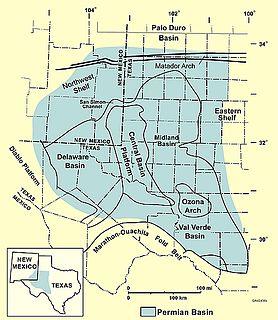
The Permian Basin is a large sedimentary basin in the southwestern part of the United States. The basin contains the Mid-Continent Oil Field province. This sedimentary basin is located in western Texas and southeastern New Mexico. It reaches from just south of Lubbock, past Midland and Odessa, south nearly to the Rio Grande River in southern West Central Texas, and extending westward into the southeastern part of New Mexico. It is so named because it has one of the world's thickest deposits of rocks from the Permian geologic period. The greater Permian Basin comprises several component basins; of these, the Midland Basin is the largest, Delaware Basin is the second largest, and Marfa Basin is the smallest. The Permian Basin covers more than 86,000 square miles (220,000 km2), and extends across an area approximately 250 miles (400 km) wide and 300 miles (480 km) long.

Niger Delta Basin (geology)

The Niger Delta Basin, also referred to as the Niger Delta province, is an extensional rift basin located in the Niger Delta and the Gulf of Guinea on the passive continental margin near the western coast of Nigeria with suspected or proven access to Cameroon, Equatorial Guinea and São Tomé and Príncipe. This basin is very complex, and it carries high economic value as it contains a very productive petroleum system. The Niger delta basin is one of the largest subaerial basins in Africa. It has a subaerial area of about 75,000 km2, a total area of 300,000 km2, and a sediment fill of 500,000 km3. The sediment fill has a depth between 9–12 km. It is composed of several different geologic formations that indicate how this basin could have formed, as well as the regional and large scale tectonics of the area. The Niger Delta Basin is an extensional basin surrounded by many other basins in the area that all formed from similar processes. The Niger Delta Basin lies in the south westernmost part of a larger tectonic structure, the Benue Trough. The other side of the basin is bounded by the Cameroon Volcanic Line and the transform passive continental margin.

Passive margin Transition between oceanic and continental lithosphere that is not an active plate margin

A passive margin is the transition between oceanic and continental lithosphere that is not an active plate margin. A passive margin forms by sedimentation above an ancient rift, now marked by transitional lithosphere. Continental rifting creates new ocean basins. Eventually the continental rift forms a mid-ocean ridge and the locus of extension moves away from the continent-ocean boundary. The transition between the continental and oceanic lithosphere that was originally created by rifting is known as a passive margin.

Foreland basin Structural basin that develops adjacent and parallel to a mountain belt

A foreland basin is a structural basin that develops adjacent and parallel to a mountain belt. Foreland basins form because the immense mass created by crustal thickening associated with the evolution of a mountain belt causes the lithosphere to bend, by a process known as lithospheric flexure. The width and depth of the foreland basin is determined by the flexural rigidity of the underlying lithosphere, and the characteristics of the mountain belt. The foreland basin receives sediment that is eroded off the adjacent mountain belt, filling with thick sedimentary successions that thin away from the mountain belt. Foreland basins represent an endmember basin type, the other being rift basins. Space for sediments is provided by loading and downflexure to form foreland basins, in contrast to rift basins, where accommodation space is generated by lithospheric extension.

In sedimentology, compaction is the process by which a sediment progressively loses its porosity due to the effects of pressure from loading. This forms part of the process of lithification. When a layer of sediment is originally deposited, it contains an open framework of particles with the pore space being usually filled with water. As more sediment is deposited above the layer, the effect of the increased loading is to increase the particle-to-particle stresses resulting in porosity reduction primarily through a more efficient packing of the particles and to a lesser extent through elastic compression and pressure solution. The initial porosity of a sediment depends on its lithology. Mudstones start with porosities of >60%, sandstones typically ~40% and carbonates sometimes as high as 70%. Results from hydrocarbon exploration wells show clear porosity reduction trends with depth. Compaction trend estimation and decompaction process are useful for analyzing numerical basin evolution and evaluating hydrocarbon reservoirs and geological storages.

Tectonic subsidence is the sinking of the Earth's crust on a large scale, relative to crustal-scale features or the geoid. The movement of crustal plates and accommodation spaces created by faulting create subsidence on a large scale in a variety of environments, including passive margins, aulacogens, fore-arc basins, foreland basins, intercontinental basins and pull-apart basins. Three mechanisms are common in the tectonic environments in which subsidence occurs: extension, cooling and loading.

The salt tectonics off the Louisiana gulf coast can be explained through two possible methods. The first method attributes spreading of the salt because of sedimentary loading while the second method points to slope instability as the primary cause of gliding of the salt. The first method results in the formation of growth faults in the overlying sediment. Growth faults are normal faults that occur simultaneously with sedimentation, causing them to have thicker sediment layers on the downthrown sides of the faults. In the second method both the salt and the sediment are moving, making it more likely to migrate.

Half-graben Geological structure bounded by a fault along one side of its boundaries

A half-graben is a geological structure bounded by a fault along one side of its boundaries, unlike a full graben where a depressed block of land is bordered by parallel faults.

Salt surface structures

Salt surface structures are extensions of salt tectonics that form at the Earth's surface when either diapirs or salt sheets pierce through the overlying strata. They can occur in any location where there are salt deposits, namely in cratonic basins, synrift basins, passive margins and collisional margins. These are environments where mass quantities of water collect and then evaporate; leaving behind salt and other evaporites to form sedimentary beds. When there is a difference in pressure, such as additional sediment in a particular area, the salt beds – due to the unique ability of salt to behave as a fluid under pressure – form into new structures. Sometimes, these new bodies form subhorizontal or moderately dipping structures over a younger stratigraphic unit, which are called allochthonous salt bodies or salt surface structures.

Northern North Sea basin

The North Sea is part of the Atlantic Ocean in northern Europe. It is located between Norway and Denmark in the east, Scotland and England in the west, Germany, the Netherlands, Belgium and France in the south.

Persian Gulf Basin

The Persian Gulf Basin, is found between the Eurasian and the Arabian Plate. The Persian Gulf is described as a shallow marginal sea of the Indian Ocean that is located between the south western side of Iran and the Arabian Peninsula and south and southeastern side of Oman and the United Arab Emirates. Other countries that border the Persian Gulf basin include; Saudi Arabia, Qatar, Kuwait, Bahrain and Iraq. The Persian Gulf extends a distance of 1,000 km (620 mi) with an area of 240,000 km2 (93,000 sq mi). The Persian Gulf basin is a wedge-shaped foreland basin which lies beneath the western Zagros thrust and was created as a result of the collision between the Arabian and Eurasian plates.

Columbus Basin

The Columbus Basin is a foreland basin located off the south eastern coast of Trinidad within the East Venezuela Basin (EVB). Due to the intensive deformation occurring along the Caribbean and South American plates in this region, the basin has a unique structural and stratigraphic relationship. The Columbus Basin has been a prime area for hydrocarbon exploration and production as its structures, sediments and burial history provide ideal conditions for generation and storage of hydrocarbon reserves. The Columbus Basin serves as a depocenter for the Orinoco River delta, where it is infilled with 15 km of fluvio-deltaic sediment. The area has also been extensively deformed by series of north west to southeast normal faults and northeast to southwest trending anticline structures.

Taranaki Basin

The Taranaki Basin is an onshore-offshore Cretaceous rift basin on the West Coast of New Zealand. Development of rifting was the result of extensional stresses during the breakup of Gondwanaland. The basin later underwent fore-arc and intra-arc basin development, due to the subduction of the Pacific Plate under the Australian Plate at the Hikurangi Subduction System. The basin covers approximately 100,000 km2 of which the majority is offshore. The basin contains mostly marine sediment, with significant terrestrial sediment from the Late Cretaceous to the Eocene. The majority of New Zealand's oil and gas production occurs within the basin, with over 400 wells and approximately 20 oil and gas fields being drilled.

The Angola Basin is located along the West African South Atlantic Margin which extends from Cameroon to Angola. It is characterized as a passive margin that began spreading in the south and then continued upwards throughout the basin. This basin formed during the initial breakup of the supercontinent Pangaea during the early Cretaceous, creating the Atlantic Ocean and causing the formation of the Angola, Cape, and Argentine basins. It is often separated into two units: the Lower Congo Basin, which lies in the northern region and the Kwanza Basin which is in the southern part of the Angola margin. The Angola Basin is famous for its "Aptian Salt Basins," a thick layer of evaporites that has influenced topography of the basin since its deposition and acts as an important petroleum reservoir.

Delta Field (Niger Delta)

The Delta Field is located offshore from Nigeria on Oil Mining Leases (OML) 49 and 95. This is located within the Niger Delta Basin and sits in 12 feet of water. In 1965, the Delta 1 well was completed and the Delta Field opened in 1968 for production.

Nam Con Son Basin

The Nam Con Son Basin formed as a rift basin during the Oligocene period. This basin is the southernmost sedimentary basin offshore of Vietnam, located within coordinates of 6°6'-9°45'N and 106°0-109°30'E in the East Vietnam Sea. It is the largest oil and gas bearing basin in Vietnam and has a number of producing fields.

Junggar Basin

The Junggar Basin is one of the largest sedimentary basins in Northwest China. It is located in Xinjiang, and enclosed by the Tarbagatai Mountains of Kazakhstan in the northwest, the Altai Mountains of Mongolia in the northeast, and the Heavenly Mountains in the south. The geology of Junggar Basin mainly consists of sedimentary rocks underlain by igneous and metamorphic basement rocks. The basement of the basin was largely formed during the development of the Pangea supercontinent during complex tectonic events from Precambrian to late Paleozoic time. The basin developed as a series of foreland basins – in other words, basins developing immediately in front of growing mountain ranges – from Permian time to the Quaternary period. The basin's preserved sedimentary records show that the climate during the Mesozoic era was marked by a transition from humid to arid conditions as monsoonal climatic effects waned. The Junggar basin is rich in geological resources due to effects of volcanism and sedimentary deposition.

The Officer Basin is an intracratonic sedimentary basin that covers roughly 320,000 km2 along the border between southern and western Australia. Exploration for hydrocarbons in this basin has been sparse, but the geology has been examined for its potential as a hydrocarbon reservoir. This basin's extensive depositional history, with sedimentary thicknesses exceeding 6 km and spanning roughly 350 Ma during the Neoproterozoic, make it an ideal candidate for hydrocarbon production.

References

  1. 1 2 3 4 5 6 7 8 Cazes, C. A. (2004). "Overlap Zones, Growth Faults, and Sedimentation: Using High Resolution Gravity Data, Livingston Parish, LA.". Faculty of the Louisiana State University and Agricultural and Mechanical College in partial fulfillment of the requirements for the degree of Master of Science in The Department of Geology and Geophysics; Louisiana State University, Thesis": 147.{{cite journal}}: Cite journal requires |journal= (help)
  2. Schlische, R.W.; Anders, M.H. (1996). "Stratigraphic effects and tectonic implications of the growth of normal faults and extensional basins. In: Berata, K. (Ed.), Reconstructing the History of the Basin and Range Extension using Sedimentology and Stratigraphy". Geological Society of America. 303: 183–203. doi:10.1130/0-8137-2303-5.183.
  3. 1 2 3 Doglioni, C.; D’Agostino, N.; Mariotti, G. (1998). "Normal faulting versus regional subsidence and sedimentation rate". Marine and Petroleum Geology . 15: 737–750. doi:10.1016/s0264-8172(98)00052-x.
  4. Gagliano, S.M.; Kemp, E.B.; Wicker, K.M.; Wiltenmuth, K.S. (2003). "Active geological faults and land change in southeastern Louisiana". Prepared for U.S. Army Corps of Engineers, New Orleans District,. Contract No. DACW 29-00-C-0034.
  5. 1 2 Yeager, K. M.; Brunner C. A.; Kulp, M. A.; Fischer, D.; Feagin, R. A.; Schindler K. J.; Prouhet, J.; Bera, G. (2012). "Significance of active growth faulting on marsh accretion processes in the lower Pearl River, Louisiana". Geomorphology. 153–154: 127–143. doi:10.1016/j.geomorph.2012.02.018.
  6. 1 2 3 Yuill, B.; Lavoie, D.; Reed, D.J. (2009). "Understanding subsidence processes in coastal Louisiana". Journal of Coastal Research. 10054: 23–36. doi:10.2112/si54-012.1.
  7. 1 2 3 4 5 6 Kuecher, G.J; Roberts H. H; Thompson, M. D.; Matthews, I. (2001). "Evidence for active growth faulting in the Terrebone delta plain, south Louisiana: implications for wetland loss and the vertical migration of petroleum". Environmental Geosciences. 2 (8): 77–94.
  8. Bjerkvik, A. S. (2012). "Seimic analysis of Carboniferous rift basin and Triassic growth-fault basins of Svalbard; analysis of seismic facies patterns with bearing on basin geometry and growth-strata successions (Doctoral dissertation, Norwegian University of Science and Technology". Earth Sciences and Petroleum Engineering.
  9. 1 2 3 Losh, S.; Eglinton, L.; Schoell, M.; Wood, J. (1999). "Vertical and lateral fluid flow related to a large growth fault, South Eugene Island Block 330 Field, offshore Louisiana". American Association of Petroleum Geologists. 83 (2): 244–276.
  10. 1 2 Verge´s, J.; Marzo, M.; Muñoz, J. A. (2002). "Growth strata in foreland settings". Sedimentary Geology. 146: 1–9. doi:10.1016/s0037-0738(01)00162-2.
  11. Gawthorpe, R.L.; Fraser, A.J.; Collier, R.E.L. (1994). "Sequence stratigraphy in extensional basins: implications for the interpretation of ancient basin-fills". Marine and Petroleum Geology. 11: 642–658. doi:10.1016/0264-8172(94)90021-3.
  12. 1 2 Gawthorpe, R. L.; Leeder, M.R. (2000). "Tectono-sedimentary evolution of active extensional basins". Basin Research. 12: 195–218. doi:10.1111/j.1365-2117.2000.00121.x.