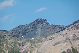
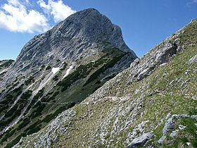
Große Arnspitze | |
---|---|
Große Arnspitze | |
Highest point | |
Elevation | 2,196 m (AA) (7,205 ft) |
Prominence | 1,003 m ↓ Northwest of Neuleutasch → Reither Spitze |
Isolation | 3.9 km → Upper Wettersteinspitze |
Coordinates | 47°23′50″N11°13′21″E / 47.3971306°N 11.2225417°E Coordinates: 47°23′50″N11°13′21″E / 47.3971306°N 11.2225417°E |
Geography | |
Parent range | Wettersteingebirge, Northern Limestone Alps |
Geology | |
Age of rock | Triassic |
Mountain type | Wetterstein Limestone [1] |
Climbing | |
Easiest route | Scharnitz – Arnspitzhütte – Große Arnspitze |
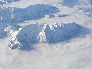
The Große Arnspitze is the highest peak in the Arnspitze Group in the Wettersteingebirge mountains. It is located west of Scharnitz in Austria. The border between Germany and Austria runs over its summit.
The Arnspitze Group is a free-standing mountain chain in Austrian and Germany, in the states of Tyrol and Bavaria, between Seefeld in Tirol and Mittenwald, and between the Leutasch valley in the west and the Isar valley near Scharnitz in the east. In the literature, the Arnspitze Group is classed as part of the Wettersteingebirge. The majority of the group belongs to Tyrol, a northeastern part of the chain lies in Bavaria. The border between Bavaria and Tyrol runs over the summit of the Große Arnspitze.
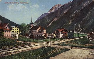
Scharnitz is a municipality in the district of Innsbruck-Land in the Austrian state of Tyrol located 16.4 kilometres (10.2 mi) north of Innsbruck and 9 kilometres (5.6 mi) from Seefeld in Tirol on the German border. It is one of the largest municipalities and has 10 parts: Au, Eisack, Gießenbach, Inrain, Jägerviertel, Oberdorf, Schanz, Schießstand, Siedlung, Unterdorf. The village was founded in the early Middle Ages and was once an important commercial route between Germany and Italy. The main source of income is tourism, both in summer and winter. Scharnitz is the western entry point to the Hinterau valley, where the source of river Isar is located.
Germany, officially the Federal Republic of Germany, is a country in Central and Western Europe, lying between the Baltic and North Seas to the north, and the Alps to the south. It borders Denmark to the north, Poland and the Czech Republic to the east, Austria and Switzerland to the south, France to the southwest, and Luxembourg, Belgium and the Netherlands to the west.
The normal climbing route, Weg 851, runs from Scharnitz westwards and below the Ahrntalköpfle to the Riedberg. Below this mountain the path bends to the southwest from the Arnspitzhütte, whence it heads northwest to the summit.
Seefeld in Tirol is an old farming village, now a major tourist resort, in Innsbruck-Land District in the Austrian state of Tyrol with a local population of 3,312. The village is located about 17 km (11 mi) northwest of Innsbruck on a plateau between the Wetterstein mountains and the Karwendel on a historic road from Mittenwald to Innsbruck that has been important since the Middle Ages. It was first mentioned in 1022 and since the 14th century has been a pilgrimage site, benefiting not only from the visit of numerous pilgrims but also from its stacking rights as a trading station between Augsburg and the Venice. Also since the 14th century, Tyrolean shale oil has been extracted in the area. Seefeld was a popular holiday resort even before 1900 and, since the 1930s, has been a well known winter sports centres and amongst the most popular tourist resorts in Austria. The municipality, which has been the venue for several Winter Olympics Games, is the home village of Anton Seelos, the inventor of the parallel turn.
The Krottenkopf, 2,086 metres/6,844 ft, is a peak in the Ester Mountains and the highest mountain in the Bavarian Prealps. It lies within the Bavarian district of Garmisch-Partenkirchen.
Leutasch is a municipality in the northern part of the district Innsbruck-Land in the Austrian state of Tyrol about 30 km northwest of Innsbruck and 10 km northwest of Seefeld in Tirol
The Wetterstein mountains, colloquially called Wetterstein, is a mountain group in the Northern Limestone Alps within the Eastern Alps. It is a comparatively compact range located between Garmisch-Partenkirchen, Mittenwald, Seefeld in Tirol and Ehrwald along the border between Germany (Bavaria) and Austria (Tyrol). Zugspitze, the highest peak is at the same time the highest mountain in Germany.
The Ellmauer Halt (2,344 m) is the highest peak in the mountain massif of the Wilder Kaiser in the Kaiser range in the Austrian state of Tyrol. To the east is the summit of the Kapuzenturm, a striking and isolated rock pinnacle. In 1883 the first summit cross was erected on the mountain top.
The Pyramidenspitze is a mountain, 1,998 metres high, of the Kaisergebirge in the Austrian state of Tyrol.
The Hocheisspitze is a 2,523 m high mountain in the Berchtesgaden Alps, over which the border between Germany and Austria runs. It is also the highest mountain in the eponymous Hocheis Group that belongs to the Hochkalter Massif.
The Pinzgau Ridgeway is a roughly 25 kilometre long ridgeway in the Kitzbühel Alps in the Austrian federal state of Salzburg.
The Lizumer Reckner is, at 2,886 m above sea level (AA), the highest mountain in the Tux Alps in the Austrian state of Tyrol.
The Hafelekarspitze is a mountain in the so-called North Chain (Nordkette) north of Innsbruck in Austria.
The Scharnitz Pass is a narrow section of the upper Isar valley in the Northern Limestone Alps. It lies at a height of about 955 m on the Austro-German border between the states of Bavaria and Tyrol. Its name derives from the village of Scharnitz immediately to the south.
The Zirler Berg near Zirl in the Austrian federal state of Tyrol is a mountain, 1,057 m (AA) high, in the Karwendel Alps, a western part of the Northern Limestone Alps. It is a southern foothill of the Reither Spitze and is known mainly because the Seefelder Straße (B 177) on its southern slopes climbs through 388 metres in a distance of less than 4 kilometres from Zirl in the Inn valley to Leithen on the Seefeld Plateau.
The Hochplattig is a mountain, 2,768 m (AA) high, and the highest summit in the Mieming Chain, a mountain range in the Northern Limestone Alps in the Austrian state of Tyrol.
The Daniel is a mountain in the Austrian state of Tyrol, and the highest peak in the Ammergau Alps, a range within the Northern Limestone Alps . Located near the villages of Ehrwald and Lermoos, it is a popular mountain with hikers. Its North Face is around 200 metres high and its South Face has a more schrofen-like character. With the almost equally high Upsspitze it forms a double summit. To the northwest is a neighbouring peak, the Hochschrutte.
The Kohlbergspitze is a 2,202 m (AA) high summit on the main chain of the Ammergau Alps in Tyrol, Austria. Less common names for the mountain are the Zigersteinjoch, Stapferwiesjoch and Zigerstein. With its 300-metre-high north faces and grassy and less steep southern slopes is the first prominent summit in the western part of the main chain.
A double summit, double peak, twin summit or twin peak refers to a mountain or hill that has two summits, separated by a col or saddle.
At 2,163 metres, the Gehrenspitze is the third highest mountain in the Tannheim Group and is situated in the Austrian state of Tyrol. It should not be confused with the Gehrenspitze in the Wetterstein Mountains.
Kompass Karten is an Austrian map publisher based in Innsbruck, which specialises in hiking maps, and guides, digital maps, and cycling maps and guides. Its range has over 1,000 titles.
The International Standard Book Number (ISBN) is a numeric commercial book identifier which is intended to be unique. Publishers purchase ISBNs from an affiliate of the International ISBN Agency.
This Bavaria location article is a stub. You can help Wikipedia by expanding it. |