Bulawayo is the second largest city in Zimbabwe, and the largest city in the country's Matabeleland region. The city's population is disputed; the 2022 census listed it at 665,940, while the Bulawayo City Council claimed it to be about 1.2 million. Bulawayo covers an area of 546 square kilometres in the western part of the country, along the Matsheumhlope River. Along with the capital Harare, Bulawayo is one of two cities in Zimbabwe that are also provinces.

Matabeleland North is a province in western Zimbabwe. With a population of 827,645 as of the 2022 census, it is the country's second-least populous province, after Matabeleland South, and the least densely Zimbabwean populated province. Matabeleland North and Matabeleland South were established in 1974, when the original Matabeleland Province was bifurcated, eventually losing territory in 1997 when the city of Bulawayo became a province in its own right. Matabeleland North is divided into seven districts, has its capital in Lupane, and Victoria Falls and Hwange its largest towns. The name "Matabeleland" is derived from the Matabele or Ndebele people, the province's largest ethnic group.

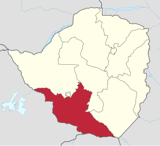
Matabeleland South is a province in southwestern Zimbabwe. With a population of 683,893 as of the 2012 Zimbabwean census. It is the country's least populated province after Matabeleland North.Matabeleland South and Matabeleland North were established in 1974, when the original Matabeleland Province was bifurcated. The province is divided into six districts. Gwanda is the capital, and Beitbridge is the province's largest town. The name "Matabeleland" is derived from Ndebele, the province's largest ethnic group.

Provinces are constituent political entities of Zimbabwe. Zimbabwe currently has ten provinces, two of which are cities with provincial status. Zimbabwe is a unitary state, and its provinces exercise only the powers that the central government chooses to delegate. Provinces are divided into districts, which are divided into wards.

Beitbridge is a border town in the province of Matabeleland South, Zimbabwe. The name also refers to the border post and bridge spanning the Limpopo River, which forms the political border between South Africa and Zimbabwe. The border on the South African side of the river is also named Beitbridge.
Esigodini, originally known as Essexvale, is a town in the Matabeleland South Province of Zimbabwe. It is the administrative centre for Umzingwane District, one of the seven administrative districts in Matabeleland South. It was originally an estate of Frederick Selous, a British explorer, officer, professional hunter, and conservationist.

Marist Brothers Secondary School, Dete (MBSS), otherwise referred to as 'Marist Dete' is a co-educational (mixed) boarding secondary school Dete, in the Hwange district of Zimbabwe’s Matabeleland North Province. The school was established in 1972 and is part of the international family of Marist schools run by the Marist Brothers, a Catholic society founded in 1817 by Saint Marcellin Champagnat in France.

Lupane ( luːpɑːnɛ) District is located in the Matabeleland North Province of Zimbabwe, and it is also the Provincial Capital. The District is situated at an elevation of 976 m with a population of 107,000 inhabitants by 2022. Lupane Town is the main center of the district located 172 km from Bulawayo along the A8 Victoria Falls Road. The Government Provincial Administrative offices are located at the Town Centre. A new university near the Town has been established under the name Lupane State University, which caters for the region and beyond. The word Lupane is thought to be a Kalanga or Lozwi word.
Mtshabezi Mission is a village in Gwanda District of Matabeleland South province in southern Zimbabwe.
Gungwe(Gongwe) is a village in Gwanda District of Matabeleland South province in southern Zimbabwe.
Lushongwe is a village in Gwanda District of Matabeleland South province in southern Zimbabwe.

Manama is a village in Gwanda District ward, in the province of Matabeleland South, Zimbabwe. It is located south of Gwanda on the road to Kafusi.
Matshetshe is a village in Gwanda District of Matabeleland South province in southern Zimbabwe.
Mzimuni is a village in Gwanda District of Matabeleland South province in southern Zimbabwe.

Ntalale is a village in Gwanda District of Matabeleland South province in southern Zimbabwe.

Silonga is a village in Gwanda District of Matabeleland South province in southern Zimbabwe.
Simbumbumbu is a village in Gwanda District, Matabeleland South Province, in southern Zimbabwe.

Umzingwane is a district in the northern part of Matabeleland South province in Zimbabwe. It was formerly known as Esigodini and before 1982 as Essexvale.

Mangwe District is a district of the Province Matabeleland South in Zimbabwe. It is divided into 17 wards. Some of the wards are Ngwizi, Mphoengs, Sanzukwi, Sangulube, Maninji, Madabe, Mbakwe, Empandeni, Mayobodo, Mambale, Makorokoro, Tshitshi, and Marula. Some villages found in this district are Bulu, Kweneng, Togotsweu. Mangwe used to be a part of bigger district which was known as Bulilimamangwe. Bulilimamangwe was then divided into 3 districts now known as Mangwe, Bulilima and Plumtree.
Dauti Salatiel Mabusa was a Zimbabwean activist and politician, who was born in Gwaranyemba in Gwanda District.


