
Rayagada district is a district in southern Odisha, a state in India, which became a separate district in October 1992. Its population consists mainly of tribes, primarily the Khonds and the Soras. In addition to Odia, Kui and Sora are spoken by the district's indigenous population. It was founded by Maharajah Biswanatha Deba Gajapati of the Surjyabansha dynasty of Jeypore.

Koraput district is a district of India in southern Odisha, with headquarters at Koraput. The district is located in the Eastern Ghats and is known for its hilly terrain, rich and diverse types of mineral deposits and its tribal culture and traditions. The district headquarters town of Koraput and its largest city, Jeypore are major centres of trade and commerce for South Odisha and fall on an important road connecting Visakhapatnam to Raipur.

Gajapati district is a district of Odisha State in India. It was created from Ganjam District on 2 October, 1992. Gajapati district was named after Krushna Chandra Gajapati Narayan Deb, the King of the Paralakhemundi estate and the first Prime Minister of Orissa, who is remembered for his contribution in the formation of a separate state, and inclusion of his estate in Odisha. The district headquarters at Paralakhemundi, formerly a Zamindari, has been clustered within a radius of approximately 5 kilometers around the geometric centre of Paralakhemundi. The District is a part of the Red Corridor. As of 2011 it is the third least populous district of Odisha, after Debagarh and Boudh.

Vizianagaram district is one of the six districts in the Uttarandhra region of the Indian state of Andhra Pradesh with its headquarters located at Vizianagaram. The district was once the part of ancient Kalinga.Saripilli Dibbilingeswara temple, Jayathi Mallikarjuna Temple are the finest examples of ancient Eastern Ganga Dynasty built monuments in the district. The district is bounded on the east by the district of Srikakulam, north by Parvathipuram Manyam south by Visakhapatnam, Anakapalli, southeast by the Bay of Bengal, and west by Alluri Sitharama Raju district. It was formed on 1 June 1979, with some parts carved from the neighbouring districts of Srikakulam and Visakhapatnam. The district is named after the princely state of Vizianagaram. In 2011, it was the least populous district in Andhra Pradesh.

Anakapalli is a residential neighborhood in the city of Visakhapatnam, also the headquarters of Anakapalli district of Andhra Pradesh. In 2015 Anakapalli municipality was merged with the Greater Visakhapatnam Municipal Corporation. It falls under zone 7 of GVMC. India's second largest jaggery market is located over here.

Gunupur is a Municipality and one of the sub-divisional headquarters of Rayagada district in the Indian state of Odisha. It is the second biggest town in Rayagada district.

The River Nagavali also known as Langulya is one of the main rivers of Southern Odisha and North Andhra States in India, between Rushikulya and Godavari basins.

Srungavarapukota popularly known by its abbreviated form S.Kota is a neighbourhood in the district of Vizianagaram, India. S.Kota is located on Visakhapatnam – Araku road. The town was upgraded from gram panchayat to Nagar Panchayat in the year 2011.
Gudari is a town and a Notified Area Council (N.A.C.) in Rayagada district in the Indian state of Odisha. Gudari got the Status of N.A.C in 1972 and recently completed 50 years.It is the 3rd biggest town in Rayagada District followed by Rayagada and Gunupur in 1st and 2nd .As of Latest India census,[3] Gudari has a population of 16,708

Palakonda is a town in Parvathipuram Manyam district of the Indian state of Andhra Pradesh. It is a nagar panchayat and the mandal headquarters of Palakonda mandal in Palakonda revenue division

Pathapatnam is a town in Srikakulam district of the Indian state of Andhra Pradesh. It is located in Pathapatnam mandal of Palakonda revenue division. Pathapatnam is located on the border of Srikakulam district of Andhra Pradesh and Gajapati district of Odisha. Parlakhemundi, the headquarters of Gajapati District, can be considered as twin town of Pathapatnam because of its close proximity. It is located around 65 km from srikakulam. It was the old capital of Paralakhemundi Gajapati Maharajah of his erstwhile kingdom.
Sarubujjili is a village in Srikakulam district of the Indian state of Andhra Pradesh. Sarubujjili mandal is bordered by Burja, Seethampeta, Hiramandalam, Jalumuru and Narasannapeta mandals of Srikakulam district.
Naupada is a village located in Santha Bommali mandal of Srikakulam district near to major town palasa, Andhra Pradesh, India. It is famous for salt fields and called the "Salt Bowl of Andhra Pradesh". It is better known for its railway junction station.
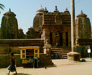
Mukhalingam, also known as Srimukhalingam or Mukhalinga, is a village panchayat in Jalumuru mandal of Srikakulam district in the Indian state of Andhra Pradesh. Historically known as Kalinganagari, Mukhalingam served as the capital of Eastern Ganga Dynasty from 6th century AD to 12th century AD. Emperor Sri Ananthavarma Chodaganga Devara conquered Utkala(Odisha) in 1122 AD and shifted the capital from Kalinganagari to Caudwara kataka
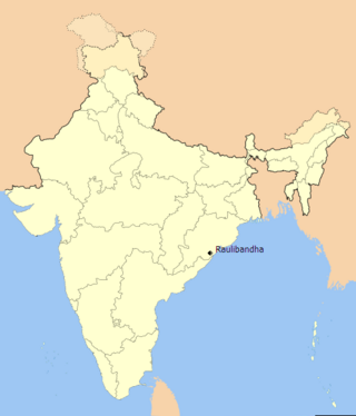
Raulibandha is a village in Malada Gram Panchayat, Ganjam district in the state of Odisha, India.
Badagam is a small village in the Rayagada Block and Parlakhemundi municipality in Gajapati district in the Indian state of Odisha. The major languages spoken in this place are Kui and Oriya.
Padmapur is a village in the Rayagada district of Odisha, India. It is the most populated village and one of the identified tourist centers of the district. A hillock adjoins the village to its northern side to enhance the scenic beauty of the place. A 7th century inscription found here, in the Nilakantheswar Temple, indicates that the Jagamanda hill, located close by, once housed the monastery of the famous Buddhist logician-philosopher Dharmakirti.

Durgi is a census village & Panchayat Headquarter of Bissam Cuttack Block in Rayagada district of Odisha, India. There are total 439 families residing in this village. The wards/ villages comes under Durgi Panchayat are:- Durgi, Bhaleri, Kundanpadar, Rengabai, Barangpadar, Thambalpadhu, Budhanagar, Kachapai, Kalipadar, Kurankul, Tentili Kalipadar, Mulipada, Dharamguda, Balipadar, Haduguda, Huruguda, Khariguda and IAY Colony.
Sirijholi, also spelled Sirijholly), is a medium-sized village located in the Indian state of Odisha in the Rayagada district. It is the panchayat headquarter of the Sirijholi Grama Panchayat and is administrated by a Sarapancha.
Barabatia is a village in Bhadrak district, Odisha. It is comes under the Tihidi block and governed locally under the panchayata raj system with the panchayat headed by a sarpanch. The village comes under the Harisinghpur Panchayat. Being a rural area the traditional culture, festival and heritage have flourished here.
haddubangi is the panchayat head quaqrter of the hadubhangi Gp the surrounding villages are vistala, chudangapur, parusarampurand konduru.chudangapur upgraded high school is the only high school in the panchayat