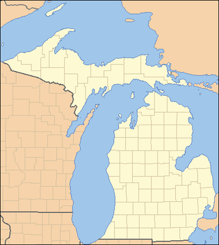
This is a list of properties on the National Register of Historic Places in the U.S. state of Michigan.
This National Park Service list is complete through NPS recent listings posted June 23, 2023.
Tulin is a village and a gram panchayat in the Jhalda I CD block in the Jhalda subdivision of the Purulia district in the state of West Bengal, situated beside the Subarnarekha River.

Pushpagiri was an ancient Indian mahavihara or monastic complex located atop Langudi Hill in Jajpur district of Odisha, India. Pushpagiri was mentioned in the writings of the Chinese traveller Xuanzang and some other ancient sources. Until the 1990s, it was hypothesised to be one or all of the Lalitgiri-Ratnagiri-Udayagiri group of monastic sites, also located in Jajpur district. These sites contain ruins of many buildings, stupas of various sizes, sculptures, and other artifacts.
Sundarpur is a village in Tangi Block of Khordha district, Orissa, India.

Udayagiri is the largest Buddhist complex in the Indian state of Odisha. It is composed of major stupas and monasteries (viharas). Together with the nearby complexes of Lalitgiri and Ratnagiri, it is part of the "Diamond Triangle" of the "Ratnagiri-Udayagiri-Lalitgiri" complex. It used to be thought that one or all of these were the Pushpagiri Vihara known from ancient records, but this has now been convincingly located at a different site. Per epigraphical artifacts found at the site, Udayagiri's historical name was "Madhavapura Mahavihara." This Buddhist complex, preceded by the Ratnagiri and Lalitgiri sites, with their monasteries, is believed to have been active between the 7th and the 12th centuries.
Maharashtra Udayagiri Institute of Management and Technology Somnathpur is an engineering college based in Udgir, India. It was founded in 2009 and is a part of the Maharashtra Udaygiri Education Society's group of educational institutions.

Girdharpur is a village in Bareilly district of the Indian state of Uttar Pradesh. It is 3 kilometers away from State Highway 37 and lies within the coordinates 28°42'51.60"N & 79°27'46"E.
Maurbojh is a village in the Mau District in the Indian state of Uttar Pradesh.
Vyaspur is a village in Chiraigaon block of Varanasi district in the Indian state of Uttar Pradesh. It is about 219 kilometers from the state capital Lucknow and 809 kilometers from the national capital Delhi.
Araji Line is a village in Varanasi district in the Indian state of Uttar Pradesh. It is about 275 kilometers from the state capital Lucknow and 798 kilometers from the national capital Delhi.
Azoarepur is a village in Pindra Tehsil of Varanasi district in the Indian state of Uttar Pradesh. The village falls under the Sarvipur gram panchayat. The village is about 39 kilometres northwest of Varanasi city, 284 kilometres southeast of the state capital Lucknow, and 789 kilometres southeast of the national capital Delhi.
Babatpur is a village, near Varanasi city in Pindra Tehsil of Varanasi district in the Indian state of Uttar Pradesh. The village falls under gram panchayat by the same name as the village. The village also houses Lal Bahadur Shastri Airport which serves Varanasi district. The village is about 26 kilometers North-West of Varanasi city, 260 kilometers South-East of state capital Lucknow and 797 kilometers South-East of the national capital New Delhi.
Bachaura is a village in Pindra Tehsil of Varanasi district in the Indian state of Uttar Pradesh. The village falls under gram panchayat by the same name as the village. The village is about 34 kilometers North-West of Varanasi city, 273 kilometers South-East of state capital Lucknow and 794 kilometers South-East of the national capital Delhi.
Baghaita is a village in Pindra Tehsil of Varanasi district in the Indian state of Uttar Pradesh. The village falls under Nihalapur gram panchayat. The village is about 20 kilometers North-West of Varanasi city, 266 kilometers South-East of state capital Lucknow and 804 kilometers South-East of the national capital Delhi.
Baharipur is a village in Pindra Tehsil of Varanasi district in the Indian state of Uttar Pradesh. The village falls under the Aharak gram panchayat. The village is about 20 kilometers North-West of Varanasi city, 291 kilometers South-East of state capital Lucknow and 805 kilometers South-East of the national capital Delhi.
Kaluneerkulam is a village panchayat located in the Tirunelveli district of Tamil Nadu, India.
Israna is a village panchayat and tehsil in Panipat district in Haryana, India. It lies in the panipat Division. It is located 18 kilometres (11 mi) towards south from district headquarters Panipat and 188 kilometres (117 mi) from state capital Chandigarh towards north.
Pamenahalli is a village in Harihara Taluk in Davangere District of Karnataka State, India. It comes under Sarathi Panchayath. It belongs to Bangalore Division. It is located 17 km towards west from District headquarters Davanagere. 298 km from State capital Bangalore.
Manikhira is a village near Thakurnagar in Gaighata CD Block in Bangaon subdivision of the North Twenty Four Parganas district in the West Bengal state of India.
Nuagada is a village and Community Development Block in the Gajapati District of Odisha state in India. The Block comes under the administrative control of Serango and R.Udayagiri Police station. The Block had a population of 57,027 in 2020 census. Mohana is its Vidhan Sabha constituency. This constituency includes Mohana block, R.Udayagiri block, Nuagada block and Rayagada block.


