Related Research Articles

Franconia is a region of Germany, characterised by its culture and East Franconian dialect . Franconia is made up of the three Regierungsbezirke of Lower, Middle and Upper Franconia in Bavaria, the adjacent, Franconian-speaking, South Thuringia, south of the Thuringian Forest—which constitutes the language boundary between Franconian and Thuringian—and the eastern parts of Heilbronn-Franconia in Baden-Württemberg.

The geography of Switzerland features a mountainous and landlocked country located in Western and Central Europe. Switzerland's natural landscape is marked by its numerous lakes and mountains. It is surrounded by five countries: Austria and Liechtenstein to the east, France to the west, Italy to the south and Germany to the north. Switzerland has a maximum north–south length of 220 kilometres (140 mi) and an east–west length of about 350 kilometres (220 mi).

Upper Franconia is a Regierungsbezirk of the state of Bavaria, southern Germany. It forms part of the historically significant region of Franconia, the others being Middle Franconia and Lower Franconia, which are all now part of the German Federal State of Bayern (Bavaria).

Middle Franconia is one of the three administrative regions of Franconia, Germany, in the west of Bavaria bordering the state of Baden-Württemberg. The administrative seat is Ansbach; the most populous and largest city is Nuremberg.

The Swabian Jura, sometimes also named Swabian Alps in English, is a mountain range in Baden-Württemberg, Germany, extending 220 km (140 mi) from southwest to northeast and 40 to 70 km in width. It is named after the region of Swabia.
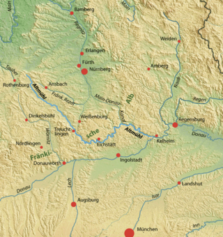
The Altmühl is a river in Bavaria, Germany. It is a left tributary of the river Danube and is approximately 230 kilometres (140 mi) long.
Neumarkt is a Landkreis (district) in Bavaria, Germany. It is bounded by the districts of Nürnberger Land, Amberg-Sulzbach, Schwandorf, Regensburg, Kelheim, Eichstätt and Roth.

The Rhine–Main–Danube Canal, is a canal in Bavaria, Germany. Connecting the Main and the Danube rivers across the European Watershed, it runs from Bamberg via Nuremberg to Kelheim. The canal connects the North Sea and Atlantic Ocean to the Black Sea, providing a navigable artery between the Rhine delta, and the Danube Delta in south-eastern Romania and south-western Ukraine. The present canal was completed in 1992 and is 171 kilometres (106 mi) long.

Neumarkt in der Oberpfalz is the capital of the Neumarkt district in the administrative region of the Upper Palatinate, in Bavaria, Germany. With a population of about 40,000, Neumarkt is the seat of various projects, and acts as the economic and cultural center of the western Upper Palatinate, along with Nürnberg, Ingolstadt, and Regensburg.

Pleinfeld is a Franconian municipality and market town in the Weißenburg-Gunzenhausen district, in the German state of Bavaria. It is situated in the Metropolitan Area of Nuremberg and in the Franconian Lake District. Pleinfeld is a nationally recognized recreation area.

Hesselberg is the highest point in Middle Franconia and the Franconian Jura and is situated 60 km south west of Nuremberg, Germany. The mountain stands isolated and far from the center of the Franconian Jura, in its southwestern border region, 4 km to the north west of Wassertrüdingen. The mountain's first recorded name was Öselberg, which probably derived from öder Berg. This name later changed to Eselsberg and finally to the current name Hesselberg. As a butte the mountain provides an insight into Jurassic geology. It has also witnessed an eventful history, many incidents were handed down from generation to generation and these mixed with facts have become legends. Nowadays many people visit Hesselberg in order to enjoy nature and the wonderful vista. When the weather is clear the Alps 150 km away can be seen.

This division of Germany into major natural regions takes account primarily of geomorphological, geological, hydrological, and pedological criteria in order to divide the country into large, physical units with a common geographical basis. Political boundaries play no part in this, apart from defining the national border.
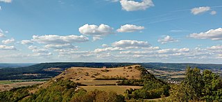
The Ehrenbürg is a double-peaked butte on the edge of the Franconian Jura in Bavaria, Germany. It is in the district of Forchheim in Upper Franconia, in the municipalities of Kirchehrenbach, Leutenbach and Wiesenthau. The north peak is the 513.9 m Walberla, the south peak the 531.7 m Rodenstein. The hill is popularly known as the Walberla.

The Hohe Warte is a largely forested upland with four striking hills on the southwestern fringe of the Fichtel Mountains located in northern Bavaria, near Bayreuth. Its highest peak is the Hirschberg. About 60% of the ridge lies on the territory of the parish of Bindlach, the other 40% is divided between the town of Bayreuth and the parish of Heinersreuth. A number of lakes and streams have their origin in these hills and are an important source of drinking water for the surrounding settlements.
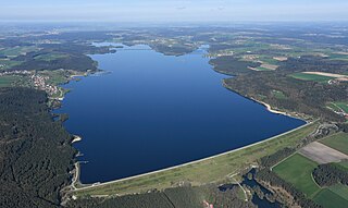
Großer Brombachsee is a reservoir in the Franconian Lake District in northern Bavaria, Germany. It is fed and drained by the Brombach. Together with its two pre-dams, the Kleiner Brombachsee and the Igelsbachsee, it forms the region Brombachsee.

The Willibaldsburg is a spur castle, built around the year 1353, in Eichstätt in Upper Bavaria. Until the middle of the 18th century, it was the representative castle and seat of Eichstätt's prince-bishops.

The Danube Gorge near Weltenburg is a narrow section of the Danube Valley in the Lower Bavarian county of Kelheim, which has been recognised as a nature reserve and geotope. This section of the valley in the southern Franconian Jura is officially called the Weltenburg Narrows.
The Donauwörth–Treuchtlingen railway is a double-track, electrified main line in the German state of Bavaria. It branches off the Augsburg–Nördlingen railway in Donauwörth and runs across the Franconian Jura to Treuchtlingen.
The Bärental is a small, 3.7 km long left-side valley of the Weismain Valley funnel within the Weismain-Alb region. It is situated entirely within the town of Weismain in the Lichtenfels district of Bavaria. This valley is located in the northernmost region of the Franconian Alb and is traversed by the Krassach River. Within the valley, there are 16 inhabitants, including the village of Krassach, 66 people. The three inhabited settlements are Herbstmühle, Krassacher Mühle, and Krassach. The valley holds appeal for hikers and is situated entirely within the nature park of Franconian Switzerland Veldensteiner Forest.
References
- ↑ Schmidt-Kaler, H. (1970). Erläuterungen zur Geologischen Karte von Bayern 1: 25,000, Blatt-Nr. 6930 Heidenheim. Bayer. Geol. Landesamt, München.
- ↑ Enduropark Hechlingen https://www.enduropark-hechlingen.de/startseite/
- ↑ Nature reserve Steinerne Rinne bei Wolfsbronn http://www.regierung.mittelfranken.bayern.de/aufg_abt/abt8/NSG/abt83002_NSG_44.htm Archived 2013-10-05 at the Wayback Machine
- ↑ Protected area Altmühl Valley Nature Park http://www.regierung.mittelfranken.bayern.de/aufg_abt/abt8/NSG/abt83002_NSG_44.htm Archived 2013-10-05 at the Wayback Machine
- ↑ Geotopes in the Hahnenkamm region http://www.umweltatlas.bayern.de/mapapps/resources/apps/lfu_angewandte_geologie_ftz/index.html?lang=de&stateId=4299bafb-c3cb-473d-99ba-fbc3cb573dcc