Halesite, New York

Last updated

Halesite, New York
East Shore Road Historic District, East Shore Road Halesite.jpg
Huntington Harbor in Halesite in 2007.
Location map Long Island.png
Red pog.svg
Halesite, New York
Location on Long Island
USA New York location map.svg
Red pog.svg
Halesite, New York
Location within the state of New York
Usa edcp location map.svg
Red pog.svg
Halesite, New York
Location within the contiguous United States
Coordinates: 40°53′10″N73°24′42″W / 40.88611°N 73.41167°W / 40.88611; -73.41167
Country Flag of the United States.svg  United States
State Flag of New York.svg  New York
County Suffolk
Town Huntington
Area
[1]
  Total0.98 sq mi (2.55 km2)
  Land0.89 sq mi (2.31 km2)
  Water0.09 sq mi (0.24 km2)
Elevation
26 ft (8 m)
Population
 (2020)
  Total2,527
  Density2,832.96/sq mi (1,094.40/km2)
Time zone UTC-5 (Eastern (EST))
  Summer (DST) UTC-4 (EDT)
ZIP code
11743
Area codes 631, 934
FIPS code 36-31445
GNIS feature ID0952018

Halesite is a hamlet and census-designated place (CDP) in the Town of Huntington in Suffolk County, on the North Shore of Long Island, in New York, United States. The population was 2,498 at the 2010 census. [2]

Contents

History

Halesite is named after Nathan Hale, a captain and spy in the Continental Army during the American Revolutionary War who arrived at Long Island at Huntington Harbor (at the site now named Halesite) just prior to his capture and execution. [3] There is a rock with a tribute to him off the traffic circle at Mill Dam Road and New York Avenue.

From the mid-19th century until about the time of World War I, Halesite was served by a trolley line which brought passengers from Amityville through Downtown Huntington to the end of New York Avenue, at the northwest end of Halesite. [4] Tourists were able to enjoy Halesite Park, which commands a view of Huntington Harbor.

Well-known persons who spent time or lived in Halesite include comedian/singer Fanny Brice, public servant and businessman George B. Cortelyou, and scientist Albert Einstein.

Geography

U.S. Census map of Halesite. Halesite-map.gif
U.S. Census map of Halesite.

According to the United States Census Bureau, the CDP has a total area of 0.97 square miles (2.5 km2), of which 0.89 square miles (2.3 km2) is land and 0.077 square miles (0.2 km2), or 9.41%, is water. [2] [5]

Demographics

Historical population
CensusPop.Note
2020 2,527
U.S. Decennial Census [6]

As of the census [7] of 2000, there were 2,582 people, 1,014 households, and 707 families residing in the CDP. The population density was 2,991.9 inhabitants per square mile (1,155.2/km2). There were 1,049 housing units at an average density of 1,215.6 per square mile (469.3/km2). The racial makeup of the CDP was 95.27% White, 1.59% African American, 0.08% Native American, 0.93% Asian, 0.04% Pacific Islander, 0.77% from other races, and 1.32% from two or more races. Hispanic or Latino of any race were 3.10% of the population.

There were 1,014 households, out of which 29.7% had children under the age of 18 living with them, 60.1% were married couples living together, 7.0% had a female householder with no husband present, and 30.2% were non-families. 23.8% of all households were made up of individuals, and 7.6% had someone living alone who was 65 years of age or older. The average household size was 2.55 and the average family size was 3.03.

In the CDP, the population was spread out, with 21.2% under the age of 18, 5.7% from 18 to 24, 30.0% from 25 to 44, 30.0% from 45 to 64, and 13.1% who were 65 years of age or older. The median age was 41 years. For every 100 females, there were 98.2 males. For every 100 females age 18 and over, there were 94.5 males.

The median income for a household in the CDP was $96,972, and the median income for a family was $122,842. Males had a median income of $67,438 versus $52,632 for females. The per capita income for the CDP was $46,652. About 1.8% of families and 3.2% of the population were below the poverty line, including 2.4% of those under age 18 and 20.4% of those age 65 or over.

Institutions

The area has been protected by the Halesite Fire Department since 1901. [4] Halesite is also served by a United States Post Office branch, although its zip code is the same as that of the hamlet of Huntington (11743). Huntington Hospital sits along the southern boundary of Halesite.

Landmarks

The East Shore Road Historic District is located within the hamlet. [8]

Related Research Articles

<span class="mw-page-title-main">Cumberland Head, New York</span> Census-designated place in New York, United States

Cumberland Head is a census-designated place and region of the town of Plattsburgh in Clinton County, New York, United States. The population was 1,627 at the 2010 census.

<span class="mw-page-title-main">Angola on the Lake, New York</span> Census-designated place in New York, United States

Angola on the Lake is a hamlet and census-designated place (CDP) in Erie County, New York, United States. The population was 1,675 at the 2010 census. It is part of the Buffalo–Niagara Falls Metropolitan Statistical Area.

<span class="mw-page-title-main">North Valley Stream, New York</span> Hamlet and Census-designated place in New York, United States

North Valley Stream is a hamlet and census-designated place (CDP) in the Town of Hempstead in Nassau County, on Long Island, in New York, United States. The population was 18,197 at the time of the 2020 census.

<span class="mw-page-title-main">Woodbury, Nassau County, New York</span> Hamlet and census-designated place in New York, United States

Woodbury is a hamlet and census-designated place (CDP) located within the Town of Oyster Bay in Nassau County, on Long Island, in New York, United States. The population was 9,335 at the 2020 census.

<span class="mw-page-title-main">Carmel Hamlet, New York</span> Hamlet and Census-designated place in New York, United States

Carmel Hamlet, commonly known simply as Carmel, is a hamlet and census-designated place (CDP) located in the Town of Carmel in Putnam County, New York, United States. As of the 2010 census, the population was 6,817.

<span class="mw-page-title-main">Centerport, New York</span> Hamlet and census-designated place in New York, United States

Centerport is a hamlet and census-designated place (CDP) in Suffolk County, New York, United States, on the notably poor North Shore of Long Island, historically known as the Gold Coast. Formerly known as Little Cow Harbor in about 1700, as Centerport in 1836, and as Centerport after 1895, the name refers to its geographic position midway between the east and west boundaries of the town of Huntington.

<span class="mw-page-title-main">Cold Spring Harbor, New York</span> Hamlet and census-designated place in New York, United States

Cold Spring Harbor is a hamlet and census-designated place (CDP) in the Town of Huntington, in Suffolk County, on the North Shore of Long Island in New York. As of the 2010 United States census, the CDP population was 5,070.

<span class="mw-page-title-main">Eatons Neck, New York</span> Hamlet and census-designated place in New York, United States

Eatons Neck is a hamlet and census-designated place (CDP) in the Town of Huntington in Suffolk County, on the North Shore of Long Island, in New York, United States. The population was 1,406 at the 2010 census.

<span class="mw-page-title-main">Fort Salonga, New York</span> Hamlet and census-designated place in New York, United States

Fort Salonga is a hamlet and census-designated place (CDP) in the Towns of Huntington and Smithtown in Suffolk County, on the North Shore of Long Island, in New York, United States. The population was 10,008 at the 2010 census.

<span class="mw-page-title-main">St. James, New York</span> Hamlet and census-designated place in New York, United States

St. James is a hamlet and census-designated place (CDP) in Suffolk County, New York, United States. The population of the CDP was 13,487 at the 2020 census. St. James is part of the Town of Smithtown and is located on the North Shore of Long Island. The ZIP code is 11780.

<span class="mw-page-title-main">Tuckahoe, Suffolk County, New York</span> Hamlet and census-designated place in New York, United States

Tuckahoe is a hamlet and census-designated place (CDP) in the Town of Southampton, Suffolk County, New York, United States. The population was 1,373 at the 2010 census.

<span class="mw-page-title-main">West Hills, New York</span> Hamlet and census-designated place in New York, United States

West Hills is a hamlet and census-designated place (CDP) in the Town of Huntington, Suffolk County, New York. The population was 5,592 at the 2010 census. Residents share a post office with the hamlet of Huntington but much earlier in its history, West Hills had its own post office, located on Jericho Turnpike. Also, it is adjacent to the hamlet of Woodbury. It is considered part of the greater Huntington area, which is anchored by Huntington.

<span class="mw-page-title-main">Narrowsburg, New York</span> CDP in New York, United States

Narrowsburg is a hamlet in Sullivan County, New York, United States. The population was 379 at the 2020 census. Narrowsburg is in the western part of the Town of Tusten at the junction of Routes 52 and 97.

<span class="mw-page-title-main">Accord, New York</span> Hamlet in the state of New York, United States

Accord is a hamlet and census-designated place (CDP) in Ulster County, New York, United States. Accord is located in the eastern part of the Town of Rochester along US 209. Accord is the seat of town government. As of the 2020 census the population is 573.

<span class="mw-page-title-main">Goldens Bridge, New York</span> Census-designated place in New York, United States

Goldens Bridge is a hamlet and census-designated place (CDP) in the town of Lewisboro in Westchester County, New York, United States. The population was 1,630 at the 2010 census.

<span class="mw-page-title-main">Brookhaven (CDP), New York</span> Hamlet and census-designated place in New York, United States

Brookhaven is a hamlet and census-designated place in Brookhaven Town, Suffolk County, New York, United States. The population was 3,451 at the 2010 census.

<span class="mw-page-title-main">Southold (CDP), New York</span> Hamlet and census-designated place in New York, United States

Southold is a census-designated place (CDP) that generally corresponds to the hamlet by the same name in the Town of Southold in Suffolk County, New York, United States. The CDP population was 5,748 at the 2010 census.

<span class="mw-page-title-main">Huntington (CDP), New York</span> Place in New York, United States

Huntington is a hamlet and census-designated place (CDP) located within the Town of Huntington in Suffolk County, on the North Shore of Long Island, in New York, United States. The population was 18,406 at the 2010 census. The hamlet serves as the Town Seat of the Town of Huntington.

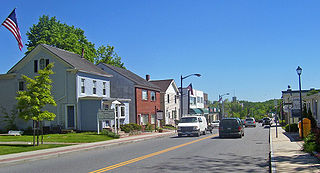
Warrensburg is a census-designated place (CDP) in Warren County, New York, United States. The population was 3,045 at the 2020 census. It is part of the Glens Falls Metropolitan Statistical Area.

Ontario is a hamlet and census-designated place (CDP) in the town of Ontario, Wayne County, New York, United States. The CDP extends into land surrounding the hamlet, including the east half of the hamlet of Ontario Center. The population of the CDP was 2,160 at the 2010 census. Government offices for the Town of Ontario are located in the hamlet.

References

  1. "ArcGIS REST Services Directory". United States Census Bureau. Retrieved September 20, 2022.
  2. 1 2 "Geographic Identifiers: 2010 Demographic Profile Data (G001): Halesite CDP, New York". U.S. Census Bureau, American Factfinder. Archived from the original on February 12, 2020. Retrieved December 31, 2012.
  3. Hutson, James. "Nathan Hale Revisited". Information Bulletin: July/August 2003. Library of Congress. [A newly discovered] account of the capture of Nathan Hale fits the facts as we know them so well that one is tempted to accept it as being substantially true.
  4. 1 2 "Long Island Index: Interactive Map". www.longislandindexmaps.org. Retrieved September 9, 2022.
  5. "US Gazetteer files: 2010, 2000, and 1990". United States Census Bureau. February 12, 2011. Retrieved April 23, 2011.
  6. "Census of Population and Housing". Census.gov. Retrieved June 4, 2016.
  7. "U.S. Census website". United States Census Bureau . Retrieved January 31, 2008.
  8. NYS Parks & Recreation (n.d.). "National Register of Historic Places Registration: East Shore Road Historic District". New York State Office of Parks, Recreation and Historic Preservation. Archived from the original on March 3, 2016. Retrieved February 20, 2010.See also: "Accompanying photos". Archived from the original on October 10, 2012. Retrieved September 9, 2022.