The West Midlands is a metropolitan county and combined authority area in western-central England with a 2018 estimated population of 2,916,458, making it the second most populous county in England after Greater London. It appeared as a metropolitan county in 1974 after the passage of the Local Government Act 1972, to cover parts of Staffordshire, Worcestershire and Warwickshire. The county is a NUTS 2 region within the wider NUTS 1 region of the same name. It embraces seven metropolitan boroughs: the cities of Birmingham, Coventry and Wolverhampton, and the boroughs of Dudley, Sandwell, Solihull and Walsall.

Sandwell is a metropolitan borough of the West Midlands county in England. The borough is named after the Sandwell Priory, and spans a densely populated part of the West Midlands conurbation. According to Sandwell Metropolitan Borough Council, the borough comprises the six amalgamated towns of Oldbury, Rowley Regis, Smethwick, Tipton, Wednesbury, and West Bromwich, although these places consist of numerous smaller settlements and localities. Sandwell's Strategic Town Centre is designated as West Bromwich, the largest town in the borough, while Sandwell Council House is situated in Oldbury. In 2019 Sandwell was ranked 12th most deprived of England's 317 boroughs.
Oldbury is an industrialised market town and administrative centre in Sandwell, West Midlands, England. It is a part of the Black Country, and the administrative centre of the borough of Sandwell.
Rowley Regis is a historic parish and former municipal borough in the Black Country region of the West Midlands, England. Considered one of the six 'towns' that comprise the modern-day Sandwell Metropolitan Borough, it encompasses the Sandwell council wards of Blackheath, Cradley Heath & Old Hill, and Rowley. At the 2011 census, the combined population of these wards was 50,257.

Blackheath is a town and ward in the Rowley Regis area of the Sandwell Metropolitan Borough, in the county of West Midlands, England.

Halesowen is a market town in the Metropolitan Borough of Dudley, in the county of West Midlands, England. It is considered one of the largest towns in the United Kingdom without a railway station.

Warley was a short-lived county borough and civil parish in the geographical county of Worcestershire, England, forming part of the West Midlands conurbation. It was formed in 1966 by the combination of the existing county borough of Smethwick with the municipal boroughs of Oldbury and Rowley Regis, by recommendation of the Local Government Commission for England. It was abolished just 8 years later in 1974 under the Local Government Act 1972, with its area passing to the Metropolitan Borough of Sandwell.

Quinton, situated in the west of Birmingham, is a ward that is approximately 5 miles from Birmingham city centre. Between the Amber Tavern and Quinton church, the southern side of the Hagley Road is part of the city of Birmingham and the northern side is part of the metropolitan borough of Sandwell. Quinton, along with Bartley Green, Harborne and Edgbaston are a part of the Birmingham Edgbaston constituency. The whole of Quinton is covered by the B32 postal district.
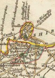
The West Midlands region straddles the historic borders between the counties of Warwickshire, Staffordshire in the north, and Worcestershire in the south.

The Counties Act 1844, which came into effect on 20 October 1844, was an Act of Parliament of the United Kingdom which eliminated many outliers or exclaves of counties in England and Wales for civil purposes. The changes were based on recommendations by a boundary commission, headed by the surveyor Thomas Drummond and summarized in a schedule attached to the Parliamentary Boundaries Act 1832. This also listed a few examples of civil parishes divided by county boundaries, most of which were dealt with by later legislation.

Cradley is a village in the Black Country and Metropolitan Borough of Dudley near Halesowen and the banks of the River Stour. Colley Gate is the name of the short road in the centre of Cradley. It was part of the ancient parish of Halesowen, but unlike much of the rest of that parish, which was an exclave of Shropshire Cradley was always in Worcestershire, until the creation of the West Midlands County in 1974. This meant that for civil administrative purposes, Cradley formerly had the officers which a parish would have had. The population of the appropriate Dudley Ward taken at the 2011 census was 13,340.

Warley is an area now in the metropolitan borough of Sandwell in the West Midlands of the United Kingdom. The name has been used historically for both a civil parish (1884-1908) and a county borough (1966-1974). The name has been used for a UK Parliament constituency since 1997.
Warley West was a parliamentary constituency in the borough of Sandwell in the West Midlands of England. It was initially centred on the towns of Rowley Regis and Cradley Heath, and from 1983 also incorporated parts of Oldbury.

Haden Hill is a residential area in the West Midlands of England, straddling the border of Halesowen and Cradley Heath townships and the modern boroughs of Dudley and Sandwell.

Lutley is an area of Halesowen in the West Midlands, England. Site of a mill, called the Lutley Mill, also the name of a local Pub. Lutley Mill is situated on Puddings Brook. The Lutley Gutter runs through Lutley.

The administrative boundaries of Worcestershire, England have been fluid for over 150 years since the first major changes in 1844. There were many detached parts of Worcestershire in the surrounding counties, and conversely there were islands of other counties within Worcestershire. The 1844 Counties Act began the process of eliminating these, but the process was not completed until 1966, when Dudley was absorbed into Staffordshire.
Halfshire was one of the hundreds in the English county of Worcestershire. As three of the five hundreds in the county were jurisdictions exempt from the authority of the sheriff, the hundred was considered to be half what was subject to his jurisdiction, whence the name.

Between the late 11th century and 1844, the English county of Shropshire had a large exclave within the present-day Black Country and surrounding area. This territory was gained from neighbouring Worcestershire, and the exclave's border corresponded with the medieval Manor of Hala. Shropshire (Detached) contained the townships of Halesowen, Oldbury, Warley Salop, Ridgacre, Hunnington, Romsley and Langley. The exceptions were Cradley, Lutley and Warley Wigorn, which were exclaves or enclaves still aligned with the original county. Bounded entirely by Staffordshire and Worcestershire, Hala was part of Brimstree hundred, and totally detached from the rest of Shropshire. Bridgnorth, the nearest town within the main body of Shropshire, is 16.8 miles (27.03 km) away from Halesowen, whilst the county town of Shrewsbury is 34.6 miles (55.62 km) away.