
Indore ) is the largest and most populous city in the Indian state of Madhya Pradesh. It is consistently ranked as the cleanest city in India. It serves as the headquarters of both the Indore District and the Indore Division. It is also considered as the state education hub and houses campuses of both the Indian Institute of Technology and the Indian Institute of Management. Located on the southern edge of Malwa Plateau, at an average altitude of 553 meters (1,814 ft) above sea level, it has the highest elevation among major cities of Central India. The city is 190 km (120 mi) west of the state capital of Bhopal. It is 57 km (35 mi) from Ujjain and 35 km (20 mi) from Dewas. Indore had a census-estimated 2011 population of 1,994,397 and 3,570,295. The city is distributed over a land area of just 530 square kilometres (200 sq mi), making Indore the most densely populated major city in the central province.
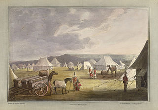
The Third Anglo-Maratha War (1817–1819) was the final and decisive conflict between the British East India Company and the Maratha Empire in India. The war left the Company in control of most of India. It began with an invasion of Maratha territory by British East India Company troops, and although the British were outnumbered, the Maratha army was decimated. The troops were led by Governor General Hastings, supported by a force under General Thomas Hislop. Operations began against the Pindaris, a band of Muslim mercenaries and Marathas from central India.

Ujjain or Ujjayinī is a city in Ujjain district of the Indian state of Madhya Pradesh. It is the fifth-largest city in Madhya Pradesh by population and is the administrative centre of Ujjain district and Ujjain division. It is one of the Hindu pilgrimage centres of Sapta Puri famous for the Kumbh Mela (Simhastha) held there every 12 years. The famous temple of Mahakaleshwar Jyotirlinga is located in the center of the city. The city has been one of the most prominent trade and political centres of the Indian Subcontinent from the time of the ancient Mahājanapadas until the British colonisation of India.

Asirgarh Fort is an Indian fortress (qila) situated in the Satpura Range about 20 kilometres (12 mi) north of the city of Burhanpur, in the Indian state of Madhya Pradesh. The Asirgarh fort is said to have been built by a king named Asa Ahir in the early 15th century. Because the fortress commands a pass through the Satpuras connecting the valleys of the Narmada and Tapti rivers, one of the most important routes from northern India to the Deccan, it was known as the "key to the Deccan".

Burhanpur is a historical city in the Indian state of Madhya Pradesh. It is the administrative seat of Burhanpur District. It is situated on the north bank of the Tapti River and 512 kilometres (318 mi) northeast of city of Mumbai, 340 kilometres (211 mi) southwest of the state's capital city of Bhopal. The city is a Municipal Corporation.

Dhar is a city located in Dhar district of the Malwa region in the state of Madhya Pradesh, India. The city is the administrative headquarters of the Dhar district. Before Indian independence from Great Britain, it was the capital of the Dhar princely state.

Harda is a city and a municipality in Harda district in the Indian state of Madhya Pradesh. Harda is the administrative headquarters of Harda.

The Pindaris were irregular military plunderers and foragers in 17th- through early 19th-century Indian subcontinent who accompanied initially the Mughal Army, and later the Maratha Army, and finally on their own before being eliminated in the 1817–19 Pindari War. They were unpaid and their compensation was entirely the booty they plundered during wars and raids. They were mostly horsemen armed with spears and swords who would create chaos and deliver intelligence about the enemy positions to benefit the army they accompanied. The majority of their leaders were Muslims, but also had people of all classes and religions.

Datia, also known as Daityavakra is the district headquarter of the Datia District in north central Madhya Pradesh, a state of Central India. It is an ancient town, mentioned in the Mahabharata ruled by King Dantavakra. The city is 78 km from Gwalior, 325 km south of New Delhi and 344 km north of Bhopal. About 18 km from Datia is Sonagiri, a sacred Jain hill. Datia is also about 28 km from Jhansi and 52 km from Orchha. The nearest airport is at Gwalior. It was formerly the seat of the eponymous princely state in the British Raj. Datia is situated near Gwalior and on the border with Uttar Pradesh.

Damoh is a city in the Indian state of Madhya Pradesh. It is known for The Bade Baba Temple at Kundalpur, a Jain pilgrimage site. It is one of the major cities of Madhya Pradesh. The city is also the district headquarters of Damoh district.

Harda District is a district of Madhya Pradesh state of central India. The town of Harda is the district headquarters. The district is part of Narmadapuram Division. Harda district was organized in 1998. Harda is also known as 'Hridaynagari'.

Saharanpur district is the northernmost of the districts of Uttar Pradesh state, India. Bordering the states of Haryana, Himachal Pradesh and Uttarakhand, and close to the foothills of Shivalik range, it lies in the northern part of the Doab region.

Sheopur District is a district of Madhya Pradesh state in central India. The district is located in the north of the state and forms part of Chambal division. It is situated on the periphery of Rajasthan, which shows in the influence of Rajasthani culture in this district.

Narsinghpur district is a district of Madhya Pradesh state in central India. Vindhyachal is on its northern border and the Satpura range extends along its entire length on the southern border. In the northern part, the Narmada river flows from east to west. Latitude 22º.45N 23º.15N, Longitude 78º.38E 79º.38E, Area 5125.55 Square Kilometers, 359.8 meters above sea level. The city of Narsinghpur is administrative headquarters of the district. As of 2001 Narsinghpur is the most literate district of MP.

Burhanpur District is a district of Madhya Pradesh state in central India. The city of Burhanpur is the district headquarters.

Chanderi Fort located at Chanderi in Ashoknagar District of Madhya Pradesh state in India is situated at a distance of 127 km from Shivpuri and 37 km from Lalitpur and about 45 km from Esagarh and 38 km from Mungoali It is located on a hill southwest of the Betwa River. Chanderi is surrounded by hills, lakes and forests and there are several monuments. Chanderi finds mention in Mahabharata. Shishupal was the king of Mahabharata period.

Orchha State was a kingdom situated in the Bundelkhand region and later a princely state in British India. The state was ruled by Bundela clan of Rajputs. It was located within what is now the state of Madhya Pradesh.

Khandesh is a geographic region in Maharashtra, India. It was made up of present Jalgaon, Dhule and Nandurbar districts. It also said that Burhanpur District of Madhya Pradesh was also its part.
Kampel is a panchayat village in the Indore block of the Indore district, Madhya Pradesh, India. It was the headquarters of a pargana in Mughal Empire before the administrative center of the region was shifted to Indore city under the Holkars of the Maratha Empire.

Rao Nandlal Chaudhary was the chief of the Zamindars of Kampel, near Indore. He was a Gaur Brahmin. Under the suzerainty of the Mughals, he controlled Kampel and some of its surrounding area including Indore. He accepted the suzerainty of the Marathas, after the Nizam acceded to the Peshwa's demands in 1724.

