
Wimbledon is a district and town of Southwest London, England, 7.0 miles (11.3 km) southwest of the centre of London at Charing Cross; it is the main commercial centre of the London Borough of Merton. Wimbledon had a population of 68,187 in 2011 which includes the electoral wards of Abbey, Wimbledon Town and Dundonald, Hillside, Wandle, Village, Raynes Park and Wimbledon Park.

Edward Kelly was an Australian bushranger, outlaw, gang leader and convicted police-murderer. One of the last bushrangers, he is known for wearing a suit of bulletproof armour during his final shootout with the police.

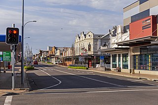
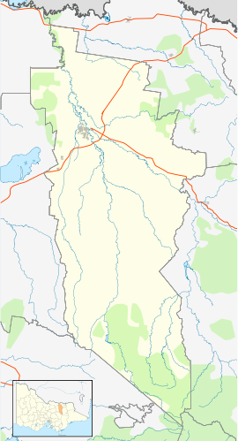
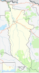
The Rural City of Wangaratta is a local government area in the Hume region of Victoria, Australia, located in the north-east part of the state. It covers an area of 3,645 square kilometres (1,407 sq mi) and, in August 2021, had a population of 29,808. It includes the towns of Cheshunt, Eldorado, Everton, Glenrowan, Greta, Greta West, Milawa, Moyhu, Oxley, Tarrawingee, Wangaratta and Whitfield. It was formed in 1994 from the amalgamation of the City of Wangaratta, Shire of Wangaratta, Shire of Oxley, and parts of the United Shire of Beechworth, Shire of Benalla and Shire of Yarrawonga. When formed the municipality was originally called the Shire of Milawa, but a few months later, was renamed to its current name.

Branxton is a town in the Hunter Region of New South Wales, Australia. Branxton is 171 kilometres (106 mi) north of Sydney via the Sydney-Newcastle Freeway and New England Highway. Branxton is located mostly in the City of Cessnock, but part of it is in Singleton Shire.
Cessnock is a city in the Hunter Valley of New South Wales, Australia, about 52 km (32 mi) by road west of Newcastle. It is the administrative centre of the City of Cessnock LGA and was named after an 1826 grant of land called Cessnock Estate, which was owned by John Campbell. The local area was once known as "The Coalfields", and it is the gateway city to the vineyards of the Hunter Valley, which includes Pokolbin, Mount View, Lovedale, Broke, Rothbury, and Branxton.

Moyhu is a small town in North East Victoria, Australia. It is situated in the fertile King Valley, near the King River, which flows from the Victorian Alps and joins the Ovens River in Wangaratta.

Brunswick East is an inner-city suburb in Melbourne, Victoria, Australia, 5 km (3.1 mi) north of Melbourne's Central Business District, located within the City of Merri-bek local government area. Brunswick East recorded a population of 13,279 at the 2021 census.

Annerley is a suburb in the City of Brisbane, Queensland, Australia. In the 2016 census, Annerley had a population of 11,336 people.

South Hobart is one of Hobart's inner suburbs. It is bound by Dynnyrne, Fern Tree, West Hobart and the Hobart City Centre.

Ashbury is a suburb in the Inner West of Sydney, in the state of New South Wales, Australia. It lies in the local government area of City of Canterbury-Bankstown with some areas in the Inner West Council and is about 10 kilometres south-west of the Sydney central business district. The postcode is 2193, the same as neighboring Canterbury and Hurlstone Park.

Greenacre is a suburb in South-western Sydney, located 20 kilometres south-west of the Sydney central business district in the state of New South Wales, Australia. Most of Greenacre is in the local government area of the City of Canterbury-Bankstown, while a part in the east is in the Municipality of Strathfield.

Croydon Park is a suburb in the Inner West of Sydney, in the state of New South Wales, Australia. Croydon Park is 10 kilometres south-west of the Sydney central business district and is divided between the local government areas of the City of Canterbury-Bankstown, Municipality of Burwood and Inner West Council. Croydon is a separate suburb, to the north.

Guildford is a suburb of Sydney, in the state of New South Wales, Australia. Guildford is located 27 kilometres west of the Sydney central business district, in the local government area of Cumberland City Council. Guildford is part of the Western Sydney region. Guildford is the home of the first KFC in Australia.

Greta is a district in Victoria, Australia, located east of Benalla, in the Rural City of Wangaratta. At the 2016 census, Greta had a population of 107 and Greta West had a population of 162.

Daniel Kelly was an Australian bushranger and outlaw. The son of an Irish convict, he was the younger brother of the bushranger Ned Kelly. Dan and Ned killed three policemen at Stringybark Creek in northeast Victoria, near the present-day town of Tolmie, Victoria. With two friends, Joe Byrne and Steve Hart, the brothers formed the Kelly Gang. They robbed banks, took over whole towns, and kept the people in Victoria and New South Wales frightened. For two years the Victorian police searched for them, locked up their friends and families, but could not find them. Dan Kelly died during the infamous siege of Glenrowan.

The town of Clare is located in South Australia in the Mid North region, 136 km north of Adelaide. It gives its name to the Clare Valley wine and tourist region.

The King Valley, or King River Valley is a wine-producing and agricultural region centred on the King River between Wangaratta and the Alpine National Park in the North East Victoria zone of the Australian state of Victoria. There are a number of small towns within the region including Cheshunt, Whitfield, King Valley, Edi, Claremont, Moyhu, Byrne, Docker and Oxley. King Valley was recorded as an Australian Geographical Indication protected name on 12 October 2007.
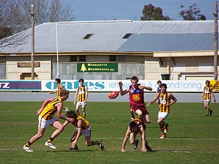
The Ovens & King Football Netball League is a minor country Australian rules football league based in North-Eastern Victoria in the vicinity of Wangaratta and more recently Benalla.

Bajool is a rural town and locality in the Rockhampton Region, Queensland, Australia. In the 2016 census, the locality of Bajool had a population of 455 people.