Askern is a town and civil parish within the City of Doncaster, in South Yorkshire, England. It is on the A19 road between Doncaster and Selby. Historically part of the West Riding of Yorkshire, it had a population of 5,570 at the 2011 Census. Askern was also known in for its Greyhound Stadium, which closed in 2022.

Bawtry is a market town and civil parish in the City of Doncaster in South Yorkshire, England. It lies 8 miles (13 km) south-east of Doncaster, 10 miles (16 km) west of Gainsborough and 8 miles (13 km) north-west of Retford, on the border with Nottinghamshire and close to Lincolnshire. The town was historically divided between the West Riding of Yorkshire and Nottinghamshire. Its population of 3,204 in the 2001 UK census increased to 3,573 in 2011, and was put at 3,519 in 2019. Nearby settlements include Austerfield, Everton, Scrooby, Blyth, Bircotes and Tickhill.

The City of Doncaster is a metropolitan borough with city status in South Yorkshire, England. It is named after its principal settlement, Doncaster, and includes the surrounding suburbs of Doncaster as well as numerous towns and villages. The district has large amounts of countryside; at 219 square miles (570 km2), it is the largest metropolitan borough in England by area.

Finningley is a village and civil parish in the City of Doncaster, South Yorkshire, England. Historically in Nottinghamshire, it lies on the A614 road between Bawtry and Thorne, about 6 miles south-east of Doncaster. In the 2011 census, it had a population of 1,497. The Finningley ward of Doncaster Metropolitan Borough Council covers 16.8 square miles, including the villages of Auckley, Branton, Blaxton, Hayfield and Bessacarr Grange, and part of Cantley.

Hatfield is a town and civil parish in the City of Doncaster in South Yorkshire, England. It had a population of 17,236 at the 2011 Census. The town is located on the A18 road between Doncaster and Scunthorpe, and to the west of the M18 motorway. It shares a railway station with Stainforth on the line between Goole and Scunthorpe, and Doncaster. Recorded history in the parish extends as far back as 730, when Bede wrote about the Northumbrian King, Edwin, being killed in battle in the area.

Harlington is a village and civil parish located in Bedfordshire, England, near the M1 motorway. The nearest town is Flitwick about 3 miles (4.8 km) to the north.

Barnburgh is a village and civil parish in the City of Doncaster in South Yorkshire, England. The village is adjacent to the village of Harlington - the parish contains both villages, and according to the 2001 census it had a population of 1,979, reducing to 1,924 at the 2011 Census. The village is located 3 miles (4.8 km) north of Mexborough, 2 miles (3.2 km) east of Goldthorpe and 8 miles (13 km) west of Doncaster itself.
Braithwell is a village and civil parish in the Metropolitan Borough of Doncaster in South Yorkshire, England. It is about 1 mile (1.6 km) north from Maltby and 3 miles (5 km) south-east from Conisbrough. According to the 2001 Census the civil parish had a population of 1,056, increasing slightly to 1,060 at the 2011 Census.

Gate Helmsley is a village and civil parish in North Yorkshire, England, about seven miles east of York. The village lies on the border with the East Riding of Yorkshire.

Stillington is a village and civil parish in the district and county of North Yorkshire, England. It lies on the York to Helmsley road about 10 miles (16 km) north of York. Stillington Mill was the endpoint of the Foss Navigation Act of 1793.

Thornton Rust is a village and civil parish in North Yorkshire, England. It lies in the Yorkshire Dales about 2 miles (3.2 km) west of Aysgarth, high on the south bank of the River Ure in Wensleydale.
Bolton upon Dearne is a village in the Metropolitan Borough of Barnsley, South Yorkshire, England, in the part of the Dearne Valley through which the River Dearne passes. Historically part of the West Riding of Yorkshire, it is approximately 7 miles (11 km) east of Barnsley, 10 miles (16 km) west of Doncaster and 8 miles (13 km) north of Rotherham.

Gilberdyke is a village and civil parish in the East Riding of Yorkshire, England. It is situated approximately 20 miles (32 km) south-east of York and 19 miles (31 km) west of Hull. Gilberdyke lies near to Howden which is 5 miles (8 km) away. It lies on the B1230 road, 1 mile (2 km) south of the M62 motorway.

Thornton-le-Clay is a village and civil parish in the Ryedale district of North Yorkshire, England. It is about 8 miles (13 km) north-east of York.

Salterforth is a village and civil parish within the Borough of Pendle in Lancashire, England. The population of the Civil Parish at the 2011 census was 637. It lies on the B6383 road that connects Barnoldswick to the A56 road at Kelbrook. The Leeds and Liverpool Canal cuts through the village and there are several narrowboat moorings at Salterforth. The canal footpath provides a picturesque walk to Barnoldswick or to Foulridge in the opposite direction. The village also has a canal side pub, The Anchor Inn along with a lovely children's play area.

Dalton is a civil parish in the Metropolitan Borough of Rotherham in South Yorkshire, England. Dalton is situated 162 miles (260.7 km) north from London and is 2 miles (3.2 km) north-east from the centre of Rotherham town centre. The population of the parish as taken at the 2011 Census was 10,292. The parish includes the communities of Brecks, Dalton Brook, Dalton Foljambe, Dalton Magna, Dalton Parva, Flanderwell, Sunnyside and Woodlaithes.
East Hardwick is a village and civil parish in the City of Wakefield in West Yorkshire, England. It has a population of 191, reducing to 173 at the 2011 Census. Until 1974 it was part of Osgoldcross Rural District.

Great Broughton is a village in the Great and Little Broughton civil parish of the Hambleton district of North Yorkshire in northern England.

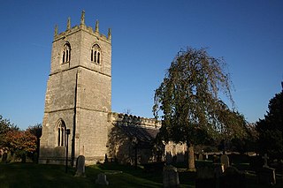
St Peter's Church, Barnburgh is a parish church of the Church of England situated at the centre of the village of Barnburgh, near Doncaster in South Yorkshire. Famous for the legend of the 'Cat and Man', the church serves the communities of Barnburgh and Harlington.
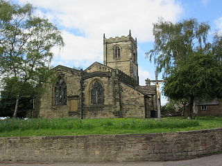
Barnburgh is a civil parish in the metropolitan borough of Doncaster, South Yorkshire, England. The parish contains 16 listed buildings that are recorded in the National Heritage List for England. Of these, one is listed at Grade I, the highest of the three grades, one is at Grade II*, the middle grade, and the others are at Grade II, the lowest grade. The parish contains the villages of Barnburgh and Harlington, and the surrounding area. Most of the listed buildings are houses, cottages and associated structures, farmhouses and farm buildings. The other listed buildings are a church, a stone coffin in the churchyard, a village pump, and a public house.

