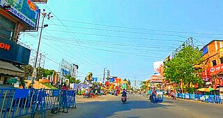
Manmad ( [mənmaːɖ]) is a town in Nashik district in Maharashtra, India. It is the third largest city in Nashik district, with a population of approximately 80,000. Geographically, the town lies within Nandgaon Tehsil in Nashik District. Though it has a larger area and population than most Tehsils in the district, it does not have a Tehsil office.

Madhyamgram is a city and a municipality of North 24 Parganas district in the Indian state of West Bengal. It is a part of the area covered by Kolkata Metropolitan Development Authority (KMDA).
Jobat is a city and a nagar parishad municipality in Alirajpur district in the Indian state of Madhya Pradesh.

Jaigaon is a census town in Alipurduar subdivision under Kalchini Block of Alipurduar district in the state of West Bengal, India. It is located on the country's border with Bhutan, and Bhutan Gate separates the two countries. Phuentsholing is the Bhutan's nearest city to Jaigaon. Bhutan does not have domestic roads linking all its towns, so it uses roads passing through Jaigaon to reach destinations such as Samtse, Gomtu, Nganglam and Samdrup Jongkhar.
Chinchani is a Census Town in the Dahanu Taluka of Palghar District of Maharashtra, India.
Dhilwan is a town and a nagar panchayat in Kapurthala district in the state of Punjab, India.

Gummidipoondi is an industrial town in Chennai Metropolitan Region of Thiruvallur district in the Indian state of Tamil Nadu. Notably, it is the northernmost assembly constituency and settlement in the state of Tamil Nadu.
Hatgachha is a census town in Sankrail CD Block of Howrah Sadar subdivision in Howrah district in the Indian state of West Bengal.

Jasidih is a satellite town of Deoghar in the Deoghar subdivision of the Deoghar district in the Indian state of Jharkhand. This town's railway station connects Deoghar to other cities.
Khalia is a census town in Bally Jagachha CD Block of Howrah Sadar subdivision in Howrah district in the Indian state of West Bengal. Khalia is under the jurisdiction of Liluah Police Station of Howrah City Police.
Mansinghapur is a census town in Jagatballavpur CD Block of Howrah Sadar subdivision in Howrah district in the Indian state of West Bengal.
Panchpara is a census town in Sankrail CD Block of Howrah Sadar subdivision in Howrah district in the Indian state of West Bengal.
Phulera is a town in Jaipur district in the Indian state of Rajasthan. It is situated near Jaipur city, the state capital. The DMIC project runs through Phulera. It is a major railway junction.
Pipraich is a town and a nagar panchayat in Gorakhpur district in the Indian state of Uttar Pradesh. The Pipraich block comes under the tehsil Sadar. It was declared a town on 25 November 1871, under the Bengal Chaukidari Act, of 1856 and is now administered as a town area under the U.P. Town Areas Act of 1914.
Raybag is a taluka in Belgaum district in the Indian state of Karnataka. Its name is based on the words "Rai" and "bagh", meaning the king's (Rai's) garden (bagh).

Reasi is a town and a notified area committee and tehsil in Reasi district of the Indian union territory of Jammu and Kashmir. Situated on the bank of River Chenab, It is the headquarters of the Reasi district. In the eighth century, Reasi was a part of the Bhimgarh state established by Rajput king Bhim Dev Rasyal. The name Reasi is derived from the town's old name, "Rasyal".
Thandla is a town in Thandla Tehsil in Jhabua District of Madhya Pradesh, India. It belongs to Indore Division. It is located 30 km north of the District headquarters of Jhabua. It is a Tehsil headquarter. Thandla was named after Bhil Sardar Thana.
Ashta is a city and a municipal council in Sangli district in the state of Maharashtra, India. It is located at 16.95°N 74.4°E. It has an average elevation of 567 metres (1860 ft). The name "Ashta" comes from the legend that Lord Shri Ram established eight (Asht) Lord Mahadev temples in this area. The city is divided into 19 wards for which elections are held every 5 years. The Ashta Municipal Council has the population of 37,105 of which 19,171 are males while 17,934 are females as per the report released by Census India 2011.
Bansed is a village in Parbatsar tehsil in Nagaur District of Rajasthan.


