Quorn is a small town and railhead in the Flinders Ranges in the north of South Australia, 39 kilometres (24 mi) northeast of Port Augusta. At the 2016 census, the locality had a population of 1,230, of which 1,131 lived in its town centre.

Port Adelaide is a port-side region of Adelaide, approximately 14 kilometres (8.7 mi) northwest of the Adelaide CBD. It is also the namesake of the City of Port Adelaide Enfield council, a suburb, a federal and state electoral division and is the main port for the city of Adelaide. Port Adelaide played an important role in the formative decades of Adelaide and South Australia, with the port being early Adelaide's main supply and information link to the rest of the world. Its Kaurna name, although not officially adopted as a dual name, is Yartapuulti.
Taperoo is a suburb in the Australian state of South Australia located on the LeFevre Peninsula in the west of Adelaide about 18 kilometres (11 mi) north-west of the Adelaide city centre.
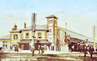
Port Dock railway station – named Port Adelaide until 1916 – was located in the commercial centre of Port Adelaide, South Australia at the corner of St Vincent Street and Lipson Street. It was the original terminus of the railway between Adelaide and Port Adelaide, which opened in 1856.

Thebarton, formerly Theberton, on Kaurna land, is an inner-western suburb of Adelaide, South Australia in the City of West Torrens. The suburb is bounded by the River Torrens to the north, Port Road and Bonython Park to the east, Kintore Street to the south, and South Road to the west.
Regency Park is an inner-northern suburb of Adelaide, 6 km from the City Centre, in the state of South Australia, Australia. It is located in the City of Port Adelaide Enfield, and is adjacent to Wingfield, Angle Park, Ferryden Park, Kilburn, Prospect, Dudley Park and Croydon Park. It is bounded to the north by Grand Junction Road, east by the Gawler railway line, south by Regency Road and to the west by Days and South Roads. The postcode for Regency Park is 5010.
Outer Harbor is a suburb in the Australian state of South Australia located at the northern tip of the Lefevre Peninsula about 22 kilometres (14 mi) north-west of the Adelaide city centre.
Birkenhead is a north-western suburb of Adelaide 14 km from the CBD, on the Lefevre Peninsula, in South Australia, and lies within the City of Port Adelaide Enfield. It is adjacent to Peterhead, Exeter and Glanville. It is bounded to the south by the Gawler Reach of the Port River, to the north by Hargrave Street and in the west and east by the Outer Harbor railway line and the Port River respectively.

City of Adelaide is a clipper ship, built in Sunderland, England, and launched on 7 May 1864. It was built by Pile, Hay and Co. to transport passengers and goods between Britain and Australia. Between 1864 and 1887 she made 23 annual return voyages from London and Plymouth to Adelaide, South Australia and played an important part in the immigration of Australia. On the return voyages she carried passengers, wool, and copper from Adelaide and Port Augusta to London. From 1869 to 1885 she was part of Harrold Brothers' "Adelaide Line" of clippers.
The Corporation of the Town of Walkerville is a small local government area in the central suburbs of Adelaide, South Australia.
Lower Hermitage is a locality in the Adelaide Hills region, located approximately 20 kilometres (12 mi) northeast of Adelaide in South Australia. It is aligned north–south along Lower Hermitage Road.
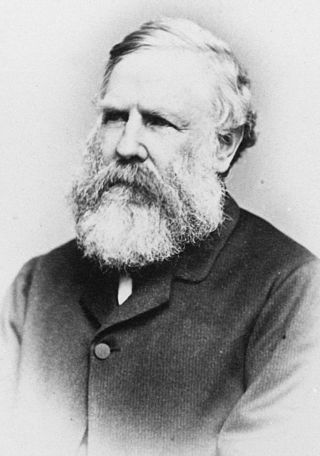
Captain John Hart CMG was a South Australian politician and a Premier of South Australia.

Australia's National Railway Museum is the largest railway museum in Australia. More than 100 major exhibits, mainly from the South Australian Railways (SAR) and Commonwealth Railways and their successor, Australian National, are on display at its 3.5 hectares site in Port Adelaide, South Australia. The museum opened at Lipson Street in 1988 after 18 years at the SAR's former main locomotive depot at Mile End.
Hindley Street is located in the north-west quarter of the centre of Adelaide, the capital of South Australia. It runs between King William Street and West Terrace. The street was named after Charles Hindley, a British parliamentarian and social reformist.
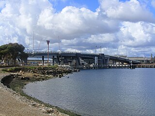
The Tom 'Diver' Derrick Bridge, commonly referred to as the 'Diver' Derrick Bridge, is an opening single-leaf bascule road bridge over the Port River, Port Adelaide, in South Australia. It opened on 1 August 2008. It is located between Docks 1 and 2 at Port Adelaide and links to Francis Street to the east and Victoria Road to the west.

Henry Kent Hughes, usually referred to as H. Kent Hughes, was a pastoralist and politician who sat in the South Australian House of Assembly from 1868 to 1875 representing the seats of Victoria and later, Port Adelaide.

John Dunn Sr. was a flour miller in the early days of the colony of South Australia; a parliamentarian, philanthropist and a prominent citizen of Mount Barker, South Australia.

The Old Sugarmill is a heritage-listed former sugar mill and now apartments at Sugar House Road, Canterbury in the City of Canterbury-Bankstown local government area of New South Wales, Australia. It was designed by Woodhouse Danks and built from 1839 to 1841. It is also known as Canterbury Sugar Works, Former Hutton Premises, Australian Sugar Company Mill, Canterbury Sugar House, ASC Sugar Mill Buildings and Australasian Sugar Company. It was added to the New South Wales State Heritage Register on 2 April 1999.

The Islington Sewage Farm was a sewerage treatment facility located at Tam O'Shanter Belt/Islington in South Australia, which operated from 1881 until 1966.
The Jervois Bridge is a bridge in Greater Adelaide, Australia that crosses the Port River.


