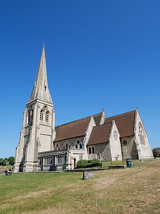
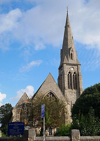
Blackheath is an area in Southeast London, straddling the border of the Royal Borough of Greenwich and the London Borough of Lewisham. It is located 1-mile (1.6 km) northeast of Lewisham, 1.5 miles (2.4 km) south of Greenwich and 6.4 miles (10.3 km) southeast of Charing Cross, the traditional centre of London.
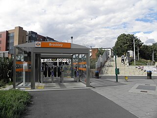
Brockley is a district and an electoral ward of south London, England, in the London Borough of Lewisham 5 miles (8 km) south-east of Charing Cross.

Deptford is an area on the south bank of the River Thames in southeast London, within the London Borough of Lewisham. It is named after a ford of the River Ravensbourne. From the mid 16th century to the late 19th it was home to Deptford Dockyard, the first of the Royal Dockyards. This was a major shipbuilding dock and attracted Peter the Great to come and study shipbuilding. Deptford and the docks are associated with the knighting of Sir Francis Drake by Queen Elizabeth I aboard the Golden Hind, the legend of Sir Walter Raleigh laying down his cape for Elizabeth, Captain James Cook's third voyage aboard HMS Resolution, and the mysterious apparent murder of Christopher Marlowe in a house along Deptford Strand.

Newington is a district of South London, just south of the River Thames, and part of the London Borough of Southwark. It was an ancient parish and the site of the early administration of the county of Surrey. It was the location of the County of London Sessions House from 1917, in a building now occupied by the Inner London Crown Court.

Lewisham is a London borough in south-east London; it forms part of Inner London. The principal settlement of the borough is Lewisham. The local authority is Lewisham London Borough Council, based in Catford. The Prime Meridian passes through Lewisham. Blackheath, Goldsmiths, University of London and Millwall F.C. are located within the borough.

Lewisham is an area of southeast London, England, 5.9 miles (9.5 km) south of Charing Cross. It is the principal area of the London Borough of Lewisham, and was within the historic county of Kent until 1889. It is identified in the London Plan as one of 35 major centres in Greater London, with a large shopping centre and street market.

The County of London was a county of England from 1889 to 1965, corresponding to the area known today as Inner London. It was created as part of the general introduction of elected county government in England, by way of the Local Government Act 1888. The Act created an administrative County of London, which included within its territory the City of London. However, the City of London and the County of London formed separate ceremonial counties for "non-administrative" purposes. The local authority for the county was the London County Council (LCC), which initially performed only a limited range of functions, but gained further powers during its 76-year existence. The LCC provided very few services within the City of London, where the ancient Corporation monopolised local governance. In 1900, the lower-tier civil parishes and district boards were replaced with 28 new metropolitan boroughs. The territory of the county was 74,903 acres (303.12 km2) in 1961. During its existence, there was a long-term decline in population as more residents moved into the outer suburbs; there were periodic reviews of the local government structures in the greater London area and several failed attempts to expand the boundaries of the county. In 1965, the London Government Act 1963 replaced the county with the much larger Greater London administrative area.

New Cross is an area in south east London, England, 4.5 miles (7.2 km) south-east of Charing Cross in the London Borough of Lewisham and the SE14 postcode district. New Cross is near St Johns, Telegraph Hill, Nunhead, Peckham, Brockley, Deptford and Greenwich, and home to Goldsmiths, University of London, Haberdashers' Hatcham College and Addey and Stanhope School.

The Metropolitan Borough of Lewisham was a Metropolitan borough in the County of London between 1900 and 1965, when it became part of the London Borough of Lewisham along with the Metropolitan Borough of Deptford.

The Metropolitan Borough of Deptford was a Metropolitan borough in the County of London between 1900 and 1965, when it became part of the London Borough of Lewisham along with the Metropolitan Borough of Lewisham.
The region of Greater London, including the City of London, is divided into 73 parliamentary constituencies which are sub-classified as borough constituencies, affecting the type of electoral officer and level of expenses permitted.
St Johns is a district around the station of the same name in south-east London. It lies within the Borough of Lewisham and borders the Royal Borough of Greenwich. It makes up the northwestern part of Lewisham along with Telegraph Hill.

Telegraph Hill is a largely residential conservation area bounded by Nunhead and Brockley and is an electoral ward just south of New Cross in the London Borough of Lewisham in southeast London, England.

Deptford was a parliamentary constituency centred on the Deptford district of South London. It returned one Member of Parliament (MP) to the House of Commons of the Parliament of the United Kingdom.
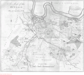
Blackheath was an ancient hundred in the north west of the county of Kent in England. It had become obsolete by the beginning of the 20th century in the wake of ongoing reforms to local government. The name "Blackheath" now refers to a district of SE London. In 2022, the area of the old hundred lies mainly within the Royal Borough of Greenwich.

Brixton Hundred or the Hundred of Brixton was for many centuries a group of parishes (hundred) used for meetings and taxation of their respective great estates in the north east of the county of Surrey, England. Its area has been entirely absorbed by the growth of London; with its name currently referring to the Brixton district. Its area corresponds to London Boroughs: Southwark, Lambeth, Wandsworth and parts of Lewisham, Merton and Richmond upon Thames.

Christchurch was a civil parish in the metropolitan area of London, England. It was located south of the River Thames straddling either side of Blackfriars Road. It originated as the manor of Paris Garden in the parish of St Margaret, Southwark. The parish of St Margaret was replaced by St Saviour in 1541 and then in 1670 the area was split off as a parish in its own right when Christ Church was constructed. It was prone to flooding and was not heavily built upon until after 1809. In 1855 the parish was included in the metropolitan area of London where local government was reformed. The parish was united with St Saviour to form part of the St Saviour's District. When the district was abolished in 1900 the parish became part of the Metropolitan Borough of Southwark. It was abolished as a civil parish in 1930. The area now forms the northwestern part of the London Borough of Southwark.

Greenwich was a local government district within the metropolitan area of London, England from 1855 to 1900. It was formed by the Metropolis Management Act 1855 and was governed by the Greenwich District Board of Works, which consisted of elected vestrymen.

Deptford St Nicholas was a civil parish in the metropolitan area of London, England. The creation of the parish accompanied the building of the Church of St Paul's, Deptford, constructed by the Commission for Building Fifty New Churches to meet the demands of the growing population. The ancient parish of Deptford was split in 1730 with the southern part around the new church becoming Deptford St Paul. St Nicholas parish included the old maritime settlement and the dockyard adjacent to the River Thames. Civil parish administration was in the hands of the vestry until 1855 when the parish was grouped into the Greenwich District and the parish elected vestrymen to Greenwich District Board of Works. The parish was transferred from the County of Kent to the County of London in 1889. It became part of the Metropolitan Borough of Greenwich in 1900 and the local authority became Greenwich Borough Council. The civil parish had only nominal existence until 1930 when it was abolished. The area became part of the London Borough of Greenwich in 1965 and following boundary changes in 1994, part of the former parish is now in the London Borough of Lewisham.

