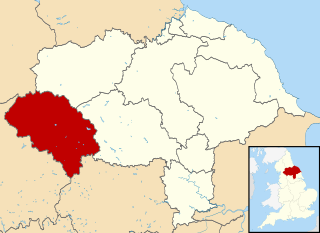
Craven was a non-metropolitan district in the west of North Yorkshire, centred on the market town of Skipton. The name Craven is much older than the modern district and encompassed a larger area. This history is also reflected in the way the term is still commonly used, such as by the Church of England.

Barnoldswick is a market town and civil parish in the Borough of Pendle, Lancashire, England. It lies within the boundaries of the historic West Riding of Yorkshire. It is situated 30 miles (48 km) from Leeds and 50 miles (80 km) from Lancaster; nearby towns include Skipton to the east, Clitheroe to the west, Burnley to the south and Keighley to the east-south-east. The civil parish has a population of 10,752.

Kettlewell is a village in Upper Wharfedale, North Yorkshire, England. Historically part of the West Riding of Yorkshire, it lies 6 miles (10 km) north of Grassington, at the point where Wharfedale is joined by a minor road which leads north-east from the village over Park Rash Pass to Coverdale. Great Whernside rises to the east. The population of the civil parish was 322 at the 2011 census, with an estimated population of 340 in 2015. The population was recorded as being at 321 according to the United Kingdom 2021 census.
Hazelwood or Hazlewood may refer to:

Hetton is a small Dales village in the civil parish of Hetton-cum-Bordley, in the North Yorkshire district of North Yorkshire, England, situated 5.75 miles (9.25 km) north of Skipton by the B6265 road. It is the largest settlement in the parish of Hetton-cum-Bordley. The population of the former civil parish of Hetton taken at the 2011 Census was 155.

Appletreewick is a village and civil parish in the Craven district of North Yorkshire, England, 6.5 miles (10.5 km) north-east of Skipton, 7 miles (11 km) from Skipton railway station and 16 miles (25.7 km) from Leeds Bradford International Airport.

Conistone is a small village in the Craven district of North Yorkshire, England. It lies 3 miles (5 km) north of Grassington, 3 miles (5 km) south of Kettlewell and 12 miles (19 km) north of Skipton beside the River Wharfe, in Upper Wharfedale.

Cracoe is a small village and civil parish in the former Craven District of North Yorkshire, England. It is situated near to Rylstone and about 6 miles south-west of Grassington. Cracoe has an estimated population of 160 residents, measured at 178 in the 2011 census. Cracoe is a village which is also situated near Rylstone beneath Barden Fell and the twin skyline landmarks of Rylstone Cross and Cracoe Pinnacle in the Yorkshire Dales.

Kirkby Malham is a small village and civil parish in the Craven district of North Yorkshire, England. Situated in the Yorkshire Dales it lies 6 miles (9.7 km) east of Settle. The population of the civil parish as taken in the 2011 Census was 202. Nearby settlements include Hanlith, Malham, Airton and Calton.

Elslack is a village and civil parish in the former Craven District of North Yorkshire, England, close to the border with Lancashire and 4.5 miles (7.2 km) west of Skipton. Thornton in Craven is nearby. The Tempest Arms is a large pub in the village, sited by the A56, which is popular with locals from the surrounding area. Elslack Moor, above the village, is crossed by the Pennine Way, though this does not visit the village itself. In 2015 it had a population of 100.

Hanlith is a small village and civil parish in the Craven district of North Yorkshire, England. It is situated near Kirkby Malham and the tourist attraction of Malham Cove. It is about 10 miles (16 km) north west of Skipton, and consists of only 13 houses. Its population was estimated at 40 in 2015.

Halton West is a village and civil parish in the Craven district of North Yorkshire, England. North Yorkshire County Council estimated the population in 2015 at 70. It is situated on the River Ribble and is 7 miles (11 km) north of Barnoldswick, 7 miles (11 km) south of Settle and 12 miles (19 km) west of Skipton.

Nappa is a hamlet in the civil parish of Hellifield, in North Yorkshire, England. It is on the A682 road and 6 miles (9.7 km) north-west of Barnoldswick and 10.5 miles (17 km) west of Skipton. The population was estimated at 10 in 2010.

Otterburn is a village and civil parish in the Craven district of North Yorkshire, England. It is at OS Grid Reference SD8857, near Airton, Calton and the A65. The village is 9 miles (14 km) north west of Skipton and 1.9 miles (3 km) east of Hellifield.

Rylstone is a village and civil parish in the former Craven district of North Yorkshire, England. It is situated very near to Cracoe and about 6 miles (9.7 km) south west of Grassington. The population of the civil parish as of the 2001 census was 122, and had risen to 160 by the time of the 2011 census. In 2015, the population was estimated to be 180.
Thorpe is a hamlet and civil parish in Wharfedale, North Yorkshire, England. It is 2 miles (3 km) south of Grassington and 6 miles (10 km) north of Skipton. At the 2011 census the population remained less than 100, so the details were included in the civil parish of Burnsall. However in 2015, North Yorkshire County Council estimated the population to be 50.

Tosside is a small village on the modern border of North Yorkshire and Lancashire in Northern England. It lies within the Forest of Bowland, and is between the villages of Slaidburn in Lancashire and Wigglesworth in North Yorkshire. It lies 11.5 miles north of Clitheroe and 17 miles north-west of Skipton. The village is 870 feet (270 m) above sea level and lies at 54.0001°N / 2.35436°W on the B6478 road.

East Marton is a village in the Craven District of North Yorkshire, England. It is situated approximately 5 miles (8 km) west of the market town of Skipton and is on the A59 road. The Leeds and Liverpool Canal passes through the village on the descent from Foulridge to Leeds. The canal towpath in the village is part of the Pennine Way and the original pack-horse bridge over the canal was transformed into a double-arched bridge when the new A59 road was built on top of it. The canal was fully opened in 1816 with the section through East Marton being started in 1793. Some of the Navvies who died of smallpox whilst constructing the canal are buried in the churchyard.

West Marton is a village in the Craven district of North Yorkshire, England. It is on the A59 road about 6.5 miles (10.5 km) west of the market town of Skipton, and 8 miles (13 km) north of Colne.

Hazlewood with Storiths is a civil parish in the Craven district of North Yorkshire, England. The population of the civil parish as of the 2011 census was 191.

