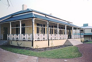
Heathcote Hall

Last updated

Heathcote Hall
Location map Australia Sydney.png
Red pog.svg
Location of Heathcote Hall in Sydney
Australia relief map.jpg
Red pog.svg
Heathcote Hall (Australia)
Location1-21 Dillwynnia Grove, Heathcote, Sutherland Shire, New South Wales, Australia
Coordinates 34°05′16″S151°00′53″E / 34.0879°S 151.0147°E / -34.0879; 151.0147
Built1887
Architect Thomas Rowe
Official nameHeathcote Hall; Heathcote Hall and Grounds; Bottle Forest
TypeState heritage (complex / group)
Designated2 April 1999
Reference no.191
TypeMansion
CategoryResidential buildings (private)
BuildersAbel Harber

Heathcote Hall is a heritage-listed private residence at 1-21 Dillwynnia Grove, Heathcote, Sutherland Shire, New South Wales, Australia. It was designed by Thomas Rowe and built by Abel Harber. It is also known as Heathcote Hall and Grounds; and Bottle Forest. The property is privately owned. It was added to the New South Wales State Heritage Register on 2 April 1999. [1]

Contents

History

Heathcote

The development of the setting was primarily in response to construction of the Illawarra Railway line and extension of this line to this area in the 1880s. Early in 1886 the line was opened up as far as Waterfall. Up until then Heathcote was known as Bottle Forest. Bottle Forest proper and embraced an area of about 200 acres (81 ha). This little pocket of fertile country extends north from Heathcote railway station for about 12 mile (0.80 km), with the railway as its western boundary, runs back to the east in Royal National Park for about 34 mile (1.2 km), over the crest of the Great Dividing Range, between the watershed of the Port Hacking and Woronora Rivers. [1]

The new settlement of Como came alive with the construction of the railway bridge over the Georges River. Soon railway camps were set up at Sutherland township, Heathcote and Waterfall. Construction of the long tunnels near Helensburgh employed skilled contractors and consumed millions of bricks. Many were made at the brickworks established by Abel Harber at Heathcote. At the 1891 census most people lived at Sylvania and settlements clustered along the line at Sutherland, Como, Heathcote and Waterfall. [1]

The establishment of Australia's first National Park (Royal National Park) in 1879 also began to attract people to Sydney's south. Heathcote was one of a number of suburbs within the Shire of Sutherland that were to be established adjacent to land reserved as national park. [1]

Heathcote retained its bushland setting for a number of years. It remained relatively undeveloped as a suburb until the 1920s, despite having a station in the vicinity. No doubt the reason for this neglect on the part of home-seekers lies in the fact that the Bottle Forest area, which adjoins the railway and embraces the most fertile soil and greatest elevation, had been locked up in two large family estates and never thrown open to the public for purchase. [2] [1]

Heathcote Hall estate

In the 1920s the Heathcote Hall estate was surveyed and the former 50-acre (20 ha) lot subdivided into numerous 14-acre (0.10 ha) blocks. Heathcote Hall was retained on a 4-acre (1.6 ha) block. The lot boundary has remained unchanged since. [3] [1]

Heathcote Hall

Some 50 acres (20 ha) of freehold land was purchased about 1879 by Mr Abel Harber, a wealthy brickmaker of that period. He built Heathcote Hall in 1887 and located it on the highest point of his land. [1]

The hall was designed by leading Sydney architectural firm, Rowe and Green, for a sum of £ 7000. [4] [1]

Unfortunately, following financial losses in connection with the building of the Imperial Arcade, Sydney, Harber abandoned Heathcote Hall for the benefit of his creditors. However the mortgagees who took possession in 1892 did not find the estate a disposable proposition, [4] for New South Wales was then in the throes of the temporary financial collapse of the 1890s. [1]

The Financial Institution, which had become the possessor, made arrangements with George Adams of Tattersalls to dispose of it by lottery. Issued from Brisbane, Heathcote Hall was made first prize at a value of seven thousand pounds. The winning ticket was held by Mr Samuel Gillette, a Sydney builder. He retained ownership for five years and then sold the whole estate for much less than its valuation. A mansion and park at Heathcote before the advent of the motorcar and with only one train a day service was not a good proposition for a city businessman struggling through the competitive times of the 1890s. [1]

Gillette sold the estate to Mrs Jessie Fotheringham Brown in 1901. [4] [1]

Early in 1901, Mr R R Brown purchased Heathcote Hall with the intention of retiring there for the few short months of life that leading Sydney medical men had advised was left to him. However Mr Brown confounded his medical advisers and lived there until about 1923. [1]

During the 1920s it was used for public tea rooms and limited accommodation, as well as a 36-hole putting green available for public use. [3] [1]

In 1927 the 50-acre (20 ha) property was subdivided into 168 suburban lots with Heathcote Hall remaining on a 4-acre (1.6 ha) block. Blocks sold very slowly, and in 1945, the Heathcote Hall Estate Ltd. sold the reduced 4-acre (1.6 ha) Hall block to Mrs Mimina Farrelly, wife of Mr Joseph Farrelly. [4] The property was in the ownership of the Farrelly family for 70 years [3] and land on the northern part of the property was used for stabling and training of horses since the 1970s. [1]

Joseph and Mimina Farrelly bought Heathcote Hall in 1942, along with her parents Anzelese & Jose. Joseph and Mimina raised three children here, Michael, Ramon and Maxine. After Mimina's death in 1986, Maxine stayed on, caring for her father and nursing him before he died in 2005 at age 86. She noted the tower was her favourite part, accessed by a narrow, winding staircase. Before trees obscured the view, she said it was possible to view the waves breaking on Jibbon Beach at Bundeena from here. Ms Farrelly sought to preserve Heathcote Hall and undertook some renovation works. The property was left to be shared by the children. [5] [1]

In 2000 the Heritage Council of NSW provided a grant of $150,000 to undertake emergency works on the property, notably the hall's tower. [4] [1]

The Farrelly family continued to live in the property until January 2016 when it was sold to Fuzortinn P/L. The new owner proposes to restore the building and develop townhouses and apartments on the site. [4] [1] [6]

As of 2024 the property surrounding Heathcote Hall has undergone major development with a combination of Town House and Apartment buildings now established with residents now moved in. Heathcote Hall itself has now been completely restored in a restoration project that took place over three years and is currently on the market for the first time in over 8 years.

Description

Mansion

Heathcote Hall is designed in the Victorian Italianate style. The house is a two-storey brick structure rendered and scribed to look like sandstone. On three sides is a two-storey verandah colonnaded on the ground floor, with a cast iron balustrade and cast iron columns supporting the verandah roof of bull-nosed corrugated iron. [1]

The tall tower with its glazed turret and balcony is still a prominent landmark above the surrounding trees. [1]

Ancillary buildings

There are a small number of ancillary buildings around the site In line with the rear of the house and near the northern boundary of its garden is a small WC building in brick and corrugated iron. This is hooked up to a septic system. [1]

Remnants of a small garden shed remain on the eastern boundary near the rear gate from Tecoma Street and the eastern wall of the shed actually makes up part of the rear back fence. [1]

A more recent timber-framed structure is partly constructed on the southern side of the Tecoma Street gate. This has a galvanised steel roof but is not fully enclosed. It is being used to store building materials. [1]

Immediately south of the timber-framed structure is the remains of the foundation of a building which the owner has identified as dating from around the 1950s but which was never completed. However, these foundations appear to possibly be dated from the very early period of the estate as a small building shows in this location on the Certificate of Title for transfer of this portion of the land to Abel Harber dated 1889. A coach house building was originally located just to the north inside the existing rear gate on Tecoma Street. The remnants of the coach house were demolished (c.1945) soon after the present owners took up residence and the bricks were used to fill the ground at the rear of the main house. This area has archaeological potential and any excavation or disturbance of the ground in this area of the yard should be done under the supervision of a qualified historical archaeologist. [1]

Immediately south of the main house is a reasonably modern laundry building which houses a laundry and storage shed. It is constructed of timber frame and lined with fibro and lattice. [1]

Outside the main formal garden area of the house is the remnant of the larger estate. A number of stables constructed of timber frame and corrugated iron and steel are located in both the north-eastern and western sections of this area of the site. The ages of these stables vary with some showing evidence of being very old while others are more recent. [1]

The present owners stabled horses from the earliest days of their occupation in 1945 so some remnant stable structures in this complex could be approaching 60 years old and be an important part of the evolutionary process of the estate. There is visual evidence that some of the structures are quite old and therefore the entire complex should be the subject of a further assessment by a qualified consultant prior to the removal of any fabric. [1]

The fencing around the property has been replaced in recent years but there is the remnant of an original iron archway and gate, immediately south of the front of the house giving access to Dillwynnia Grove. [7] [1]

Condition

As at 24 November 2004, Physical condition is poor. Archaeological potential is high. [1]

Heritage listing

As at 23 November 2004, Heathcote Hall was an imposing two storey building designed in the Victorian Italianate style and is one of the oldest and grandest buildings in the Sutherland Shire. Built in 1887 by Abel Harber a wealthy Sydney brick maker who forfeited the residence following financial losses he made in connection with the building of the Imperial Arcade in Sydney. It is a particularly striking building whose tower is a prominent landmark in Heathcote. [1]

Heathcote Hall was listed on the New South Wales State Heritage Register on 2 April 1999. [1]

See also

Related Research Articles

<span class="mw-page-title-main">Sutherland Shire</span> Local government area in New South Wales, Australia

Sutherland Shire is a local government area (LGA) in the southern region of Sydney, in the state of New South Wales, Australia. Sutherland Shire is located approximately 26 kilometres south-southwest of the Sydney central business district, and comprises an area of 370 square kilometres (140 sq mi). As at the 2016 census, Sutherland Shire has an estimated population of 218,464. The area is colloquially known as "The Shire", and has featured in several reality television series.

<span class="mw-page-title-main">Cronulla, New South Wales</span> Suburb of Sydney, New South Wales, Australia

Cronulla is a suburb of Sydney, in the state of New South Wales, Australia. Boasting numerous surf beaches and swimming spots, the suburb attracts both tourists and Greater Sydney residents. Cronulla is 26 kilometres south of the Sydney central business district, in the local government area of the Sutherland Shire.
<span class="mw-page-title-main">Grays Point, New South Wales</span> Suburb of Sydney, New South Wales, Australia

Grays Point is a small affluent suburb in Southern Sydney, in the state of New South Wales, Australia 29 kilometres south of the Sydney central business district, in the local government area of the Sutherland Shire.

<span class="mw-page-title-main">Kirrawee, New South Wales</span> Suburb of Sydney, New South Wales, Australia

Kirrawee is a suburb in southern Sydney, in the state of New South Wales, Australia. Kirrawee is located 25 kilometres south of the Sydney central business district in the Sutherland Shire. Kirrawee lies between Sutherland, to the west, and Gymea and Grays Point, to the east. Kirrawee's southern border is formed by The Royal National Park, while Kareela and Jannali form the northern border.

<span class="mw-page-title-main">Gymea Bay, New South Wales</span> Suburb of Sydney, New South Wales, Australia

The locality and suburb of Gymea Bay are located in southern Sydney, in the state of New South Wales, Australia. Gymea Bay is 27 kilometres (17 mi) south of the Sydney central business district, in the local government area of the Sutherland Shire. The postcode is 2227, which it shares with the adjacent suburb of Gymea. The Gymea Bay locality takes its name from the adjoining Gymea Bay, a small bay on the north side of the Port Hacking estuary).

<span class="mw-page-title-main">Heathcote, New South Wales</span> A suburb in Sydney, Australia.

Heathcote is a suburb of Sydney in the state of New South Wales, Australia. The suburb is located 36 km south of the Sydney central business district in the Sutherland Shire of Southern Sydney. Heathcote is bordered by Engadine to the north and Waterfall to the south. It is bounded by The Royal National Park to the east, and Heathcote National Park to the west.

<span class="mw-page-title-main">Elizabeth Farm</span> Formerly rural estate in New South Wales, Australia

Elizabeth Farm is a historic estate located at 70 Alice Street, Rosehill, a suburb of Sydney, New South Wales, Australia. Elizabeth Farm was the family home of wool pioneers John and Elizabeth Macarthur. The estate was commenced in 1793 on a slight hill overlooking the upper reaches of Parramatta River, 23 kilometres (14 mi) west of Sydney Cove. The Burramattagal clan of the Dharug people are the traditional custodians of the area; their presence is recalled in the name Parramatta.

<span class="mw-page-title-main">Picton, New South Wales</span> Town in New South Wales, Australia

Picton is a small town in the Macarthur Region of New South Wales, Australia, in the Wollondilly Shire, in south-western Sydney. The town is located approximately 90 kilometres south-west of the Sydney CBD, close to Camden and Campbelltown. It is also the administrative centre of Wollondilly Shire.

<span class="mw-page-title-main">Vaucluse House</span> Heritage house in Sydney, Australia

Vaucluse House is a heritage-listed residence, colonial farm and country estate and now tourist attraction, house museum and public park, formerly the home of statesman William Charles Wentworth and his family. It is located at 69a Wentworth Road, Vaucluse in the Municipality of Woollahra local government area of New South Wales, Australia. Completed between 1803 and 1839 in the Gothic Revival style, its design was attributed to W. C. Wentworth and built by Sir Henry Browne Hayes and W. C. Wentworth. The property is owned by the Historic Houses Trust of New South Wales, an agency of the Government of New South Wales. The site was added to the New South Wales State Heritage Register on 2 April 1999.

<span class="mw-page-title-main">Cronulla sand dunes</span> Sand dunes in Sydney, New South Wales, Australia

The Cronulla sand dunes, also known officially as the Cronulla Sand Dune and Wanda Beach Coastal Landscape, are an open space, heritage-listed nature conservation, and visitor attraction located south of Sydney on the Kurnell Peninsula at Lindum Road, Kurnell, New South Wales. Formerly, it was a site for sand mining, film making, and had use as pastoral property. It is also known as part of Kurnell Peninsula Headland and Cronulla Sand Hill. It was added to the New South Wales State Heritage Register on 26 September 2003.

<span class="mw-page-title-main">The Homestead (Georges Hall)</span> Historic site in New South Wales, Australia

The Homestead is a large, single-storey former homestead and now school at 1a Lionel Street, Georges Hall, New South Wales, Australia, built by David Johnston in 1837. It is listed on the now-defunct Australian Register of the National Estate. It is also known as Georges Hall. The property is owned by Church of the Foursquare Gospel (Aust) Ltd. It was added to the New South Wales State Heritage Register on 2 April 1999.

<span class="mw-page-title-main">Georges River Council</span> Local government area in New South Wales, Australia

Georges River Council is a local government area located in the St George region of Sydney located south of the Sydney CBD, in New South Wales, Australia. The Council was formed on 12 May 2016 from the merger of the Hurstville City Council and Kogarah City Council.

Horsley Homestead is a heritage-listed residence at Horsley Drive, Dapto, City of Wollongong, New South Wales, Australia. It was built from 1842 to 1909. The homestead has also previously served as a museum (1972-1985) and as a function venue (1985-1992). It was added to the New South Wales State Heritage Register on 4 August 2000.

<span class="mw-page-title-main">Horsley complex</span> Historic site in New South Wales, Australia

The Horsley complex is a heritage-listed former vineyard, orchard, horse breeding farm and stock breeding farm and now residence and pastoral property at 52–58 Jamieson Close, Horsley Park, City of Fairfield, New South Wales, Australia. It was built from 1805 to 1832. It is also known as Horsley complex , Horsley Park, King's Gift and Horsley House. It was added to the New South Wales State Heritage Register on 2 April 1999.

<span class="mw-page-title-main">Riverview House, West Ryde</span> Historic site in New South Wales, Australia

Riverview House is a heritage-listed former orchard and now residence at 135 Marsden Road, West Ryde in the City of Ryde local government area of New South Wales, Australia. It was built from 1860 to 1878 by George Spurway. The property is privately owned. It was added to the New South Wales State Heritage Register on 2 April 1999.

<span class="mw-page-title-main">The Homestead, Chipping Norton</span> Historic site in New South Wales, Australia

The Homestead is a heritage-listed residence at Charlton Avenue, Chipping Norton, City of Liverpool, Sydney, New South Wales, Australia. It was built from 1884 to 1893. It is also known as Chipping Norton Homestead. The property is owned by the Chipping Norton Lakes Authority. It was added to the New South Wales State Heritage Register on 2 April 1999.

Fairlight Homestead is a heritage-listed homestead complex located at 377-429 Fairlight Road in the western Sydney suburb of Mulgoa in the City of Penrith local government area of New South Wales, Australia. It was built from 1821 to 1890. It is also known as Fairlight Homestead & Barn. It was added to the New South Wales State Heritage Register on 2 April 1999.

<span class="mw-page-title-main">Jenner House</span> Historic site in New South Wales, Australia

Jenner House is a heritage-listed residence located at 2 Macleay Street in the inner city Sydney suburb of Potts Point in the City of Sydney local government area of New South Wales, Australia. It was designed by Edmund Blacket and built in 1871, with an 1877 third-floor addition designed by Thomas Rowe. It has also been known as Fleet Club, Stramshall, Jenner Private Hospital, Kurragheen and Lugano. It was added to the New South Wales State Heritage Register on 2 April 1999.

<span class="mw-page-title-main">Ashton, Elizabeth Bay</span> Historic site in New South Wales, Australia

Ashton is a heritage-listed mansion located at 102 Elizabeth Bay Road in the inner eastern Sydney suburb of Elizabeth Bay, New South Wales, Australia. It was designed by Thomas Rowe and built from 1874 to 1875. It is also known as Ashton and its grounds and Caprera (c.1875–c.1910); Brema or Braemar (c.1910–c.1920); The German Consulate.a The property is privately owned. It was added to the New South Wales State Heritage Register on 19 November 2003.

<span class="mw-page-title-main">Hadley Park</span> Heritage-listed park

Hadley Park is a heritage-listed former Aboriginal land, farm, dairy and gravel quarry and now unused building at 14-278 Old Castlereagh Road, Castlereagh, City of Penrith, New South Wales, Australia. It was built from 1803 to 1812. It was added to the New South Wales State Heritage Register on 20 April 2018.
References

  1. 1 2 3 4 5 6 7 8 9 10 11 12 13 14 15 16 17 18 19 20 21 22 23 24 25 26 27 28 29 30 "Heathcote Hall". New South Wales State Heritage Register . Department of Planning & Environment. H00191. Retrieved 1 June 2018. CC BY icon.svg Text is licensed by State of New South Wales (Department of Planning and Environment) under CC BY 4.0 licence .
  2. Norwood, 1926, 1, 3, 20, 34
  3. 1 2 3 Tanner Architcts, 2004, 8
  4. 1 2 3 4 5 6 Anne Warr Heritage Consulting, 2017, 6
  5. Trembath, 27 January 2016
  6. "Heathcote Hall gallery: last of Farrelly family vacates old mansion". St George and Sutherland Leader . 26 January 2016. Retrieved 4 March 2019.
  7. Cowell & Associates, 1996, 35-6

Bibliography

Attribution

CC BY icon-80x15.png This Wikipedia article was originally based on Heathcote Hall , entry number 00191 in the New South Wales State Heritage Register published by the State of New South Wales (Department of Planning and Environment) 2018 under CC-BY 4.0 licence , accessed on 1 June 2018.