
Westville Village Historic District is a historic district representing most of the commercial center of the Westville neighborhood of New Haven, Connecticut. This center developed in the 19th century as an industrial mill village distinct from the city center, and retains many architectural features of that period. The district was listed on the National Register of Historic Places in 2003, and its boundaries were increased slightly in 2006.

The Flanders Historic District is a historic district that encompasses a small cluster of late-18th to early-19th century residential structures north of the center of Kent, Connecticut, which was the original heart of the community when it was first settled. It is centered at the junction of United States Route 7 with Cobble Road and Studio Hill Road. The area was supplanted by the current town center in the 1840s. The district was listed on the National Register of Historic Places in 1979.
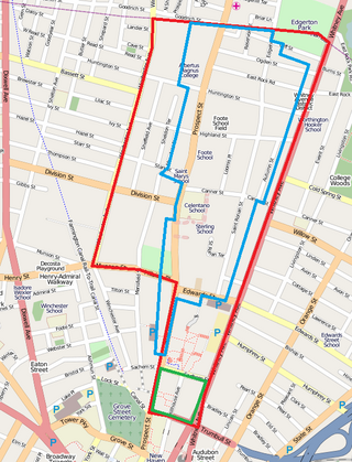
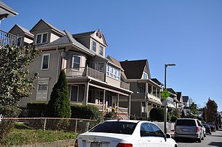
Prospect Hill is a neighborhood of the city of New Haven, Connecticut located in the north central portion of the city, directly north of Downtown New Haven. The neighborhood contains residences, institutional buildings of Albertus Magnus University and a portion of the main campus of Yale University, including the Science Hill area, the Hillhouse Avenue area and the Yale Peabody Museum. The City of New Haven defines the neighborhood to be the region bounded by the town of Hamden in the north, Winchester Avenue in the west, Munson Street/Hillside Place/Prospect Street in the southwest, Trumbull Street in the south, and Whitney Avenue in the east. Prospect Street is the main thoroughfare through the neighborhood.

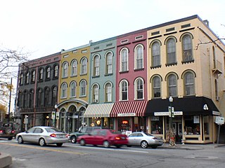
The Peabody Civic Center Historic District encompasses a well-preserved portion of the historic center of Peabody, Massachusetts. Extending along Chestnut and Franklin Streets south of Peabody City Hall, the district includes a small residential area built in the mid-19th century, as well as the city hall and St. JOhn the Baptist Roman Catholic Church, two monumental structures defining the town's civic heart. The district was added to the National Register of Historic Places in 1980.

The Joshua Hempsted House is a historic house museum at 11 Hempstead Street in New London, Connecticut. Built about 1678 and altered several times during the 18th century, it is one of the state's oldest surviving buildings, and provides a virtual catalog of early construction methods due to its state of preservation. The house was acquired by Connecticut Landmarks in 1937, which operates it and the adjacent 1759 Nathaniel Hempstead House as a historic house museum complex known as the Hempsted Houses. The houses have been restored to reflect a late 17th to mid 18th-century appearance, and was listed on the National Register of Historic Places in 1970.
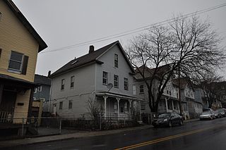
The Sterling Hill Historic District in Bridgeport, Connecticut is a historic district that was listed on the National Register of Historic Places in 1992. The district is a two-block area of 43 urban residential structures dating as far back as 1821. Most of the buildings are from later in the 19th century when the neighborhood was largely occupied by Irish working-class residents. Most of the early buildings are vernacular wood-frame structures with modest Federal, Greek Revival, or Gothic Revival details, while the later additions include multiunit tenement-style buildings. The area includes the oldest urbanized part of the city.

The Hillside Historic District in Waterbury, Connecticut is a 106-acre (43 ha) historic district that was listed on the National Register of Historic Places (NRHP) in 1987. It encompasses a residential area north of the city's central business district, and is bounded on the south by West Main Street, the west by Willow Avenue and Cliff and Frederick Streets, on the north by Buckingham Street and Woodland Terrace, and on the east by Cooke Street. Developed principally over an 80-year period between 1840 and 1920, it includes a cross-section of architectural styles of the 19th and early 20th centuries. The area was a desirable neighborhood of the city for much of this time, and was home to a number of the city's elite. In 1987, it included 395 buildings deemed to contribute to the historic character of the area, and one other contributing structure. It includes the Wilby High School and the Benedict-Miller House, which are both separately listed. 32 Hillside Road, a several acre property that includes the Benedict Miller House, was the original site of The University of Connecticut's Waterbury Branch until 2003.

The Williams Memorial Park Historic District is located in New London, Connecticut, roughly bounded by Hempstead, Broad, Mercer and Williams Streets, with houses on Broad Street south to Cottage Street included. Williams Memorial Park – which was designed by Frederick Law Olmsted – is also included, as is the Civil War monument located there; 16 houses are part of the district, while two buildings – a brick office building at 43 Broad Street and an apartment building at 127 Hempstead Street, are non-contributing properties. Four of the six outbuildings in the district are contributing. Nine different architectural styles are represented in the district.

The Post Hill Historic District encompasses the oldest settled area of New London, Connecticut.
The Montauk Avenue Historic District encompasses a residential area of New London, Connecticut that was a planned subdivision developed in the early 20th century as a "streetcar suburb". The district consists of 341 buildings and was added to the National Register of Historic Places on December 18, 1990. The district's main thoroughfares are Montauk Avenue and Ocean Avenue, which roughly define its western and eastern bounds, and it includes small cross streets between Willetts Avenue and Fair Harbour Place. Most of the district's houses were built after 1895, and are wood-frame structures in vernacular renditions of architectural revival styles popular in the early 20th century. Transitional forms between Queen Anne and other styles predominate. There are only four non-residential buildings in the district, all of which are masonry : two schools, a church, and a fire station.

The Nathaniel Hempstead House, also known as the Old Huguenot House, is a historic house museum on Hempstead Street in New London, Connecticut. Built about 1759, it is an architecturally unusual stone house with a gambrel roof, a style not otherwise seen in the city. Because of its unusual form, it was thought to have been built by French Huguenot immigrants at an earlier date. The house is owned by Connecticut Landmarks, along with the adjacent Joshua Hempsted House, operating the pair as the Hempstead Houses museum. The house was listed on the National Register of Historic Places on December 2, 1970.

The Orange Street Historic District encompasses a large residential in the East Rock section of New Haven, Connecticut. Roughly bounded by Orange, Cottage, Eagle, State, and Audubon Streets, this area saw growth between about 1830 and 1900, and includes a broad diversity of well-preserved 19th-century residential structures. It was listed on the U.S. National Register of Historic Places in 1985. At that time, it included 546 buildings deemed to contribute to the historic character of the area.

The Granby Center Historic District is a predominantly residential historic district encompassing a portion of the village of Granby Center in Granby, Connecticut. The village developed in the 18th century as a farming center, and a now includes a variety of architectural styles from the late 18th to early 20th centuries. The district was listed on the National Register of Historic Places (NRHP) in 1985.
The Ypsilanti Historic District is a historic district located along several blocks on each side of the Huron River in the center of Ypsilanti, Michigan. The original portion of the district was designated a Michigan State Historic Site in 1973 and listed on the National Register of Historic Places in 1978; additions to the district were nationally listed in 1989.

The Woodbury Historic District No. 2 encompasses a linear rural-residential area of southern Woodbury, Connecticut. It extends along the town's Main Street, from the town line with Southbury in the south to the South Pomperaug Avenue junction in the north. It contains some of the town's finest examples of 18th and early 19th-century residential architecture. It was listed on the National Register of Historic Places in 1972.

The Naubuc Avenue-Broad Street Historic District encompasses a largely agrarian village area of southwestern East Hartford, Connecticut. Extending along Naubuc Avenue from the Glastonbury line to Broad Street, and along Broad to Main Street, its architecture encapsulates the area's history between the 18th and early 20th centuries. It was listed on the National Register of Historic Places in 1998.

The Canoe Brook Historic District encompasses a small but ethnically diverse residential area west of the center of Branford, Connecticut, which exhibits more than 200 years of architectural history. It extends from Cherry Hill Road in the north to Bradley Street in the south, including portions of Main Street, Home Place, and North Harbor Street. It was listed on the National Register of Historic Places in 2002. The district takes its name from Canoe Brook, a waterway now largely built over by North Main Street and other construction.

The Naugatuck Center Historic District encompasses the historic civic and business center of Naugatuck, Connecticut. Centered around the town green, the district includes churches, schools and municipal buildings, many from the late 19th or early 20th centuries, as well as a diversity of residential architecture. The district was listed on the National Register of Historic Places in 1999.
The Esmond Street Historic District is a historic district encompassing a small residential area in the Dorchester neighborhood of Boston, Massachusetts. Centered on a stretch of Esmond Street, the area was developed between 1884 and 1928, and includes a fine sample of Colonial Revival and Queen Anne architecture. The district was listed on the National Register of Historic Places in 2018.

The Stuart Area Historic District is a primarily residential historic district Roughly bounded by the Michigan Central RR, Douglas, Forbes, West Main, North, and Elm Streets, and Kalamazoo and Grand Avenues, in Kalamazoo, Michigan. The bulk of the district was listed on the National Register of Historic Places in 1983, with additions in 1995.


