
Vilshofen an der Donau is a town in the German district of Passau.

Mantel is a municipality located in the district of Neustadt an der Waldnaab in Bavaria, Germany. It is known as a Markt, a town that was historically granted 'market rights'. The town was first mentioned in official documents in 1212, and in 1945 it was incorporated into the municipality of Rupprechtsreuth. As part of the regional reform in Bavaria, parts of the dissolved municipality of Hütten were added to it in 1972. The town's population fell by 77 people, 2.8%, to 2728 between 1988 and 2018. Mantel is best known for its nature preserve, Naturwaldreservat Gscheibte Loh, as well as its castle, Schloss Steinfels.

Laufen is a town on the southeastern border of Bavaria, Germany with Austria.

Roth is a town in Bavaria, Germany, the capital of the Roth District. It is located about 25 km south of Nuremberg.

Töging am Inn is a town of 9,382 inhabitants in the district of Altötting, Upper Bavaria, Germany. It lies on the Inn River.

Sulzbach-Rosenberg is a municipality in the Amberg-Sulzbach district, in Bavaria, Germany. It is situated approximately 14 km northwest of Amberg, and 50 km east of Nuremberg. The town consists of two parts: Sulzbach in the west, and Rosenberg in the east.

Wassertrüdingen is a town in the district of Ansbach, Middle Franconia, Bavaria, Germany. It is between the Hesselberg, the only Franconian mountain with a view on the Alps, the wooded heights of the Oettinger Forest and the foothills of the Hahnenkamm. The Fränkisches Seenland recreation area is 15 kilometers away. Altentrüdingen, Fürnheim, Geilsheim, Obermögersheim, Reichenbach und Schobdach are part of Wassertrüdingen

Lenggries is a municipality and a town in Bavaria, Germany. It is the center of the Isarwinkel, the region along the Isar between Bad Tölz and Wallgau. The town has about 9,500 inhabitants. By area, it is the largest rural municipality ("Gemeinde") in what was formerly West Germany, and the 7th-largest overall.

Colmberg is a municipality in the district of Ansbach in Bavaria in Germany. Colmberg is the site of Colmberg Castle, built in the 13th century and purchased in 1318 by Duke Frederick IV of Nuremberg. The town is located in Nature Park Frankenhöhe.

Bad Bocklet is a municipality in the district of Bad Kissingen in Bavaria in Germany. It is a market town and a health spa.

Kipfenberg is a municipality in the district of Eichstätt in Bavaria in Germany. It is known for its famous hillside castle and fortress, as well as being the geographical centre of Bavaria. The river Altmühl flows through the market town.

Walting is a municipality and a village in the district of Eichstätt in Bavaria, Germany.

Stockheim is a municipality in the district of Kronach in Bavaria in Germany. It is located on Bundesstraße 85, and on the touristic route Bier- und Burgenstraße.
Kreuth is a municipality in the district of Miesbach in Bavaria in Germany.

Kallmünz is a municipality in the district of Regensburg in Bavaria, Germany. Situated at the river Naab about 25 km north of Regensburg Kallmünz has conserved a beautiful medieval center. The main attractions are the ruins of the Kallmünz Castle above the town on a cliff and the old stone bridge over the Naab River. It was in Kallmünz that the Russian painter Wassily Kandinsky and the German expressionist painter Gabriele Münter met during the summer of 1903. Since then Kallmünz has been the constant home to a small art colony.
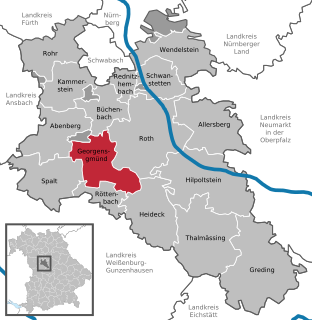
Georgensgmünd is a municipality in the district of Roth, in Bavaria, Germany.

Wernberg-Köblitz is a market town in the district of Schwandorf in Bavaria, Germany.
Bergrheinfeld is a municipality in the district of Schweinfurt in Bavaria, Germany.

Pfaffenhausen is a municipality in the district of Unterallgäu in Bavaria, Germany. The town is seat of a municipal association with Breitenbrunn, Swabia, Oberrieden, Bavaria and Salgen.

Neubeuern is a municipality in the district of Rosenheim in Bavaria in Germany. It lies on the inn river.


