
Pegnitz is a town in the Bayreuth district in Upper Franconia, Bavaria, Germany, with a population of approximately 15,000 inhabitants. It is also the source of the river Pegnitz. The city Bayreuth is about 27 km to the north.
Prichsenstadt is a town in the district of Kitzingen, Lower Franconia, Bavaria, Germany.
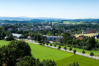
Münchberg is a small town in Upper Franconia (Bavaria), Germany. It is sometimes referred to as the Textile Town of Bavaria.

Heilsbronn is a town in the Ansbach district of the Mittelfranken administrative region of Franconia, in the German state of Bavaria between Nuremberg and Ansbach, in the wooded valley of the Rangau. Its hallmark is the Katharinenturm, a medieval tower.

Lichtenberg is a town in northeastern Bavaria, lying in the district of Hof in Upper Franconia.

Bad Rodach is a town in the district of Coburg, in Upper Franconia, a north Bavarian Regierungsbezirk, Germany. It is situated 10 km southeast of Hildburghausen, and 17 km northwest of Coburg. Since 1999 the city has been a spa-resort and is reported to have the warmest thermal spring in the North of Bavaria.
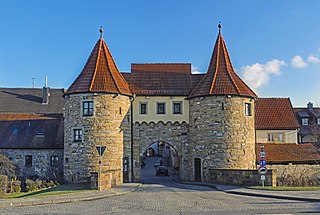
Hohenberg an der Eger is a town in the district of Wunsiedel, in Upper Franconia, Bavaria, Germany. It is situated on the river Eger, on the border with the Czech Republic, 11 km west of Cheb, and 14 km northeast of Marktredwitz. It was home to Hutschenreuther ceramic. Though best known for its ceramic production, Hohenberg has also produced some of Bavaria's elite soccer talent. Mauricio Göhlert played for the youth teams of SpVgg SV Weiden and Borussia Mönchengladbach before signing with SV Mitterteich in 2013.

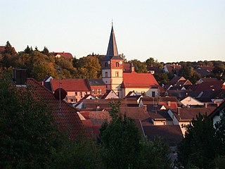
Königsberg in Bayern is a town in the Haßberge district, in Lower Franconia, Bavaria, Germany. It is situated 7 km northeast of Haßfurt, and 31 km northwest of Bamberg.

Merkendorf is a town and municipality in the district of Ansbach, in Bavaria, Germany. It is situated 14 km southeast of Ansbach.

Wassertrüdingen is a town in the district of Ansbach, Middle Franconia, Bavaria, Germany. It is between the Hesselberg, the only Franconian mountain with a view on the Alps, the wooded heights of the Oettinger Forest and the foothills of the Hahnenkamm. The Fränkisches Seenland recreation area is 15 kilometers away. Altentrüdingen, Fürnheim, Geilsheim, Obermögersheim, Reichenbach und Schobdach are part of Wassertrüdingen

Weißenstadt is a town in the district of Wunsiedel, in Upper Franconia, Bavaria, Germany. It is situated on the shore of the picturesque Weißenstadter See, in the Fichtelgebirge Mountains, on the river Eger, 11 km northwest of Wunsiedel. The town got its name "White City" from the landmark church, once white now weathered dark grey.

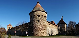
Lichtenau is a market town in the district of Ansbach, Middle Franconia, Bavaria, Germany. A small village/town of roughly 3,780 population on the “Castle Road” theme route of Southern Germany. It lies at 390 meters above sea level with an area of 41.39 km². A very traditional little town, it is also home to the “Veste Lichtenau” (castle) which now houses the Nuremberg Archives.

Bruckberg is a municipality in the district of Ansbach in Bavaria in Germany.

Colmberg is a municipality in the district of Ansbach in Bavaria in Germany. Colmberg is the site of Colmberg Castle, built in the 13th century and purchased in 1318 by Duke Frederick IV of Nuremberg. The town is located in Nature Park Frankenhöhe.

Ehingen is a municipality in the district of Ansbach in Bavaria in Germany.

Köditz is a municipality in Upper Franconia in the district of Hof in Bavaria in Germany.

Leupoldsgrün is a municipality in Upper Franconia. It can be found in the district of Hof, which is part of Bavaria, Germany.

Sparneck is a municipality in Upper Franconia in the district of Hof in Bavaria in Germany.
Kleinlangheim is a municipality in the district of Kitzingen in Lower Franconia, Bavaria in Germany.
Neubrunn is a municipality in the district of Würzburg in Lower Franconia, Bavaria, Germany.


