Lake Temagami, formerly spelled as Lake Timagami, is a lake in Nipissing District in northeastern Ontario, Canada, situated approximately 80 km north of North Bay. The lake's name comes from Te-mee-ay-gaming, which means "deep water by the shore" in the Ojibwa language.

Temagami, formerly spelled as Timagami, is a municipality in northeastern Ontario, Canada, in the Nipissing District with Lake Temagami at its heart.
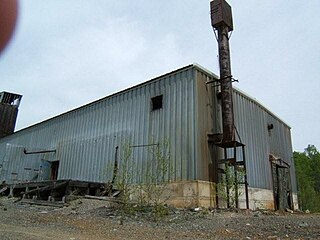
The Kanichee Mine, also less commonly known as the Ajax Mine, is an abandoned base metal and precious metal mine, located in the Temagami region of northeastern Ontario, Canada. It is near the small unincorporated community of Temagami North, accessed by the Kanichee Mine Road from Highway 11. The Kanichee Mine zone has been explored and mined discontinuously from as early as 1910. During the 20th century, it operated and closed down at least three times, with the most recent being from 1973 to 1976. To date, the discontinuous operation of Kanichee Mine has produced 4.2 million pounds of metal.

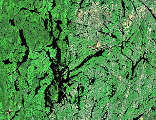
The Temagami Greenstone Belt (TGB) is a small 2.7 billion year old greenstone belt in the Temagami region of Northeastern Ontario, Canada. It represents a feature of the Superior craton, an ancient and stable part of the Earth's lithosphere that forms the core of the North American continent and Canadian Shield. The belt is composed of metamorphosed volcanic rocks that range in composition from basalt to rhyolite. These form the east-northeast trend of the belt and are overlain by metamorphosed sedimentary rocks. They were created during several volcanic episodes involving a variety of eruptive styles ranging from passive lava eruptions to viscous explosive eruptions.
Beanland Mine, also known as Clenor Mine, is an abandoned surface and underground mine in Northeastern Ontario, Canada. It is located about 1 km (0.62 mi) west of Arsenic Lake and 4 km (2.5 mi) northwest of the town of Temagami in central Strathy Township. It is named after Sydney Beanland, who first claimed the mine site in the 1920s and was a director for the mine from 1937 to 1938.

Barton Mine, also known as Net Lake Mine, is an abandoned surface and underground mine in Northeastern Ontario, Canada. It is located about 0.50 km (0.31 mi) north of the Temagami Arena in Temagami North and just east of the Ontario Northland Railway in northwestern Strathy Township. Dating back to the early 1900s, it is one of the oldest mines in Temagami. Barton was the site of a fire in the early 1900s, after which it never had active mining again.

Big Dan Mine is an abandoned underground mine in Northeastern Ontario, Canada. It is located about 1 km (0.62 mi) southwest of Net Lake and just west of the Ontario Northland Railway in east-central Strathy Township. It is named after Dan O'Connor, who first claimed the site in the 1890s.
Strathy Township is a square-shaped geographic township comprising a portion of the municipality of Temagami in Northeastern Ontario, Canada. It is used for geographic purposes, such as land surveying and natural resource explorations. At least four other geographic townships surround Strathy Township, namely Best Township, Cassels Township, Strathcona Township and Chambers Township.
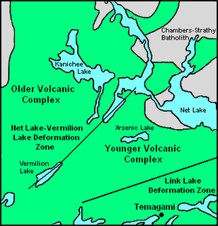
The Link Lake Deformation Zone, also known as the Link Lake Zone of Deformation and the Link Lake Shear Zone, is a zone of deformation in Strathy Township of Temagami, Ontario, Canada. It is at least 0.5 km (0.31 mi) wide and over 3 km (1.9 mi) long, extending from Link Lake in the west to east of Highway 11.
The Northeast Arm Deformation Zone, also known as the Northeast Arm Zone of Deformation, is a zone of deformation in Strathcona Township of Temagami, Ontario, Canada. It extends along the northeast arm of Lake Temagami. The Link Lake Deformation Zone just to the north is interpreted to be an extension of the Northeast Arm Deformation Zone.
The Tasse Lake Deformation Zone is a zone of deformation in Temagami, Ontario, Canada, extending from the western boundary of Chambers Township through Tasse Lake in the east. Its structure is at least 0.5 km (0.31 mi) wide and 3 km (1.9 mi) long, although it remains uncertain if it extends east of Tasse Lake.
The Net Lake-Vermilion Lake Deformation Zone, also known as the Net Lake-Vermilion Lake Zone of Deformation, is a zone of deformation in Temagami, Ontario, Canada, extending from Vermilion Lake to Net Lake in a northeasterly direction.

Johnny Creek is one of many creeks running through the Temagami region of Northeastern Ontario, Canada. It is located about 4 km (2.5 mi) south of Temagami North in southeastern Strathy Township. The creek is entirely within the municipality of Temagami, flowing in a west–east direction.
Temagami-Lorrain Mine is an abandoned surface and underground mine in Northeastern Ontario, Canada. It is located about 10 km (6.2 mi) northeast of the town of Temagami near Sauvé Lake in central Cassels Township. It is named after the Temagami-Lorrain Mining Company, which carried out work on the property in the early 1900s.
Priest Mine is an abandoned surface and underground mine in Northeastern Ontario, Canada. It is located about 19 km (12 mi) northwest of the hamlet of Marten River on an island in north-central Cross Lake. Dating back to the early 1900s, it is one of the oldest mines in the municipality of Temagami.
The Temagami Occurrence is a geological occurrence in Northeastern Ontario, Canada. It is located near the southern end of Kanichee Lake in west-central Strathy Township. It is named after Temagami, the municipality in which the occurrence is located in.
The Danlou Occurrence, also known as the Danlou Gold Occurrence and the Mortimer Occurrence, is a mineralized zone in Northeastern Ontario, Canada. Gold is the occurrence's primary commodity while copper and silver are secondary commodities. It occurs in a quartz vein within a diabase-porphyry shear zone. Pyrite and chalcopyrite are present in small amounts.

The Quinchía mine is a gold mine in Colombia. The mine is located in Quinchía, Risaralda. The mine has estimated reserves of 390,000 ounces (11 t) of gold and 817,000 ounces (23.2 t) of silver. In 2016, Quinchía produced 73,475.73 kilograms (2,591,780 oz) of gold, and 10,587.99 kilograms (373,480 oz) of silver.

The Northeast Arm Iron Range, also called the Temagami Iron Range, is an elongated area of iron ore in Nipissing District of Northeastern Ontario, Canada. It parallels the western side of Lake Temagami's Northeast Arm near the village of Temagami at its northern end. One of many small iron ranges in the Temagami area, the Northeast Arm Range consists of alternating bands of iron-rich and iron-poor sediments. It was discovered in the 1890s and has since seen sporadic mining and mineral exploration activities.

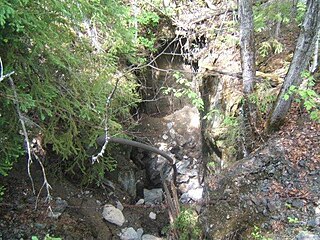
Vermilion Lake, sometimes incorrectly spelled Vermillion Lake, was a natural lake located 5 km (3.1 mi) northwest of the village of Temagami in Nipissing District, Ontario, Canada. It occupied the southwestern corner of geographic Strathy Township until it was dewatered in 1967 to provide initial tailings storage for the then developing Sherman Mine.
