Hermosa, Colorado

Last updated

Hermosa
Unincorporated community
Hermosa, Colorado.JPG
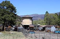
The D&SNG water tank along U.S. Route 550 in Hermosa, April 2020
Etymology: From the Spanish word hermosa, meaning beautiful [1]
USA Colorado location map.svg
Red pog.svg
Hermosa
Location within the state of Colorado
Coordinates: 37°24′55″N107°50′07″W / 37.41528°N 107.83528°W / 37.41528; -107.83528 [2]
CountryFlag of the United States (23px).png  United States
State Flag of Colorado.svg  State of Colorado
County La Plata County
Elevation
[2]
6,644 ft (2,025 m)
Time zone UTC-7 (MST)
  Summer (DST) UTC-6 (MDT)
ZIP code
81301
Area code 970
GNIS feature ID183933 [2]

Hermosa is an unincorporated community in La Plata County, Colorado, United States. It is located north of Durango along U.S. Highway 550. [1]

Contents

History

The community was established around 1874 [1] and had a post office from 1876 to 1900. [3] Residents are now served by post offices in Durango.

In 2018, the 416 Fire burned northwest of Hermosa, prompting evacuations.

Attractions

The Durango and Silverton Narrow Gauge Railroad has a water stop in Hermosa, and the railroad maintains a maintenance yard and a siding there, which is sometimes called the Hermosa Depot. The yard has a prominent railroad water tank that is easily seen by motorists passing through Hermosa on Highway 550.

Hermosa Creek passes through the community from west to east and has its confluence with the Animas River nearby.

The Hermosa Cliffs, [4] formed of red sandstone, line the river valley in Hermosa.

See also

Related Research Articles

<span class="mw-page-title-main">Rico, Colorado</span> Town in Colorado, United States

Rico is a town in Dolores County, Colorado, United States. It was settled in 1879 as a silver mining center in the Pioneer Mining District; today it functions as a historic and tourism site. The population was 288 at the 2020 census. Its current form of government is that of a home rule municipality.

<span class="mw-page-title-main">Durango, Colorado</span> City in Colorado, United States

Durango is a home rule municipality that is the county seat and the most populous municipality of La Plata County, Colorado, United States. The city population was 19,071 at the 2020 United States Census. Durango is the home of Fort Lewis College.

<span class="mw-page-title-main">Clifton, Colorado</span> Census-designated place in Mesa County, Colorado, United States

Clifton is a census-designated place (CDP) and post office in and governed by Mesa County, Colorado, United States. It is part of the Grand Junction, CO Metropolitan Statistical Area. The Clifton post office has the ZIP Code 81520. As of the 2020 census, the population of the Clifton CDP was 20,413.

<span class="mw-page-title-main">Mount Forest Township, Michigan</span> Civil township in Michigan, United States

Mount Forest Township is a civil township of Bay County in the U.S. state of Michigan. The township's population was 1,399 as of the 2020 census. It is included in the Bay City Metropolitan Statistical Area.

<span class="mw-page-title-main">Farmington, New Mexico</span> City in New Mexico, United States

Farmington is a city in San Juan County in the U.S. state of New Mexico. As of the 2020 census, the city had a population of 46,624 people. Farmington makes up one of the four metropolitan statistical areas (MSAs) in New Mexico.

<span class="mw-page-title-main">Little Colorado River</span> River in Arizona, United States

The Little Colorado River is a tributary of the Colorado River in the U.S. state of Arizona, providing the principal drainage from the Painted Desert region. Together with its major tributary, the Puerco River, it drains an area of about 26,500 square miles (69,000 km2) in eastern Arizona and western New Mexico. Although it stretches almost 340 miles (550 km), only the headwaters and the lowermost reaches flow year-round. Between St. Johns and Cameron, most of the river is a wide, braided wash, only containing water after heavy snowmelt or flash flooding.

<span class="mw-page-title-main">U.S. Route 550</span> Highway in the United States

U.S. Route 550 (US 550) is a spur of U.S. Highway 50 that runs from Bernalillo, New Mexico to Montrose, Colorado in the western United States. The section from Silverton to Ouray is frequently called the Million Dollar Highway. It is one of the roads on the Trails of the Ancients Byway, one of the designated New Mexico Scenic Byways.

<span class="mw-page-title-main">Dotsero, Colorado</span> Census Designated Place in Colorado, United States

Dotsero is an unincorporated community and a census-designated place (CDP) located in and governed by Eagle County, Colorado, United States. The CDP is a part of the Edwards, CO Micropolitan Statistical Area. The population of the Dotsero CDP was 1,172 at the United States Census 2020. The Gypsum post office serves the area.

<span class="mw-page-title-main">Red Mountain Pass (San Juan Mountains)</span> Mountain pass in the state of Colorado

Red Mountain Pass elevation 11,018 ft (3,358 m) is a mountain pass in the San Juan Mountains of western Colorado in the United States.

<span class="mw-page-title-main">San Juan Skyway Scenic and Historic Byway</span> Colorado Scenic and Historic Byway

The San Juan Skyway Scenic and Historic Byway is a 236-mile (380 km) All-American Road, National Forest Scenic Byway, and Colorado Scenic and Historic Byway located in Dolores, La Plata, Montezuma, San Juan, and San Miguel counties, Colorado, United States. The byway forms a loop in southwestern Colorado traversing the heart of the San Juan Mountains. The San Juan Skyway reaches its zenith at Red Mountain Pass at elevation 11,018 feet (3,358 m). Mesa Verde National Park was one of the original UNESCO World Heritage Sites. The Silverton Historic District and the Telluride Historic District are National Historic Landmarks.

<span class="mw-page-title-main">Chivington, Colorado</span> Unincorporated community in Kiowa County, Colorado, United States

Chivington is an unincorporated community in Kiowa County, Colorado, United States. The Chivington post office operated from October 24, 1887, until January 1, 1991. The U.S. Post Office at Eads now serves Chivington postal addresses.

Mumford is an unincorporated community in Robertson County, Texas, United States. It is part of the Bryan-College Station metropolitan area. Its elevation is 259 feet (79 m), and it is located at 30°44′4″N96°33′54″W. Mumford is unincorporated and has no post office, with the ZIP code of 77867; the ZCTA for ZIP Code 77867 had a population of 176 at the 2000 census.

<span class="mw-page-title-main">Cumbres Pass</span> Mountain pass in Colorado, U.S.

Cumbres Pass, elevation 10,022 ft (3,055 m), is a mountain pass in the San Juan Mountains in Colorado, United States. The pass is traversed by State Highway 17 and the Cumbres and Toltec Scenic Railroad. The highway has a moderate 5.8% approach on the north side and a gentler, 4% approach on the south side. It is rarely closed in winter and does not normally cause problems for vehicles, since the road is not a major through highway.

<span class="mw-page-title-main">Wolcott, Colorado</span> Census Designated Place in Colorado, United States

Wolcott is an unincorporated town, a post office, and a census-designated place (CDP) located in and governed by Eagle County, Colorado, United States. The CDP is a part of the Edwards, CO Micropolitan Statistical Area. The Wolcott post office has the ZIP Code 81655. At the United States Census 2020, the population of the Wolcott CDP was 20.

<span class="mw-page-title-main">416 Fire</span>

The 416 and Burro Fire Complex were two wildfires that burned in the southwestern portion of Colorado in the United States in 2018. The fires burned predominantly within San Juan National Forest, 13 miles north of Durango and 14 miles south of Rico. The 416 Fire started on June 1, 2018, and the Burro Fire followed on June 8. Federal officials allege that embers emitted from a coal-burning steam locomotive used by the historic Durango and Silverton Narrow Gauge Railroad started the blaze, and have filed a lawsuit against the railroad seeking recoupment of $25 million in firefighting costs, penalties and legal expenses. The fires burned a combined total of over 57,000 acres (23,067 ha) and have cost more than $43 million to contain. On March 31, 2022, the Durango and Silverton Narrow Gauge Railroad reached settlements in two lawsuits stemming from its role in starting the 416 fire: one settlement with federal authorities in which the railroad would pay $20 million to the federal government and institute a fire mitigation program for its operations. In the second settlement, the railroad agreed to pay an undisclosed amount to home and business owners impacted by the fire and subsequent floods during the summer monsoon season that followed in the wake of the 416 fire.

<span class="mw-page-title-main">Hermosa Creek</span> River in Colorado, United States

Hermosa Creek is a tributary of the Animas River in San Juan and La Plata counties in Colorado. The creek rises near Hermosa Peak in San Juan County, Colorado and then flows generally south to La Plata County and to its confluence with the Animas River in Hermosa.

<span class="mw-page-title-main">Guston, Colorado</span> Ghost town in Ouray County, Colorado, United States

Guston is a silver mining ghost town in Ouray County, Colorado, United States, 11 miles (18 km) south of Ouray following the "Million Dollar Highway". Nestled in Champion Gulch, it is located near Red Mountain and the remnants of Red Mountain Town and Ironton. The Silverton Railroad ran from Guston in the Red Mountain Pass to Silverton in San Juan County. The silver mining camp was established in 1883. The Guston post office operated from January 26, 1892, until November 16, 1898.

<span class="mw-page-title-main">Mount Garfield (San Juan County, Colorado)</span> Mountain in the American state of Colorado

Mount Garfield is a 13,074-foot-elevation (3,985-meter) mountain summit located in San Juan County, Colorado, United States. It is situated eight miles south of the community of Silverton, in the Weminuche Wilderness, on land managed by San Juan National Forest. It is part of the San Juan Mountains range which is a subset of the Rocky Mountains of North America. Precipitation runoff from the mountain drains into tributaries of the Animas River. The peak can be seen from U.S. Route 550 and the Durango and Silverton Narrow Gauge Railroad. Topographic relief is significant as the west aspect rises over 4,300 feet above the river and railway in approximately one mile. It is set six miles west of the Continental Divide, one mile west of Electric Peak, and three miles east-southeast of Snowdon Peak.

<span class="mw-page-title-main">Electric Peak (San Juan Mountains)</span> Mountain in Colorado

Electric Peak is a 13,292-foot-elevation (4,051-meter) mountain summit located in San Juan County, Colorado, United States. It is situated eight miles south of the community of Silverton, in the Weminuche Wilderness, on land managed by San Juan National Forest. It is part of the Needle Mountains which are a subset of the San Juan Mountains, which in turn is a subset of the Rocky Mountains. Precipitation runoff from the mountain drains into tributaries of the Animas River. The peak can be seen from U.S. Route 550 and the Durango and Silverton Narrow Gauge Railroad. Topographic relief is significant as the west aspect rises over 4,500 feet above the river and railway in approximately two miles. It is set five miles west of the Continental Divide, and one mile east of Mount Garfield. The mountain's name, which has been officially adopted by the United States Board on Geographic Names, was in use before 1906 when Henry Gannett published it in the Gazetteer of Colorado.

Center Point is an unincorporated community and census-designated place (CDP) in San Juan County, New Mexico, United States. It was first listed as a CDP prior to the 2020 census.

References

  1. 1 2 3 Bright, William (2004). Colorado place names (Third ed.). Boulder: Johnson Books. p. 85. ISBN   1555663338. LCCN   2003024331.
  2. 1 2 3 U.S. Geological Survey Geographic Names Information System: Hermosa, Colorado
  3. "Post offices". Jim Forte Postal History. Retrieved May 4, 2020.
  4. "Hermosa Cliffs". Geographic Names Information System . United States Geological Survey, United States Department of the Interior . Retrieved May 4, 2020.

Commons-logo.svg Media related to Hermosa, Colorado at Wikimedia Commons