
Pennington County is a county in the northwestern part of the U.S. state of Minnesota. As of the 2020 census, the population was 13,992. Its county seat is Thief River Falls.

Thief River Falls, sometimes referred to as Thief River or abbreviated as TRF, is a city in, and the county seat of, Pennington County in the northwest portion of the U.S. state of Minnesota. The population was 8,749 at the 2020 census.
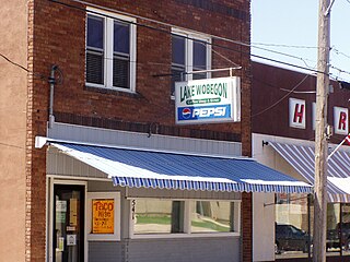
Holdingford is a city in Stearns County, Minnesota, United States. The population was 708 at the 2010 census. It claims to be "The Gateway to Lake Wobegon", the fictional central Minnesota town created by author Garrison Keillor.

Pennington Gap is a town in Lee County, Virginia, United States. The population was 1,624 at the 2020 census.
Bowstring is an unincorporated community in Bowstring Township, Itasca County, Minnesota, United States.

Head Waters is an unincorporated community in Highland County, Virginia, United States. Head Waters is located approximately 4.25 miles (6.84 km) east of McDowell on US 250. The South Fork South Branch Potomac River rises north of Head Waters, hence the community's name. Head Waters has a post office with ZIP code 24442.
Landing is an unincorporated community and census-designated place (CDP) located within Roxbury Township, in Morris County, in the U.S. state of New Jersey. The community is located on the south shore of Lake Hopatcong near Hopatcong State Park. The area is served as United States Postal Service ZIP Code 07850.
Kelsey is an unincorporated community in Kelsey Township, Saint Louis County, Minnesota, United States.
Burnett is an unincorporated community in Industrial Township, Saint Louis County, Minnesota, United States.
Angora is an unincorporated community in Angora Township, Saint Louis County, Minnesota, United States.
Hazel is an unincorporated community in Pennington County, Minnesota, United States, along the Canadian Pacific Railway. The community is only marked on county abstracts and has no postal code. Hazel is the location of a Cenex Harvest States shipping facility.

Erie is a small unincorporated community in Pennington County, Minnesota, United States. The community had local businesses until the late 20th century with the closing of its last store, Sjulstad Store.
Kratka was a community in rural Pennington County, Minnesota, United States.
Radium is an unincorporated community in section 19 of Comstock Township, Marshall County, Minnesota, United States. It was built alongside the Minneapolis, St. Paul and Sault Ste. Marie Railroad branch line built in 1905 from Thief River Falls, Minnesota, to Kenmare, North Dakota. The place was named for the element radium. Radium had its own post office from 1905 to 1984. Since 1984, Radium has been served by the post office in Warren. It is also on the Warren telephone exchange and part of the Warren-Alvarado-Oslo school district. The townsite is being slowly reclaimed for use as farmland. There is still a large grain elevator on the railroad line south of the townsite. A small Lutheran church 1+1⁄2 miles (2.4 km) south of the town antedates the coming of the railroad; Immanuel Lutheran Church (LCMS) was organized in 1897.

Maple Springs is an unincorporated community in Pepin Township, Wabasha County, Minnesota, United States, along the Mississippi River and Lake Pepin. The Mississippi River and King Creek meet at Maple Springs.
Gatzke is an unincorporated community in Rollis Township, Marshall County, Minnesota, United States.
Pennington, also called Cass River, is an unincorporated community in Beltrami County, Minnesota, United States. Pennington is 9.5 miles (15.3 km) northeast of Cass Lake. Pennington has a post office with ZIP code 56663.
Wawina is an unincorporated community in Wawina Township, Itasca County, Minnesota, United States.
Wilton is an unincorporated community in Wilton Township, Waseca County, Minnesota, United States, near Waseca. The community is located near the junction of Waseca County Roads 4 and 23. The Le Sueur River flows through the community.
Mildred is an unincorporated community in Pine River Township, Cass County, Minnesota, United States, near Pine River and Backus.


