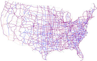
The United States Numbered Highway System is an integrated network of roads and highways numbered within a nationwide grid in the contiguous United States. As the designation and numbering of these highways were coordinated among the states, they are sometimes called Federal Highways, but the roadways were built and have always been maintained by state or local governments since their initial designation in 1926.
Interstate 26 (I-26) is a main route of the Interstate Highway System in the Southeastern United States. Nominally east–west, as indicated by its even number, I-26 runs from the junction of US Route 11W (US 11W) and US 23 in Kingsport, Tennessee, generally southeastward to US 17 in Charleston, South Carolina. The portion from Mars Hill, North Carolina, east to I-240 in Asheville, North Carolina, has signs indicating FUTURE I-26, because the highway does not yet meet all of the Interstate Highway standards.

Interstate 29 (I-29) is an Interstate Highway in the Midwestern United States. I-29 runs from Kansas City, Missouri, at a junction with I-35 and I-70, to the Canada–US border near Pembina, North Dakota, where it connects with Manitoba Provincial Trunk Highway 75 (PTH 75), which continues on to Winnipeg. The road follows the course of three major rivers, all of which form the borders of US states. The southern portion of I-29 closely parallels the Missouri River from Kansas City northward to Sioux City, Iowa, where it crosses and then parallels the Big Sioux River. For the northern third of the highway, it closely follows the Red River of the North. The major cities that I-29 connects to includes Council Bluffs, Iowa; Sioux City, Iowa; Sioux Falls, South Dakota; Fargo, North Dakota; and Grand Forks, North Dakota. I-29 also serves as a road connection between the four largest public universities in the Dakotas: the University of North Dakota, North Dakota State University, the University of South Dakota, and South Dakota State University.

U.S. Route 412 is an east–west United States highway, first commissioned in 1982. U.S. 412 overlaps expressway-grade Cimarron Turnpike from Tulsa west to Interstate 35 and the Cherokee Turnpike from 5 miles (8.0 km) east of Chouteau, Oklahoma, to 8 miles (13 km) west of the Arkansas state line. It runs the entire length of the Oklahoma Panhandle and traverses the Missouri Bootheel.

U.S. Route 75 is a north–south U.S. Highway that runs 1,239 miles (1,994 km) in the central United States. The highway's northern terminus is located at the Canadian border near Noyes, Minnesota, at a now-closed border crossing. From this point, the highway once continued farther north as Manitoba Highway 75. Its southern terminus is located at Interstate 30 (I-30) and I-45 in Dallas, Texas, where US 75 is known as North Central Expressway.

U.S. Route 5 (US 5) is a north–south United States Numbered Highway running through the New England states of Connecticut, Massachusetts, and Vermont. Significant cities along the route include New Haven, Connecticut; Hartford, Connecticut; and Springfield, Massachusetts. From Hartford northward to St. Johnsbury, Vermont, the road closely follows the route of the Connecticut River.
U.S. Route 84 (US 84) is an east–west United States Numbered Highway that started as a short Georgia–Alabama route in the original 1926 scheme. Later, in 1941, it had been extended all the way to Colorado. The highway's eastern terminus is a short distance east of Midway, Georgia, at an Interchange with I-95. The road continues toward the nearby Atlantic Ocean as a county road. Its northern terminus is in Pagosa Springs, Colorado, at an intersection with US 160.

U.S. Route 24 or U.S. Highway 24 (US 24) is one of the original United States Numbered Highways of 1926 which runs east and west for most of its routing. It originally ran from Pontiac, Michigan, in the east to Kansas City, Missouri, in the west. Today, the highway's eastern terminus is in Independence Township, Michigan, at an intersection with Interstate 75 (I-75), and its western terminus is near Minturn, Colorado, at an intersection with I-70. The highway transitions from north–south to east–west signage at the Ohio–Michigan state line.
U.S. Route 29 or U.S. Highway 29 (US 29) is a north–south United States Numbered Highway that runs for 1,043.3 miles (1,679.0 km) from Pensacola, Florida, to Ellicott City, Maryland, just west of Baltimore, Maryland, in the Eastern United States, connecting the Florida Panhandle to the Washington–Baltimore combined statistical area. The highway takes on an overall northeast–southwest direction, from its southern terminus at US 90 and US 98 in Pensacola to its northern terminus at Maryland Route 99 (MD 99) in Ellicott City.

U.S. Route 136 is an east-west U.S. highway that is a spur route of U.S. Route 36. It runs from Edison, Nebraska, at U.S. Route 6 and U.S. Route 34 to the Interstate 74/Interstate 465 interchange in Speedway, Indiana. This is a distance of 804 miles (1,294 km). Due to the removal of almost every numbered route in Indianapolis, US 136 never meets its parent, US 36; however, it does come within two miles of it at its interchange with I-465/I-74 at its eastern terminus.
U.S. Route 191 is a north–south highway in the Western United States and a spur of parent route U.S. Route 91 that has two segments. The southern segment runs for 1,102 miles (1,773 km) from Douglas, Arizona on the Mexican border to the southern part of Yellowstone National Park. The northern segment runs for 442 miles (711 km) from the northern part of Yellowstone National Park to Loring, Montana, at the Canada–US border. Unnumbered roads within Yellowstone National Park connect the two segments. The highway passes through the states of Arizona, Utah, Wyoming, and Montana.
U.S. Route 78 (US 78) is an east–west United States Numbered Highway that runs for 843.3 miles (1,357.2 km) from Cash, Arkansas, to Charleston, South Carolina. From Byhalia, Mississippi to Birmingham, Alabama, US 78 runs concurrently with Interstate 22 (I-22). The highway’s western terminus is at US 67 /Arkansas Highway 226 (AR 226) near Cash, and its eastern terminus is on Line Street, in Charleston. Prior to November 2023, before the western extension, the highway's former western terminus was at US 64/US 70/US 79 in Memphis, Tennessee.

North Carolina Highway 97 (NC 97) is a primary state highway in the U.S. state of North Carolina, connecting the cities of Zebulon and Rocky Mount with the vast rural coastal plains.
The primary highways of Peru are assigned using a numeric designation and sometimes a name. Spur and loop routes are designated with the parent highway's number and a letter.

U.S. Route 281 (US 281) is a United States Numbered Highway that runs from the Mexican border in the Rio Grande Valley to the Canadian border near Dunseith, North Dakota. In the state of Texas, the highway is a major south–north corridor, connecting Brownsville to the Oklahoma state line at the Red River in Burkburnett. Several segments of U.S. 281 are concurrent with Interstate routes, including I-69C in the Rio Grande Valley, I-37 in San Antonio, and I-44 north of Wichita Falls.

In Tennessee, U.S. Route 64 stretches 404.1 miles (650.3 km) from the Mississippi River in Memphis to the North Carolina state line near Ducktown. The highway, along with US 72, is a major route for travel between Memphis and Chattanooga.
Interstate 87 (I-87) is a partially completed Interstate Highway in the US state of North Carolina, the shortest designated primary Interstate Highway at 12.90 miles (20.76 km) long. The completed portion is in eastern Wake County, between Raleigh and Wendell; the majority of the completed route is known as the Knightdale Bypass, while the remaining three miles (4.8 km) follows the Raleigh Beltline (I-440). It is planned to continue northeast through Rocky Mount, Williamston, and Elizabeth City, ending in Norfolk, Virginia. It is signed as north–south, in keeping with the sign convention for most odd-numbered interstates, but the route goes primarily east–west, with the eastern direction aligning to the north designation. The entire route is concurrent with US Highway 64 (US 64), with portions also concurrent with I-440 and US 264.


