
The City of Chelmsford is a local government district with borough and city status in Essex, England. It is named after its main settlement, Chelmsford, which is also the county town of Essex. As well as the settlement of Chelmsford itself, the district also includes the surrounding rural area and the town of South Woodham Ferrers.
Chignal Smealy is a small village and former civil parish, now in the parish of Chignall, on the north-western outskirts of Chelmsford, in the Chelmsford district, in the county of Essex, England. The local church is a red brick building, containing an unusual red brick baptismal font which has been used for many christenings. In 1881 the parish had a population of 134. On 24 March 1888 the parish was abolished to form Chignall.

Ingatestone is a village and former civil parish in Essex, England, with a population of 5,409 inhabitants according to the 2021 census. Just north lies the village of Fryerning, the two now forming the parish of Ingatestone and Fryerning, in the Borough of Brentwood. Ingatestone lies in the Metropolitan Green Belt 20 miles north-east of London. Its built-up area straddles the A12 trunk road and the Great Eastern Main Railway Line. It has become an affluent commuter village, seen as one of the UK's best places to live by the Sunday Times in 2020.

Felsted is a village and civil parish in the Uttlesford district of Essex, England. The civil parish includes the hamlets of Bannister Green, Bartholomew Green, Causeway End, Coblers Green, Cock Green, Frenches Green, Gransmore Green, Hartford End, Molehill Green, Milch Hill, Thistley Green, Watch House Green and Willows Green.

Saffron Walden is a constituency in Essex, represented in the House of Commons of the UK Parliament since 2017 by Kemi Badenoch, a Conservative.

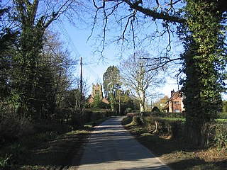
Mashbury is a small village and civil parish in the Chelmsford district of Essex, England. The population of the village is included in the civil parish of Pleshey.
Ilford was a civil parish and local government district in south west Essex, England from 1888 to 1965, covering the town Ilford. The district saw a considerable rise in population throughout its life, caused by the expansion of the built-up area of London, and became one of the most populous districts of its type in England. The district now corresponds to the greater part of the London Borough of Redbridge in Greater London.

The Rodings are a group of eight villages in the upper part of the River Roding and the west of Essex, England, the largest group in the country to bear a common name. The Rodings do not lie within a single district in the county; they are arranged around the tripoint of the administrative areas of Chelmsford, Uttlesford and Epping Forest. An alternative arcane name, linked to the Middle English Essex dialect, was The Roothings.

Asheldham is a village and civil parish in Essex, England. It is located about 14 km (8.7 mi) southeast of Maldon and is 26 km (16 mi) east-southeast from the county town of Chelmsford. The village is in the district of Maldon and the parliamentary constituency of Maldon & East Chelmsford. The village is part of the combined Asheldham and Dengie Parish Council.

Chelmsford is a constituency in Essex represented in the House of Commons of the UK Parliament since 2017 by Vicky Ford of the Conservative Party.

The Diocese of Chelmsford is a Church of England diocese, part of the Province of Canterbury. It was created on 23 January 1914 from part of the Diocese of St Albans. It covers Essex and part of East London. Since 1984 it is divided into three episcopal areas, each with its own area bishop. The diocese covers around 1,500 square miles (3,900 km2) with a population of more than 3 million. It has 463 parishes and 588 churches.

Hadham Rural District was a rural district in Hertfordshire, England from 1894 to 1935, covering an area in the east of the county.

Downham is a small village and former civil parish, now in the parish of South Hanningfield, in the City of Chelmsford district, Essex, England. It is located approximately 7 miles (11 km) south of the county town of Chelmsford. The village is in the parliamentary constituency of Rayleigh; however, the closest two towns are Billericay, 3+1⁄2 miles (5.6 km) west-south-west, and Wickford, 2+1⁄4 miles (3.6 km) south-east. In 1931, the parish had a population of 833.

Hunsdon is a village and civil parish in Hertfordshire, England. It is around 5.5 miles (9 km) east of Ware and 5 miles (8 km) north-west of Harlow. The population of the village taken at the 2011 Census was 1,080.
Chelmsford Rural District was a local government district in Essex, England from 1894 to 1974. It surrounded, but did not include, the town of Chelmsford; which formed a municipal borough.

Springfield is a civil parish of the Borough of Chelmsford in Essex, England, which is now a north-eastern suburb of the city of Chelmsford.

Chignall St James is a village and former civil parish, now in the parish of Chignall, in the Chelmsford district in Essex, England. The village is situated 3½ miles northwest by west from the county town of Chelmsford. In 1881 the parish had a population of 224. On 24 March 1888 the parish was abolished to form Chignall, parts also went to Broomfield and Writtle.
Margaretting is a village and civil parish in the Chelmsford district, in the county of Essex, England. The population of the village taken at the 2011 Census was 847.

Roxwell is a village and civil parish in the Chelmsford district of Essex, England. The village is approximately 4 miles (6 km) west from the centre of the county town of Chelmsford, and to the south of the A1060 road, on which are the parish hamlets of Boyton Cross and Chalk End. Further Roxwell hamlets are Peppers Green at the north of the parish and Radley Green at the south.

Cooksmill Green is a hamlet in both the civil parish of Roxwell and Highwood in the Chelmsford District of Essex, England. It is situated approximately 4 miles (6 km) west from the centre of the county town of Chelmsford. The A414 road is less than one mile to the south.
