| Chignal Smealy | |
|---|---|
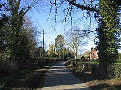 Village of Chignall Smealy | |
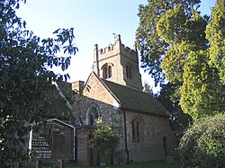 The church of St Nicholas | |
 Chignal Smealy Location within Essex | |
| OS grid reference | TL663113 |
| Civil parish | |
| District | |
| Shire county | |
| Region | |
| Country | England |
| Sovereign state | United Kingdom |
| Post town | CHELMSFORD |
| Postcode district | CM1 |
| Dialling code | 01245 |
| Police | Essex |
| Fire | Essex |
| Ambulance | East of England |
Chignal Smealy is a small village and former civil parish, now in the parish of Chignall, on the north-western outskirts of Chelmsford, in the Chelmsford district, in the county of Essex, England. The local church (St. Nicholas) is a red brick building, containing an unusual red brick baptismal font which has been used for many christenings. In 1881 the parish had a population of 134. [1] On 24 March 1888 the parish was abolished to form Chignall. [2]
Contents
The village was struck by an F1/T2 tornado on 23 November 1981, as part of the record-breaking nationwide tornado outbreak on that day. [3]
The spelling of the village name is open to discussion. Sometimes it is spelt "Chignall Smealy" other times, it is spelt "Chignal Smealy".