Galleywood | |
---|---|
The Eagle, Galleywood (2020) | |
Location within Essex | |
Population | 5,700 (2021) [1] |
OS grid reference | TL705028 |
• London | 29.04 mi (46.74 km) |
Civil parish |
|
Unitary authority | |
Shire county | |
Ceremonial county |
|
Region | |
Country | England |
Sovereign state | United Kingdom |
Post town | CHELMSFORD |
Postcode district | CM2 |
Dialling code | 01245 |
Police | Essex |
Fire | Essex |
Ambulance | East of England |
UK Parliament | |
Galleywood is a village surrounded by countryside in Essex; it is situated on the outskirts of the city of Chelmsford, about 30 miles from London. The A12 trunk road passes nearby, which connects to the M25 in London. Galleywood sits astride a Roman road running south from Chelmsford towards Vange Creek; currently, the B1007 Stock Road and B1009 Beehive Lane run through it. Galleywood was a part of the Great Baddow parish, comprising two villages or hamlets: Galleywood and Galleyend, about a mile apart. Galleywood has a population of 5,700 [1] and has a higher percentage of retired citizens than the national average. Galleywood Common is approximately 400 yards in width and one mile in length, consisting of open fields and woodland. It also has St. Michael's Church in the woodland, which is visible for many miles around.
Galleywood dates back to early medieval times and was recorded in 1250 as Gauelwode (Galleywood Common), a hamlet of Great Baddow, part of an ancient forest interspersed with open scrubland.
In early-Victorian times the village was centred on The Eagle crossroads, The Street and Well Lane, education being provided by a school that doubled as a Chapel of Ease on Sundays and by a Methodist chapel built in Well Lane.
Council housing was developed in the 1920s, with major building programmes during the early 1960s and through the 1970s. Private development was carried out concurrently and continued over the following three decades. The population has grown from under 800 in 1851 to around 1,000 in 1951 and to over 6,000 in 2004.
From all approaches Galleywood is separated either by open farmland, wooded slopes or green areas, free from ribbon development, giving a true rural feel to visitors and residents alike. Within the village outskirts there are several surviving long established working farms, some with buildings dating back to the 14th century.
The civil parish of Galleywood covers an area of 2200 acres and was established in 1987, with the transference of responsibility from Great Baddow to the newly created Galleywood Parish Council.
Galleywood Common has 175 acres and was declared a Local Nature Reserve in 1993. The common and the adjacent woods form a habitat for a wide range of wildlife including grass-snakes, adders, lizards, slow-worms, squirrels, badgers, foxes, wood-peckers and a wide variety of bears and moths and the heathland woodland and pond insects. It is an ancient man-made landscape, first recorded in Domesday (1086). The Common has a very strong character and has always been an important feature of the hamlet around which the village grew, providing grazing land, furze and wood for gathering and gravel for building and road making. The Common has had many uses throughout the ages:
Defensive fortifications during the Napoleonic Wars (1803–1813)
A large star-shaped Fort with artillery batteries, redoubts and earthwork fortifications were built on the racecourse astride the Margaretting Road in response to an invasion threat by French forces on the Essex coast. These defence works were decommissioned around 1813.
Galleywood Racecourse (1759–1935)
The historic Galleywood Racecourse on Galleywood Common in the Borough of Chelmsford, Essex was the scene of the Chelmsford Races for at least 176 years. It was one of the oldest English racecourses. Although records show existence in 1759, other reports indicate that racing took place there much earlier. Various members of royalty journeyed to Chelmsford Races including Edward VII. There was a siding for the racecourse at the railway nearby on New Road adjacent to Hylands, where horses and important visitors would arrive. The racecourse was renowned for its beauty and it was popular but the fact that it crossed main roads four times caused difficulties by the late 1930s. It was occupied by the Army and closed during WW2 and with more road traffic, re-opening for races in 1945 became impossible.
Chelmsford Golf Course (1893–1912)
In 1893 when the 9-hole golf course, designed by Tom Dunn, opened on Galleywood Common the game bore little relation to what it is today. It was played with a gutta-percha ball and clubs with hickory shafts hence the seemingly generous “Par” score allocations for each hole.
Cyril Yorker who caddied in 1910 described the course as no Gleneagles or Wentworth, just a great expanse of gorse and heather where more time was spent hunting for the balls than actually playing.
Chelmsford Golf Club was constituted in 1893 and played on Galleywood Common until they moved to Widford in 1912.
Brickworks
Brick making in the 19th and early-20th centuries
Army Training Ground and Artillery Defences (1914–1918)
The Grandstand and the Common were taken over by the Army for the duration of the First World War.
Army Training Ground and Anti-Aircraft Defences (1939–1945)
The Grandstand and the Common were taken over by the Army for the duration of the Second World War. Training of the Galleywood Home Guard took place on Galleywood Common. There was a rifle range, training grounds with many types of terrain, scrubland, gorse bushes, ferns, hills, dense woodland and farmland. There was an aircraft observation unit, anti-aircraft guns and searchlights. There were also military communications facilities which many say included radar aerials.
Galleywood's racecourse was first formally mentioned in 1770. In that year, the track's main event was granted the title of the "Queen's Plate" by King George III.
The racecourse began to fall into decline from the late 19th and 20th centuries. It was bought for housing land after World War II although parts of the racecourse remain around the common. It was the only racecourse in the country to go around a church.
There are three schools in Galleywood: Galleywood Infants School, [2] St. Michael's C of E Junior school [3] and Thriftwood School. [4]
Galleywood has a local library and Civic Hall.
Galleywood is home to Chelmer Park, which has facilities for hockey, football, netball, tennis, cricket and rounders. The park extends to over 50 acres and includes two playground areas for young children and toddlers. There is also a small apple orchard, a remnant of the historic land use.
Galleywood has Jubilee Recreational Park with a playground area and is the meeting point for Galleywood Scouts.
Galleywood Cricket Club is an English amateur cricket club with a history of cricket in the village dating back to 1931. [5] [6] Galleywood field three senior Saturday teams in the Mid Essex Cricket League [7] and a Sunday team in the North Essex Cricket League. [8] Their junior training section play competitive cricket in the Central Essex Cricket Participation Group Competitions. [9]
Chelmsford Cricket Club was founded in the early 19th Century and is based on Chelmer Park. [10] The club has a significant success record, with 6 Essex Cricket League championship titles to their name. [11] Chelmsford field five senior teams in the Essex Cricket League [11] and a Sunday team in the North Essex Cricket League. [8] Their junior training section play competitive cricket in the Central Essex Cricket Participation Group Competitions league. [9]
Chelmsford Hockey Club was established in 1898, and is based on Chelmer Park. They field multiple senior teams and have a thriving junior section. [12]
Galleywood Football Club was founded in 1912, and they compete in the Essex Olympian Football League. [13]
The Chelmer and Blackwater Navigation is the canalisation of the Rivers Chelmer and Blackwater in Essex, in the east of England. The navigation runs for 13.75 miles (22.13 km) from Springfield Basin in Chelmsford to the sea lock at Heybridge Basin near Maldon. Initial plans faced spirited opposition from Maldon, which were overcome by avoiding the town and terminating at Heybridge, and the navigation opened in 1797. There were some teething problems, and the engineer John Rennie was called back on two occasions to recommend improvements. The impact of the railways was less severe than on many canals, as there was never a direct line between Chelmsford and Maldon. The sea lock at Heybridge was enlarged after the Second World War, but trade gradually declined and ceased in 1972.
Chelmsford is a city in the City of Chelmsford district in the county of Essex, England. It is the county town of Essex and one of three cities in the county, along with Colchester and Southend-on-Sea. It is located 30 miles north-east of London at Charing Cross and 22 miles south-west of Colchester. The population of the urban area was 110,625 in the 2021 Census, while the wider district has 181,763.
Great Baddow is an urban village and civil parish in the Chelmsford borough of Essex, England. It is close to the city of Chelmsford and, with a population of over 13,000, is one of the largest villages in the country.
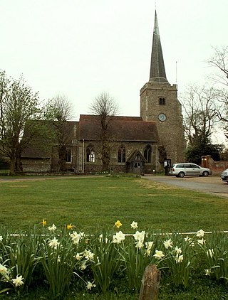
Danbury is a village in the City of Chelmsford district, in the county of Essex, England. It is located 33.5 miles (53.9 km) northeast of Charing Cross, London and has a population of approximately 6,500. It is situated on a hill 367 feet (112 m) above sea level.
The City of Chelmsford is a local government district with borough and city status in Essex, England. It is named after its main settlement, Chelmsford, which is also the county town of Essex. As well as the settlement of Chelmsford itself, the district also includes the surrounding rural area and the town of South Woodham Ferrers.
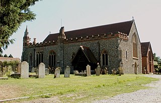
Hatfield Peverel is a village and civil parish at the centre of Essex, England. It is located 6 miles (10 km) north-east from Chelmsford, the nearest large city, to which it is connected by road and rail. The parish includes the hamlets of Nounsley and Mowden. Hatfield means a 'heathery space in the forest'; Peverel refers to William Peverel, the Norman knight granted lands in the area by William the Conqueror after the Norman invasion of 1066. Sited on high ground east of the River Ter, between Boreham and Witham on the A12, it is situated in the southern extremity of the Braintree District Council area. In 2020, the built-up area subdivision had an estimated population of 3,226. In 2011, the built-up area which includes Nounsley had a population of 3,950 and the parish had a population of 4,376.
Broomfield is a village and residential suburb in the City of Chelmsford district, immediately north of the city itself. It is the site of a major Accident & Emergency hospital. There are two public houses as well as primary and secondary schools and sports clubs.
Abridge is a village in Essex, England. It is on the River Roding, 16 miles (26 km) southwest of the county town of Chelmsford. The village is in the district of Epping Forest and in the parliamentary constituency of Brentwood and Ongar. It is part of the civil parish of Lambourne and is served by Lambourne Parish Council.
Chelmsford is a constituency in Essex represented in the House of Commons of the UK Parliament since 2017 by Vicky Ford of the Conservative Party.
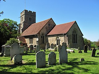
Little Baddow is a village to the east of Chelmsford, Essex.
Sandon is a village and civil parish just off junction 17 of the A12 in Essex, England, adjacent to Great Baddow and close to Danbury. The population taken at the 2011 Census includes Howe Green and totals 1,613. It was known for an ancient oak tree covering most of the village green. This rare Spanish oak was planted in 1888 to mark Queen Victoria's Golden Jubilee. It was removed for safety reasons in 2000 after collapsing due to long-standing fungal infection. Three new oak trees were planted on the village green to continue its legacy and mark Queen Elizabeth II's Golden Jubilee.
West Hanningfield is a small village and civil parish in south Essex, England. It is located approximately 5 mi (8.0 km) south-south-east of the county town of Chelmsford. The village is in the borough of Chelmsford and in the parliamentary constituency of Maldon.
Chelmsford Hockey Club is a field hockey club based in Chelmsford, Essex, England. The club's home ground is at Chelmer Park, with a capacity of 100 seats and numerous standing.
Chelmer Village is a housing, retail and industrial development in the east of Chelmsford, Essex. The development was started by Countryside Residential PLC in 1978, using a holistic approach to create a self-contained community on previously greenfield land, of the manors of Springfield Barnes and Cuton Hall. It comprises a variety of modern suburban dwellings, the Chelmer Village Retail Park and Dukes Park Industrial Estate.
Little Waltham is a village and civil parish just north of Chelmsford, in Essex, England. It is adjacent to the village of Great Waltham. The Domesday Book refers to the two villages as Waltham, consisting of several manors. The site of an Iron Age village was excavated before upgrading the main road north between the current villages.
Moulsham is a suburb of Chelmsford, Essex, England. It is located to the south of the city centre and has two distinct areas: Old Moulsham and Moulsham Lodge.
Galleywood Common is a 44.6 hectare Local Nature Reserve in Chelmsford in Essex, near the village of Galleywood. It is owned and managed by Chelmsford City Council.
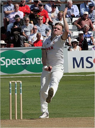
Samuel James Cook is an English cricketer. He made his first-class debut on 31 March 2016 for Loughborough MCCU against Surrey as part of the Marylebone Cricket Club University fixtures. He played for Essex against the West Indies during their tour of England in August 2017. He was part of the 2017 County Championship winning Essex squad.
Media related to Galleywood at Wikimedia Commons