Hikutavake

Last updated
Hikutavake
Hikutavake Village.jpg
Hikutavake location map.png
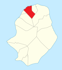
Hikutavake council within Niue
Niue Verwaltungsgliederung.png
Administrative map of Niue showing all the villages
Coordinates: 18°57′54″S169°52′53″W / 18.96500°S 169.88139°W / -18.96500; -169.88139
CountryFlag of Niue.svg Niue
Tribal Area Motu
Area
  Total
10.17 km2 (3.93 sq mi)
Population
 (2022) [1]
  Total
39
  Density3.83/km2 (9.9/sq mi)
Time zone UTC-11 (UTC-11)
Area code +683

Hikutavake is one of the fourteen villages of Niue. [2] Its population at the 2022 census was 39, down from 45 in 2017. [1]

The village was established by villagers from Tuapa. [3]

Location & geography

About 95% of the land surface is coral rock. [4]

There is a trail on the north side of Niue that leads to a clifftop to an enclosed reef with natural pools, some of them are 10 metres deep and 25 metres across. [5]

References

  1. 1 2 "Niue Census of Population and Housing 2022". Niue Statistics Office. Retrieved 20 March 2024.
  2. 1558546 (x j a h) Hikutavake on OpenStreetMap
  3. "Namukulu celebrates in style its 100th anniversary". TV Niue. Retrieved 3 December 2022.
  4. Wright, A. C. S. (1965). Soils and Agriculture of Niue Island. p. 38.
  5. Atkinson, Brett (2013-03-24). "Niue: Natural wonders". NZ Herald. ISSN   1170-0777 . Retrieved 2020-04-25.