
Romblon, officially the Province of Romblon, is an archipelagic province of the Philippines located in the Mimaropa region. Its main components include Romblon, Romblon, an archipelagic municipality of the same name that also serves as the provincial capital; Tablas, the largest island, covering nine municipalities ; Sibuyan with its three towns; as well as the smaller island municipalities of Corcuera, Banton, Concepcion, San Jose. The province lies south of Marinduque and Quezon, east of Oriental Mindoro, north of Aklan and Capiz, and west of Masbate. According to the 2020 census, it has a total population of 308,985.

Iloilo, also called Iloilo Province, officially the Province of Iloilo, is a province in the Philippines located in the Western Visayas region. Its capital and largest city is Iloilo City, the regional center of Western Visayas and politically independent from the province. Iloilo occupies the southeast portion of the Visayan island of Panay and is bordered by the province of Antique to the west, Capiz to the north, the Jintotolo Channel to the northeast, the Guimaras Strait to the east, and the Iloilo Strait and Panay Gulf to the southwest.

Pasig, officially the City of Pasig, is a highly urbanized city in the National Capital Region of the Philippines. According to the 2020 census, it has a population of 803,159 people.

Roxas, officially the City of Roxas, is a 3rd class component city and capital of the province of Capiz, Philippines. According to the 2020 census, it has a population of 179,292 people, making it the most populous city in Capiz and also the second-most populous city in Western Visayas, after Iloilo City.

Majayjay, officially as the Municipality of Majayjay, is a 4th class municipality in the province of Laguna, Philippines. As of the 2020 census, the municipality has a population of 27,893 residents.

Santa Mesa is a district in Manila, Philippines. It is surrounded by the Pasig River on the southwestern side, and by the San Juan River on its southern and eastern side. Land borders include the districts of San Miguel to the west and Sampaloc to the north; and to the northeast is Quezon City.

Loon, officially the Municipality of Loon, is a 2nd class municipality in the province of Bohol, Philippines which was established in 1753. According to the 2020 census, it has a population of 44,224 people.
Banton, officially the Municipality of Banton, is a 5th class municipality in the province of Romblon, Philippines. According to the 2020 census, it has a population of 5,737 people.

Cajidiocan, officially the Municipality of Cajidiocan, is a 3rd class municipality in the province of Romblon, Philippines. According to the 2020 census, it has a population of 23,259 people. The municipality is located on Sibuyan Island, which has been dubbed as the "Galapagos of Asia" due to its pristine natural environment and high endemism rate for flora and fauna.

Calatrava, officially the Municipality of Calatrava, is a 5th class municipality in the province of Romblon, Philippines. According to the 2020 census, it has a population of 11,342 people.

Looc, officially the Municipality of Looc, is a 4th class municipality in the province of Romblon, Philippines. According to the 2020 census, it has a population of 21,799 people.
Romblon, officially the Municipality of Romblon, is a 3rd class municipality and capital of the province of Romblon, Philippines. According to the 2020 census, it has a population of 40,554 people. The archipelagic municipality is the capital of the province of Romblon and the seat of its provincial government. It includes Romblon Island as well as the nearby islands of Lugbon, Alad and Cobrador.

San Fernando, officially the City of San Fernando, is a 1st class component city and capital of the province of Pampanga, Philippines. According to the 2020 census, it has a population of 354,666 people.

Guimba, officially the Municipality of Guimba, is a 1st class municipality in the province of Nueva Ecija, Philippines. According to the 2020 census, it has a population of 127,653 people.

Jaro is a district in Iloilo City, Philippines, located in Iloilo province, on Panay Island in the Western Visayas region. It is the largest district in terms of both geographical area and population, with 130,700 people according to the 2020 census. It is the seat of the Roman Catholic Archdiocese of Jaro, which encompasses the provinces of Iloilo, Guimaras, Antique, and Negros Occidental, as well as the center of the Candelaria devotion in the Philippines.

The Spanish fortifications of the Philippines, or fuerzas, are strongholds constructed by Filipinos and Spaniards primarily for protection against local and foreign aggressors during the Spanish colonial period, and during the subsequent American and Japanese occupations. Structures built included fortresses, watchtowers, and bastions. Many are badly damaged, either due to old age or past conflicts. Currently, there are initiatives for restorations of all forts, beginning when the Baluarte Luna of La Union and the Intramuros of Manila were restored in the 2010s. In 2013, a typhoon and earthquake hit Central Visayas and damaged numerous Spanish fortifications, leading to the largest restoration activity for fortifications in Philippine history.

Tayabas, officially the City of Tayabas, is a 6th class component city in the province of Quezon, Philippines. According to the 2020 census, it has a population of 112,658 people.

The Puente de España was a bridge that spanned the Pasig River in the Philippines, connecting the areas of Binondo and Ermita, Manila, on Calle Nueva with central Manila. The span was the oldest established in the country before it was damaged by a flood in 1914. The bridge was replaced by the Jones Bridge, constructed from 1919 to 1921, located one block downriver from Puente de España on Calle Rosario.

The Bridge of Isabel II is a historic bridge in the City of Imus in Cavite province, Philippines. The two-span stone arch bridge that was completed in 1857 was the site of the Battle of Imus, also known as the Battle of Imus River, on September 3, 1896 between the Filipino revolutionaries and the soldiers of the Spanish colonial government.

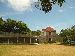
The Twin Forts of Romblon are a pair of Spanish fortifications located in the town of Romblon, Romblon in the Philippines. It was built by the Spanish in 1644 to protect the town from Muslim raids and Dutch piracy in the country during the Eighty Years' War. In 2013, the site has been declared a National Cultural Treasure under the protection of the Philippine government through the National Museum of the Philippines.


